There aren’t too many positive things one can say about this March so far. It’s been cold, it’s been snowy, and there’s still a week of it left. Unfortunately for us, this March will end just as it started – like a lion.
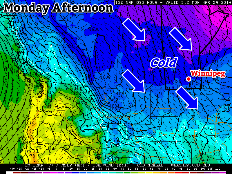
Monday will see more cold weather in southern Manitoba
Monday
Monday
-10°C / -24°C
Increasing Cloudiness. Chance of Flurries.
Today will see the continuation of well below normal weather. This morning’s lows were more akin to January than March and today’s highs will be similar to the normal lows for this time of year. That is to say we’ll see highs near the -10C mark, with this morning’s lows having been in the -20s. If the cold wasn’t bad enough, we may even see a bit of snow along a cold front today – just what you were hoping for I’m sure. This cold front will usher in some gusty north-west winds too, so any snow that does fall will be sure to blow around a bit.
Tuesday
Tuesday
-11°C / -20°C
Mainly Sunny
Tuesday will be similar Monday temperature-wise with temperatures once again well below normal. It will be a bit less windy than Monday however, with little threat for snow, which will make it slightly nicer day overall.
Wednesday
Wednesday
-6°C / -10°C
Flurries possible
Wednesday looks to be one of the warmest days this week, with highs in the mid single digits. This warmer air will be brought north by a low pressure system passing to our south. This low pressure system may even bring some snow to southern Manitoba, but it’s too early to say.
Long Range
The long range forecast continues to look abominable. Long range models continue to strongly suggest that below-normal weather will last at least through the end of March. At this point we can only hope that April will see some improvement.
After a roller-coaster ride for our temperatures over the past week, cooler weather will settle in over the Red River Valley for the weekend. Temperatures will be around 10°C below normal over the next couple days before warmer & unsettled weather begins to push in by the end of the weekend.
Friday
⇒ -12°C / -23°C
Mixed skies. Winds tapering off this afternoon.
Saturday
-14°C / -23°C
Mainly sunny.
Sunday
-7°C / -12°C
Increasing cloudiness with a chance of snow late day.
Cool, Sunny Start
A ridge of high pressure will build into the Red River Valley through the day today, tapering off the northerly winds and bringing with it cooler air from Northern Manitoba. As temperatures remain steady near -12°C, strong northerly winds at 30-40km/h will diminish to 15-20km/h by the afternoon. Skies will remain mixed through most of the day thanks to some lingering instability behind the cold front that pushed through overnight.
Temperatures will drop to around -23°C tonight as the clouds mostly clear out. Winds will be light out of the north.
Tomorrow looks very similar to today; temperatures may climb a degree or two higher under a partly cloudy sky, but we’ll still be a good 10°C below normal for this time of year. Saturday night’s temperatures will be similar to tonight’s.
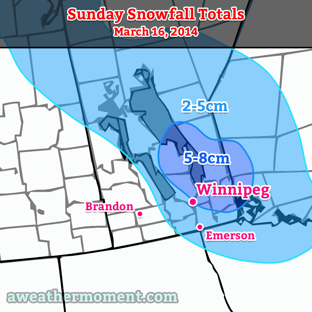
Update: Expected snowfall accumulations through Sunday night.
Sunday will bring warmer weather as milder air begins pushing eastwards thanks to another low pressure system set to track from northern Alberta through southwest Manitoba. Temperatures will climb to around -7°C with increasing cloudiness and moderate southerly winds to 30-40km/h. There will be a chance for some light snow here in Winnipeg through the evening and overnight period; amounts are still quite unclear, but it seems likely to be no more than a few centimetres. Cloudy skies will continue through Sunday night as temperatures drop to about -12°C.
Through the beginning of next week it looks like we’ll be returning towards seasonal temperatures[1] with mainly cloudy skies. It looks like there will be multiple chances for snow next week, but at the moment none of them look like significant snowfalls of any sort.
Seasonal temperatures for mid-march are around -2°C. ↩
Windier, snowier weather is on the way for Winnipeg and the Red River Valley, marking the start of a large-scale pattern shift which will bring the latest – and hopefully last – deep freeze to an end and allow more seasonal weather and temperatures to take hold.
Wednesday
-9°C / ⇑ -6°C
Windy & cloudy. Blowing snow possible. Snow in the afternoon.
Thursday
-1°C ⇓ / -18°C
Snow ending midday; breezy with temperatures falling in the afternoon.
Friday
-12°C / -20 to -25°C
Mainly sunny.
A Windy, Snowy Shift
Warmer air trying to build its way into the Red River Valley will result in increasing southerly winds today. By early this afternoon, winds will be quite strong out of the south at 40-50km/h with gusts as high as 70km/h. These strong winds – coupled with a fairly deep boundary layer – will likely produce fairly widespread blowing snow in the Red River Valley. It’s severity may be limited by relatively mild temperatures, however it’s best that anyone travelling on area highways be prepared for poor driving conditions.
Warmer air at 850mb (denoted by the yellow/red colours) will be pushing northeastwards over the next 24 hours.
By late in the afternoon, the upper-level portion of the warm front will be approaching the Manitoba border. A strengthening jet[1] overriding the 850mb baroclinic zone will provide a fair amount of isentropic lift. As the jet intensifies, as will the area of light snow pushing into Parkland Manitoba this morning. It will progress eastwards through the day and push through the Interlake and Red River Valley mid-to-late this afternoon.
It seems likely that Winnipeg will see around 2cm of snow that falls as a fairly intense, but short, burst. Areas south of the city will be more hit and miss as to whether or not snow falls. The safe thing to say is that you’re more and more likely to see snow the further north you are in the valley.
By evening our temperature will climb up to our daytime high of about -9°C. Overnight will bring the continued chance for flurries/light snow while winds diminish somewhat and temperatures continue to rise to around -7 or -6°C here in Winnipeg.
Expected storm-total snowfall by Friday morning. Snow will fall in 3 main batches.
Thursday looks to bring more snow to Winnipeg & the Red River Valley as a clipper system races along the Canada-US border. Snow will move in fairly early in the day, spreading eastwards along the Trans-Canada corridor into Winnipeg, and end early in the afternoon. In total, around 5cm is likely to fall through the morning hours – with a little less to the south of Winnipeg – while accompanied by breezy winds out of the south at around 30km/h. Winds will become gusty out of the NW at 30-50km/h in the afternoon as the system tracks off to our east.
Temperatures will climb to a positively balmy -2 or -1°C by midday before the northwesterlies begin drawing in cooler air.
Flurries & Cooler
Thursday night will bring a good chance of seeing some flurry activity as another ridge of high pressure builds in from the NW and some favourable snow-making air slides southeastwards through the region. Any accumulations would amount to only a couple cm at most, and through the night the clouds will break up and we’ll be left with partly cloudy skies by Friday morning.
Friday itself will bring cooler temperatures with a high of only around -12°C and light winds. Some cloud cover Friday night will help temperatures from dipping too much, with overnight lows dipping just below -20°C.
Spring Ahead?
Hope finally lies in the long-range models. Almost all are showing a high probability of a return to seasonal temperatures[2] within the next 2 weeks. No significant cold snaps are in the foreseeable future, and with the sun getting stronger and stronger and the days getting longer and longer, it doesn’t seem likely that we’ll see any more brutal cold snaps for the miserable winter of 2013-2014.
Don’t forget that this coming Sunday, March 9th at 2:00AM we get to do that wonderful[3] tradition of changing our clocks! We spring forward an hour, so it’ll be time to cash in that extra hour you banked way back in the fall!
A “jet” is a narrow ribbon of strong winds aloft. ↩
Which will be for daytime highs near -3°C and overnight lows near -13°C. ↩
Temperatures will slowly return to slightly below-seasonal values through the remainder of the week as unsettled weather pushes into the Red River Valley. While the main weather focus will remain further east as a significant low pressure system lifts through Central Ontario, the storm will have a broad reach spanning all the way from the Maritimes to Southern Manitoba.
This forecast precipitation panel from the GDPS shows the significant extent of this week’s develping storm.
One More Mild Day
Wednesday
-4°C / -9°C
Increasing cloud; mild. Snow overnight.
Today will bring another fairly nice day a westerly flow aloft continues spreading warm air into Southern Manitoba. Temperatures should climb up to around -4°C with relatively light southeasterly winds. Cloud coverage will increase through the day as a trough of low pressure works it’s way towards the Red River Valley, bringing with it another batch of snow and the beginning of of our transition back towards seasonal to slightly below-seasonal temperatures.
As the cloud pushes in, so too will the snow. Initially, the snow will spread into the Parkland region of the province – through Dauphin and down towards Minnedosa – before pushing eastwards into the Interlake. As the system tracks east, it will do it’s best to develop some light snow over the Red River Valley as a low-level jet ramps up and lifts over the warm front stationed in North Dakota. It’s still too early to say exactly how this is going to shape out: the location and intensity of the precipitation will have a lot to do with the exact track & timing of the system. If things line up right, we may see a band of moderate snow track across the RRV fairly early in the evening, but just as likely is that the LLJ doesn’t really get precipitation going until it’s further east into Minnesota, which could drastically reduce snowfall expectations depending on how much of that is able to wrap all the way around the low back into the Red River Valley.
Snowy Thursday
Thursday
⇒ -9°C / -15°C
Periods of light snow; 3-6cm accumulation.
Thursday looks to bring more snow Southern Manitoba as Wednesday’s system is absorbed into a much larger storm lifting northwards through Central Ontario. As a notable aside, this storm is absolutely massive, stretching from Manitoba all the way to the Maritimes and from Quebec all the way southwards to Florida.
The inherent uncertainty of both track and timing makes snowfall totals quite difficult. The highest confidence is for snow through the Parkland into the Southern Interlake and east. A combination of strong lift and a decent deformation zone look to produce a band of snow with totals from around 5-10cm. Assuming the currently forecast track of the system, we would then see around 3-6cm of snow through the northern Red River Valley – including Winnipeg – and 1-3cm or less through the southern Red River Valley.
Temperatures will be cooler on Thursday as a northwesterly wind keeps temperatures steady near -9°C. Temperatures will dip to around -15°C tomorrow night under mainly cloudy skies with a chance of a few flurries.
Cool Weekend Ahead
Friday
-13°C / -20°C
Mixed sky; chance of flurries.
Friday continues the cool trend with temperatures only recovering a degree or two – to around -13°C – while moderate northwesterly winds continue to make things unpleasant. There will be a slight chance of flurries through the day under mixed skies, but things should clear out on Friday night as we head to a low near -20°C.
The weekend will bring more cool temperatures as daytime highs slump towards -17 or 18°C under sunny skies by Sunday and overnight lows dropping below -20°C in the overnight periods.


