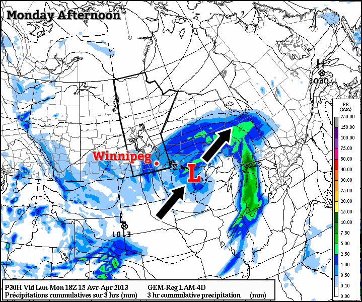
After a stormy start to the week over the entire Red River Valley, conditions will begin to settle down.
Monday
Snow ending
-1°C / -6°C
The snow will gradually taper off over Southern Manitoba today, with many places seeing close to 5cm in total. Wind speeds will remain high, with values of 30 to 40km/h gusting up to 50-60km/h from the north. Temperatures today will be around or just below zero in Southern Manitoba, but of course the wind will make it feel a bit cooler than that.
Tuesday and Wednesday
Chance of Flurries
-1°C / -7°C
Chance of Flurries
1°C / -8°C
Tuesday will be a benign day weather-wise, with high temperatures generally just below zero in Southern Manitoba. The wind will be relatively light and from the north, making for a fairly comfortable day.
Wednesday will be a bit warmer than Tuesday, but otherwise there won’t be an significant changes in conditions. The wind will again be light and from the north, with only a slight chance of flurries.
Long Range
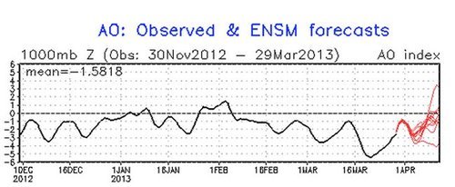
The long range forecast is beginning to show some glimmers of hope. Models are beginning to show signs of a pattern change towards normal or just above normal conditions as we move towards the end of April. Unfortunately, that means we’re likely stuck with well below normal weather at least through this week…but hopefully that will change in the not too distant future.