The “Meteorological Cliff”

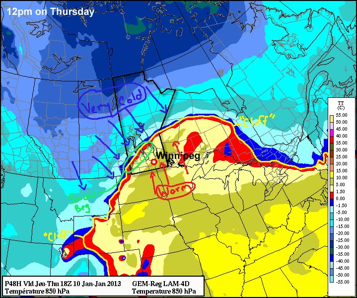
After a week of relatively pleasant, albeit somewhat sloppy, weather in Southern Manitoba we’re headed for a kind of meteorological cliff. Our weather will change dramatically this Friday, as colder and snowier weather moves in.
Location of the

Before we head off this cliff, our weather will remain very nice. High temperatures on Wednesday will be in the low minus single digits in Southern Manitoba. There may even be a few zero degree readings in south-western sections of Manitoba late in the day as warmer air surges into Manitoba. On Thursday we should reach our warmest temperatures of the week with values in the low (positive) single digits expected. Some of the traditional warm spots in Southern Manitoba may reach values slightly warmer than that. The daytime hours of Thursday will be fairly nice in most of Southern Manitoba, but conditions will begin to change in the afternoon in western areas as snow begins to move in.

Our trek off the meteorological cliff will begin on Thursday night, as snow develops over Southern Manitoba. The snow is expected to begin on Thursday afternoon (or early evening) in Western Manitoba, eventually moving spreading through the remainder of Southern Manitoba by late Thursday evening or very early Friday morning. Total accumulations from this initial batch of snow will generally be in the 2 to 5cm range in Southern Manitoba. By Friday morning temperatures will have fallen into the mid minus teens over much of Southern Manitoba. Snow is expected to taper off from west to east in Southern Manitoba on Friday morning, with south-eastern sections seeing snow linger the longest. The second wave of snow moves in on Friday night. This wave will be generated as a strong Colorado Low system moves up from the south. At this point it appears that this secondary wave of snow will bring another 2 to 4cm to Winnipeg and another 4 to 8cm to south-eastern Manitoba. It is entirely possible that the amounts from this secondary area of snow could be higher or lower than listed above. Depending on where the system ends up tracking Winnipeg could end up with more snow, or perhaps none at all. However, I do believe south-eastern Manitoba will receive some snow during this time period, though again it could be more or less than I have listed above.
Location of the

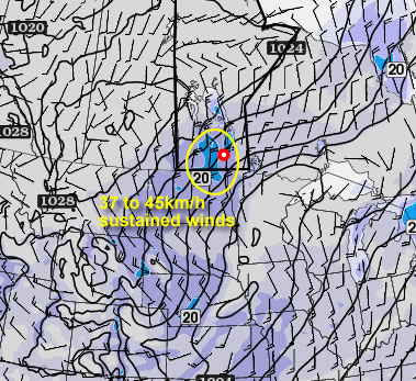
A secondary concern will develop on Friday as strong north winds develop in response to the intensification of the Colorado Low. At this point it appears that northerly winds of 40km/h gusting to 60km/h, or maybe even 50km/h gusting to 70km/h on a more localized basis, will materialize on Friday. This could create significant travel difficulties as blizzard conditions, or near blizzard conditions may develop as these very strong winds interact with the fresh snow. It is too early to say exactly how bad things may get, but this is certainly something that will need to be monitored closely over the next few days. Please continue to check back with A Weather Moment for further updates on this developing weather story.

After this Colorado Low passes by, conditions will turn calm, but cold. At this point most models keep us in very cold air for basically all of the next ten days. Arctic air doesn’t make a habit of moving around very quickly, so it is likely that we’ll remain in this arctic air mass for an extended period of time. There may be some warmer days here and there, but those details are not yet known with any certainty.

Enjoy these last couple warm days, as winter is quietly waiting to push us off the meteorological cliff.
A Break From Winter

This week will feature a much needed break from winter, as temperatures soar to well above seasonal values.

Surface Temperatures

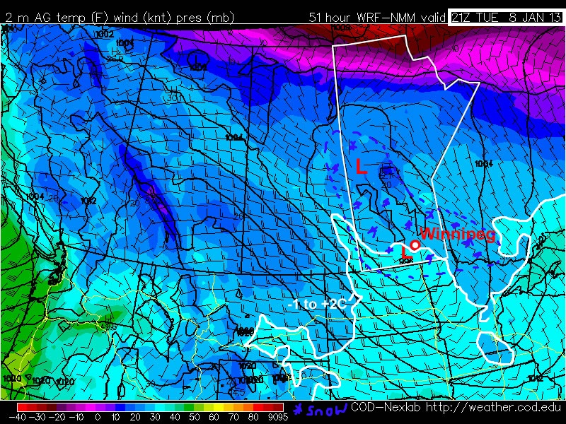
Temperatures on Monday will reach the mid minus single digits in Southern Manitoba. There will be a fairly stiff west wind in place throughout the day though, which will make conditions considerably less comfortable than they would otherwise be. On Tuesday we’ll have our first shot at the 0C mark this week, as a low pressure system brings in a warm surge of air from the west. Unfortunately there may be some snow on Tuesday associated with the low pressure system. Amounts will not be particularly high, probably no more than a few centimetres in most areas. Despite the small amounts there could be travel difficulties as the snow is likely to be wet in nature and could present icing issues.

On Wednesday temperatures will remain warm, with highs just slightly below the freezing mark in most areas. We’ll have our best shot at getting above zero on Thursday as a big push of warm air moves into Manitoba from the south-west.

At this point it appears that this warm spell will end on Friday, with a low pressure system passing to our south prompting another arctic air mass to descend into Southern Manitoba. This system may bring a decent snowfall to portions of Southern Manitoba on Friday as well, though it is too early to discuss the details of it. In the longer range most indications suggest that we are in a for a very cold period through the middle of January, with a significant arctic air mass settling over the Prairies. With that in mind, there is all the more reason to enjoy this week’s pleasant “break” from winter.

Clouds To Start Breaking Up

The overcast weather will begin to break this weekend as a system tracking through the central Prairies brings drier air eastwards across the Prairies. Temperatures will cool off with the clearing skies, but the sun will be a welcome sight that may make many not care.

Snow in Assiniboine Park

A snowy, overcast scene at Assiniboine Park, courtesy “Mentally Guitarded.”

Clouds will stick around for today with continued periods of light snow as temperatures continue to remain in the optimal snow-generating range. Winds will be light out of the south as we reside on the back-side of a ridge which passed through overnight and temperatures will climb to around -11°C. As a low pressure system tracks across the Prairies tomorrow, higher-level cloud will begin to stream over Southern Manitoba. This mid-cloud will help produce scattered snow showers in areas that have been socked in with low cloud for a while, but also begin to dissipate that persistent low cloud as well.

On Saturday we’ll likely see a mix of sun and cloud as more mid-level cloud streams over the southern portion of the province. There should be some sunny breaks as well and temperatures will climb once again to around -12°C. Clouds will break up a little overnight as cooler air pushes in from the northwest behind this system and we’ll head to an overnight low closer to -20°C. By Sunday, we should see a little more sun than on Saturday with temperatures climbing only to around -16 or -15°C. No significant snow accumulations are expected through the weekend.

Next week, including Christmas, is looking fairly sunny and cool, with overnight lows near -25°C and daytime highs near -18°C. We’ll be taking a slight vacation over Christmas here at AWM, so have a great holiday and a happy new year!

Snow Today, Cooler For Week’s End

Light snow will very slowly taper off through the day today, leaving us with slowly clearing skies and cooler weather.

NAM Sounding valid 4PM Wed Dec 19

A sounding from the NAM for Winnipeg valid at 4PM today. The areas of the line that are coloured yellow denote effective snow making regions in the atmosphere (a combination of temperature & humidity).

Light snow that pushed into the Red River Valley overnight will taper off this evening; despite the fact that the system will be pushing out of the province mid-day, the temperature structure of the lowest 2-3km of the atmosphere will remain highly favourable for the generation of snow, so we’ll likely see additional snowfall through the day today similar to Monday. In total we’ll likely see 4-8cm of new snow through the Red River Valley. Clouds look to begin to break up overnight leading to a cooler night than we’ve had lately with temperatures dropping to around -15°C.

Thursday will bring mainly sunny skies with very little temperature recovery; daytime highs through the RRV will be only -14 or -13°C. The clear skies look to persist through week’s end as cooler air continues to push into the region: overnight lows on Thursday night will drop another couple degrees to about -18°C while temperatures look to climb to only around -15°C again on Friday.

The weekend looks clear but cool, with overnight lows near -25°C and daytime highs near -20°C.