First Summer Blast Will Bring Muggy Weather & Severe Thunderstorm Threat

The first real notable surge of summer air is on the way for Winnipeg as a broad southerly flow develops ahead of a slow-moving low pressure system moving across Saskatchewan. This organized flow of southerly air will tap into Gulf moisture[1], bringing the first notably humid spell of 2016 to Winnipeg. Alongside the heat and humidity that will move in, there will be a threat of thunderstorm development across Southern Manitoba, of which severe storms are certainly possible.

Today marks the start of the summer surge moving into Southern Manitoba as light southerly winds develop over the Red River Valley and warmer air aloft begins to move into the region. Skies will partly cloudy to mixed through much of the day as temperatures climb to a high near 24°C. The humidity will still be fairly comfortable today with dewpoint values in the low teens.

Heading into the late afternoon and evening, cloud cover will thicken up over Winnipeg & the Red River Valley as some precipitation develops associated with instability ahead of the approaching warm front. Winnipeg will see a decent chance of seeing some light rain overnight, but amounts will likely remain under a few mm. Temperatures will dip to a low near 14°C tonight.

RDPS Forecast Temperatures valid Wednesday Afternoon
The RDPS shows very warm temperatures in Southern Saskatchewan this afternoon, indicative of the hot air mass set to move into Manitoba tomorrow.

Thursday will be the most significant day over Southern Manitoba as the full brunt of a hot and humid air mass settles over the province. Temperatures will soar to a high near 28°C while the humidity becomes particularly swampy, with dewpoint temperatures likely to climb to the 19-21°C range. This will feel quite sticky, especially as the first humid spell of the year, as humidex values climb toward the mid-30’s for the afternoon.

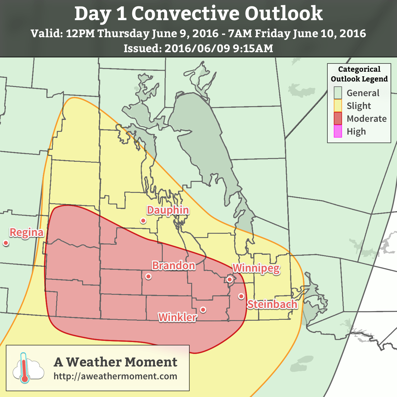
With the heat and humidity in place, attention turns towards thunderstorm potential. This setup has been interesting to watch develop over the last week as models have struggled to resolve exactly how much moisture would arrive in the province and how warm temperatures aloft would get. That said, there’s a severe thunderstorm risk today that will start over southeastern Saskatchewan with afternoon thunderstorm development possible. The threat will then shift eastwards through the evening and overnight with thunderstorms transitioning from surface-based to elevated as the low-level jet strengthens, helping the scattered afternoon activity grow upscale into a larger area of rain and thunderstorms.

AWM Day 1 Convective Outlook valid June 9-10, 2016

Taking a more technical look at it, as usual we return to the basic MIST principles:

  • Moisture: With surface dewpoints climbing towards or even over 20°C, ample moisture will be in place for thunderstorm development. The low-level jet that develops Thursday evening will also be helping propagate elevated moisture levels northwards.
  • Instability: Significant instability is in place with MLCAPE values in excess of 2000 J/kg developing over much of th region. MUCAPE values continue above 2000 J/kg through the overnight period. CAPE also appears to be fairly "fat", bolstered by potent mid-level lapse rates over 8°C/km.
  • Shear: Ample speed and directional shear will be in place with 0-6km bulk shear values of 35-50kt and strongly veering profiles. Low-level wind profiles in eastern Saskatchewan & western Manitoba will favour discrete supercell thunderstorm development with storm motion to the east-southeast.
  • Trigger: Strong solar insolation coupled with an incipient thermal wave and associated boundaries should provide multiple foci for thunderstorm initiation.

In general, it’s expected that discrete supercell thunderstorms with primary threats of damaging hail, wind gusts in excess of 100 km/h and a non-zero tornado threat. These storms will likely be scattered and progress to the east-southeast. As the evening wears on and the low-level get strengthens, the scattered activity has a high probability of growing upscale and organizing into an MCS[2]. If an MCS develops and moves eastwards, then the primary threats will be heavy rain and damaging hail. There is growing confidence that the MCS will develop into a bow echo, which is a fast-moving storm that produces severe wind gusts. Should this occur, than much of southwestern Manitoba and the Red River Valley will see a very significant threat of damaging hail and severe winds.

Temperatures will remain quite warm on Thursday night with low temperatures throughout the Red River Valley near 20°C.

Friday will continue to be warm with mainly sunny skies once any overnight convection clears out of the region. Temperatures will rocket to the upper 20’s by midday and while the highest humidity will push off to the east, it will still remain a bit muggy with dewpoint values stabilizing near 15-17°C. Winds will shift to be out of the northwest at around 20km/h. Expect a low on Friday night near 15°C.

Winnipeg’s seasonal daytime high is currently 23°C while the seasonal overnight low is 10°C.


  1. In the summer, deep southerly flows over the Eastern Prairies tap into humidity from the Gulf of Mexico and pull it northwards across the Great Plains and into the Southern Prairies.  ↩
  2. Mesoscale Convective System: A cloud system that occurs in connection with an ensemble of thunderstorms and produces a contiguous precipitation area on the order of 100 km or more in horizontal scale in at least one direction.  ↩

A Couple More Cool Days Before We Heat Up

We’ll have a couple days of cool weather before an upper ridge builds in, bringing hot & humid weather to southern Manitoba in the second half of the week. The arrival of the heat and humidity is also expected to bring our first significant risk of severe thunderstorms this year.

A cool northerly flow will be in place over southern Manitoba on Monday

This Week

Today will remain on the cool side as a surface high to our north-west pumps cool air into southern Manitoba. Some cloud cover is expected in southern Manitoba during the morning as an upper disturbance moves through, but skies should clear by the afternoon. Daytime highs will be in the upper teens with gusty north winds at 40 km/h gusting to 60 km/h.

Tuesday will remain cool as we remain under the influence of that surface high. Temperatures will once again be in the upper teens, although some areas in western Manitoba may reach the low twenties. Skies are expected to be mainly sunny and winds will be breezy from the north.

Warmer weather will begin to move into southern Manitoba on Wednesday as the surface high moves off to the east. A southerly flow will be in place over southern Manitoba, helping to bring warmer air into the region and push daytime highs into the mid twenties over the Red River Valley and the upper twenties over western Manitoba. There will likely be a risk of severe thunderstorms in eastern Saskatchewan on Wednesday and that may spill over into western Manitoba. Depending on how conditions develop, the thunderstorm risk may extend across all of southern Manitoba on Wednesday night as storms from Wednesday evening move east with time. A westerly steering flow and a strong southerly low-level jet would tend to favour easterly or south-easterly storm motions, which would help steer storms toward the Red River Valley during the overnight period. More details on Wednesday’s potential thunderstorm risk will be available as the week progresses.

Long Range

The long range forecast suggests a hot, but unsettled pattern, will be in place for southern Manitoba from late this week into the weekend. An upper ridge will be centred over southern Manitoba during this time period, but we are expected to remain at the top of this ridge, putting us along the storm track. The influx of warm, humid air due to the southerly flow in this ridge combined with the moderate to strong flow with the jet stream aloft should favour numerous thunderstorm chances during the Wednesday-Monday period. The nature of the thunderstorm threat remains quite unclear, but at least one or two severe events seems probable at this time. An upper trough is expected to approach either late this weekend or next week, which will push out this hot/humid air mass.

Unsettled Friday Leads to Pleasant Weekend

A showery and unsettled end to the week will mark the final day with precipitation before a stretch of drier weather builds into the Red River Valley for the weekend and into the first half of next week.

Today will be a rather unsettled day for Southern Manitoba as an upper-level low tracks into southwestern corner of the province. This morning starts out with the remnants of overnight convection tapering off over the Red River Valley, then attention will shift westwards as further thunderstorm development focuses along a trough extending from northeastern North Dakota back towards southeastern Saskatchewan.

AWM Day 1 Convective Outlook for June 3, 2016

In general, scattered non-severe thunderstorms are possible throughout western and south-central Manitoba today. MLCAPE values of 400-800 J/kg will be enough to help some thunderstorm development occur, but weak shear and unfavourable moisture profiles will limit their strength. The main area of note runs from Yorkton, SK into southwestern Manitoba then southward into North Dakota, indicated by the hatched area on the map. In this area, a surface trough combined with better daytime heating and the approach of the upper-level low will introduce the possibility of some non-supercell funnel clouds as thunderstorms develop midday into the afternoon. These can often be eye-catching, but generally pose little threat and are short-lived. That said, if a non-supercell funnel cloud touches the ground, it is considered a tornado, although they too are also typically weak and short-lived.

In Winnipeg, the best chance for shower or thundershower activity will be this morning as any remnants move into the Red River Valley. The remainder of the day will be cloudy with a slight chance of some showers or thundershowers re-developing in the afternoon. Expect a high near 20°C with winds out of the southeast at 15-25km/h. Skies will clear this evening as temperatures drop to around 12°C.

Dry & Mild Weekend

The weekend, on the other hand, will be comparatively pleasant in Winnipeg & the Red River Valley. Skies will be partly cloudy to mixed on Saturday and mainly sunny on Sunday. Daytime highs both days will be in the low 20’s with overnight lows in the low teens. Winds will be fairly light out of the northwest on Saturday at 10-20km/h, but Sunday will be winder with northwest winds to 30-40km/h.

Winnipeg’s seasonal daytime high is currently 22°C while the seasonal overnight low is 9°C.

Forecast Update – Unsettled Weather Continues for Saturday

A bit of an update is required for today’s forecast as this weather system has evolved in a slightly different way than was expected when originally written on Thursday night.

The overall pattern has progressed to the east more slowly than originally thought, largely in part due to the stalling of an upper low in northern Minnesota. As a result, cloudier skies have remained in the Red River Valley, and some precipitation that was expected to be to our east today has not yet past.

Radarscope Reflectivity - 8:20AM June 4, 2016
A weak area of showers descends towards Winnipeg from the Interlake.

For Winnipeg, well see a few light showers through the morning hours as a weak area of lift moves through from the Interlake. The extent of the showers will be fairly limited and largely confined to the northern half of the Red River Valley. These will taper off by mid-day, but be replaced by a chance for the development of afternoon showers with a slight risk of a thundershower as a trough moves through the region. This trough was fairly active yesterday, but will be far more benign today as less upper-level support is in place. The best chance for showers this afternoon will be over southeastern Manitoba through the Whiteshell and down towards Sprague.

Once we start clearing out for the afternoon, we should still be able to reach our high near 21°C-22°C with light winds.

Little Time to Dry Out

Showers will taper off today across Southern Manitoba and be replaced with sunshine for Thursday. The reprieve from the wet weather will be short-lived, however, as another low pressure system tracking across the Prairies on Friday will spread more showers back into the region.

Today will be a cool, damp day once again throughout Winnipeg & the Red River Valley as the main upper-level low drags a final swath of rain and showers through the region as it exits into Ontario. Further amounts should be relatively light with anywhere from a trace to 10mm possible over the Red River Valley1 with the bulk of the organized rain falling before noon. A few scattered showers will remain through the region this afternoon as northerly winds to 30-40km/h move into the region. The wind and shower activity will taper off this evening. Temperatures will reach a high of just 12°C—a full 10°C below normal for this time of year—and with clearing skies tonight lows will dip to around the 7°C mark.

RDPS 12hr Precipitation Totals valid 00Z Thursday June 2, 2016
The RDPS is forecasting a further 2-15mm over the Red River Valley today.

Thursday will be a pleasant day with just a few afternoon clouds, light winds and a high near 20°C. Temperatures will dip to 12°C on Thursday night as cloud cover moves in from the west as the next low pressure system moves into the region.

Friday will bring shower activity back to the Red River Valley as an occluding frontal wave associated with a low pressure system forecast to track through the Interlake moves into the region. Early morning showers appear likely at this point2, but they will push off to the east through the morning, leaving behind some mixed skies. Temperatures will climb to around the 20°C mark, which will likely be all we need to re-develop convection along a trough3 that will be located somewhere between Brandon and Winnipeg.

GDPS 12hr. Precipitation valid 00Z Saturday June 4, 2016
The GDPS has scattered convection along a trough on Friday, which runs from the SW RRV northwestwards through Parkland Manitoba.

The thunderstorm potential actually looks like strong to marginally severe thunderstorms may be possible. Going over the MIST ingredients:

  • Moisture: Dewpoint values are expected to climb towards the 15°C mark, which should provide suitable amounts of moisture for thunderstorm development.
  • Instability: With temperature and dewpoint values of 20°C/15°C, MLCAPE values are expected to climb to around 1000 J/kg, on the lower end of things.
  • Shear: Weak 0-6km bulk shear will be in place at just 15-25kt.
  • Trigger: A trough should provide enough focus to trigger convective development.

All these combine to make moderate-to-strong thunderstorms possible. Limited instability coupled with weak shear make severe thunderstorms unlikely; the primary threat at this point from storms would be heavy rain, but it looks like the thunderstorms should be moving at 20-30km/h which should limit the amount of water these storms will be able to dump over any one location. Skies will begin to break up out on Friday night as temperatures head to a low near 12°C.

Long Range

The weekend finally looks nice!

Both Saturday and Sunday appear to be bringing partly cloudy to sunny skies with highs in the low 20's. Overnight lows will be near 12°C. Winds will remain out of the north to northwest at 15-25km/h. Really not much to say; it appears that the Red River Valley will finally get a chance to dry out!

Winnipeg’s seasonal daytime high is currently 22°C while the seasonal overnight low is 9°C.

  1. Lightest amounts will be over the western Red River Valley, while higher amounts will be over the eastern and southeastern Red River Valley.
  2. Although they may be dependent on the magnitude and nature of the convection that manages to develop along this feature in Saskatchewan on Thursday afternoon and how it sustains over southwestern Manitoba on Thursday night. Precipitation dependant on the development and transition of thunderstorms into larger rain features is notoriously difficult to forecast.
  3. A trough is a weather feature that marks the line along which winds are converging. For an example, a line where winds are blowing to the east on the western side and to the west on the eastern side. Troughs are focus points for thunderstorms because where the winds at the surface come together, the only way to go is up!