Early Week Risk of Storms

This week will start out with a risk of thunderstorms. Monday will likely feature severe storms from eastern Saskatchewan into western Manitoba, while Tuesday may see storms through the Red River Valley and south-eastern Manitoba.

A low pressure system over North Dakota will be the focus for severe storms today. The red line is the warm front, brown line is a dryline, and blue lines is a cold front.

This Week

Monday

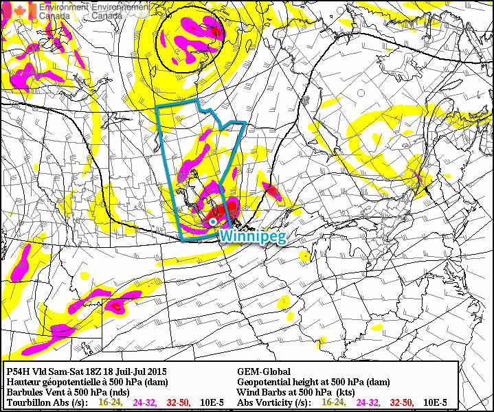
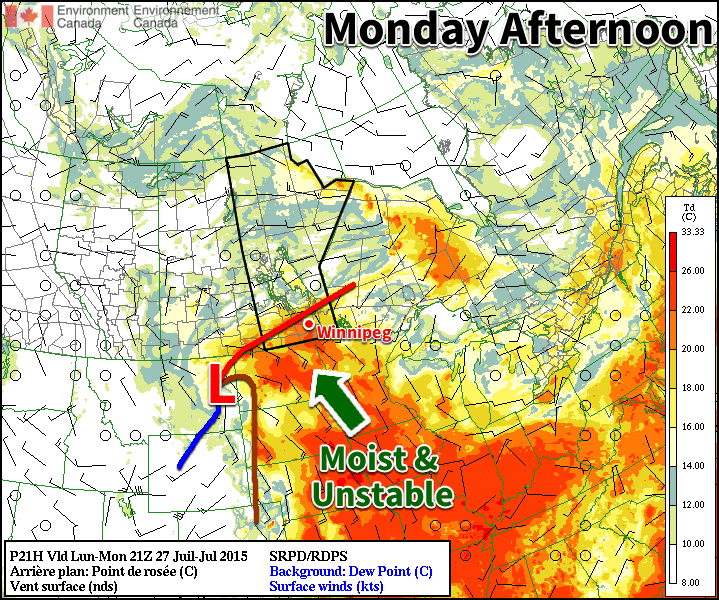
Today’s weather will have two key features; the risk of thunderstorms, and hot, humid conditions (these two attributes are linked incidentally). Temperatures are expected to climb into the low thirties across southern Manitoba, with the humidity pushing humidex values to around 40 in many areas, making it essentially a repeat of Sunday. However, there will also be a risk of severe storms in western Manitoba. This risk of storms will result from the combination of a hot, humid air mass over the region and a strong jet stream aloft. Any storms that do develop, particularly during the evening hours from south-eastern Saskatchewan into south-western Manitoba, could be very severe. There will be a risk of large to very large hail, damaging winds, heavy rain, and tornadoes. There is a risk that storms may fail to develop due to warm air aloft, although it seems more likely than not that there will be storms. A technical discussion on the thunderstorm risk over the next two days is available at the end of this post.

Tuesday

Tuesday will see a strong cold front push through southern Manitoba. The atmosphere ahead of this front will be unstable, potentially allowing some storms to develop ahead of it. The front is expected to pass through southern Manitoba relatively early in the day, limiting the potential for severe storms. However, if storms do develop early in the morning, we may see some strong cells push through the Red River Valley and south-eastern Manitoba before they exit into Ontario. Once the cold front passes, the humidity will drop noticeably, but temperatures will remain in the mid twenties with a gusty south-west wind.

Wednesday

Wednesday should be a fairly benign day in southern Manitoba, with breezy west winds and temperatures in the mid twenties. Skies should be mainly sunny and no significant precipitation is expected. For many thunderstorm-weary residents of Manitoba, this will come as a welcome break.

Technical Discussion

Monday

Dynamics:
An unseasonably strong upper trough will move across the southern prairies early this week. A lee cyclone will push onto the great plains early Monday, with the surface low centre being located near Dickinson, ND by Monday evening. A warm front will arc northwestward from the surface low to near Melita, MB and up toward the southern basin of Lake Winnipeg. A dryline will extend southward from the low, and a cold front will extend off to the south-west. This low will be associated with a strong upper trough, with 500 mb jet streaks of 50 kts over Wyoming and southern Saskatchewan on Monday evening. The exit region of a strong 80 kts 250 mb jet streak will be edging into the Dakota by Monday evening. In the low-levels a 30-40 kts LLJ will extend from the central plains into southern MB/SK. The result of the synoptic regime will be effective shear of 40-60 kts in the vicinity of the warm front.

Thermodynamics:
A moisture-rich air mass will be in place within the warm sector of the surface cyclone. 100 mb mean mixing ratios of 17-19 g/kg seem likely in the vicinity of the warm front, generating MLCAPE in the 3000-4000 J/kg range. A strongly veering low to mid-level wind profile will result in strong WAA in the 850-700 mb layer, generating sizeable capping inversions in most of the warm sector.

Overall Discussion:
Today will feature a moderate risk of severe thunderstorms from SE SK into SW MB. A moderately to extremely unstable air mass will be coincident with strong effective shear and strong ERSH. Main concern is the capping inversion that will result from low/mid-level WAA. It appears probably that some surface-based supercells may occur along the warm front, through the triple point region, and down the cold front today. Strong moisture convergence near the warm front, aided by the expected ejection of numerous weak vort maxes from the upper trough should trigger storms. Any storms that develop will produce large to very large hail, damaging winds, and potentially a few tornadoes. Tornado chances will likely be maximized through mid-evening at the LLJ increases and LCL heights decrease. The location of the warm front remains a question, as isentropic ascent of the LLJ on the warm front may generate extensive elevated convection in parts of southern SK. The primary surface-based risk may be pushed into ND under that scenario. Later in the period cold-pool mergers may allow for upscale growth into one or more forward-propagating MCSs. The cloud layer shear and LLJ orientations suggest a westward-moving system in ND that may impact parts of southern Manitoba, with the potential for severe weather primarily being along and south of the intl border. A second MCS may track NE-ward into the Interlake region. This second MCS would be non-severe owing to an unfavourable LLJ orientation – preventing strong dynamic lift for slabular convection – and decreasing deep layer shear.

Tuesday
A strong cold front will move through southern Manitoba on Tuesday, potentially triggering thunderstorms. Strong effective shear will be present in association with the frontal passage, however thermodynamic profiles suggest some capping to surface-based/near surface-based convection. Thus, it remains unclear if any storms will be possible before the front exits the province. Should storms develop, they may be severe with large hail and damaging winds being the main threats.

Humid Weather Brings Thunderstorm Threat to Southern Manitoba

The remainder of this week will be marked by a notable increase in the humidity as a deep southerly allows the moisture to build into Southern Manitoba. Alongside the sweltering conditions, a low pressure system pushing across the Prairies over the coming days will bring a threat for strong to severe thunderstorms across Southern Saskatchewan & Southern Manitoba.

Today will be a hot day with the humidity gradually building in through the day. Winds will strengthen through the day out of the south to southeast to around 30km/h or so as temperatures climb into the upper 20’s. Skies will remain mainly sunny with just a few clouds expected. While the humidity will be comfortable to start the day with dew point values around 14°C or so, the weather will get considerably stickier as the day progresses with dew point values climbing into the upper teens or perhaps even hitting the 20°C mark in the evening. This will make for very humid conditions with humidex values in the mid–30’s.

RDPS Surface Dewpoint valid 21Z July 23, 2015
The RDPS shows dew point values climbing over the 20°C mark Thursday afternoon resulting in very humid conditions.

Thursday will be the significant weather day for the second half of the week as a trough of low pressure passes across Southern Manitoba. Temperatures will soar towards the 30°C mark with significant humidity as dew point values once again push towards the 20°C mark, making the afternoon feel more like the upper 30’s. Winds will be lighter on Thursday than they will be on Wednesday, but there may be some brief breeziness late in the morning or early in the afternoon.

AWM Day 2 Convective Outlook for Thursday July 23, 2015
A slight risk of severe thunderstorms exists today across much of southwestern Manitoba extending into the Interlake and Red River Valley.

The heat and humidity will combine to pose a risk for some potent thunderstorm activity tomorrow afternoon. A trough of low pressure moving across the Red River Valley will serve as a trigger for convective activity sometime mid-to-late afternoon.[1] Winnipeg & the Red River Valley will see the risk for strong to severe thunderstorms – given a few conditions work out, more on that later – with large hail, strong winds and torrential downpours the primary threats. If an organized supercell manages to develop, the tornado threat with it (or them) will be slightly elevated. Looking through the guiding MIST principle for assessing convection:

  • Moisture: Abundant. Moisture transport coupled with vigorous evapotranspiration will combine to produce elevated surface dew point values near or exceeding 20°C by the end of the day.
  • Instability: Moderate instability with marked height falls ahead of an approaching shortwave coupled with the elevated moisture available through the boundary layer will produce MLCAPE values in the 2500 – 3000 J/kg range. The instability will carry into the evening hours with MUCAPE values remaining in the 2000+ J/kg range.
  • Shear: Pretty good. Bulk shear values of 20–30kt will increase towards 30–40kt in the evening hours. Additionally, low-level profiles show moderate veering. The wind profiles support supercell or multi-cell storm development with upscale growth likely in the evening hours.
  • Trigger: As mentioned, the trough pushing through the region associated with a low pressure system moving through the Dakotas will provide sufficient convergence to trigger thunderstorm activity.

The end result of all this is that thunderstorms are likely through Southwest Manitoba in the afternoon, with the threat pushing eastwards into the Red River Valley late afternoon into the evening. Storms will likely originate as supercells or multi-cell storms. Primary threats will be large hail and torrential rain, shifting towards hail/rain/wind as the storms organize & expand in coverage heading eastwards. Any supercell storms that manage to develop will likely pose a slight tornado risk.

Showers or thunderstorms are very likely Thursday evening/night as the system moves through. Stay alert of any watches or warnings issued by Environment Canada through the day into the evening on Thursday.

Friday will be a fairly quiet day. Things will stabilize behind the departing trough of low pressure, bringing clearing skies and a high in the upper 20’s with decreasing humidity. Expect a low in the upper teens on Friday night.

Summer Heat Returns for Weekend

The reprieve from the heat and humidity will be short-lived, however, as temperatures will climb back up to the 30°C mark with humid conditions returning as dew point values of 20°C or greater building back into the region. No precipitation is expected through the weekend.


  1. Although a wildcard remains of how long nocturnal convection from Wednesday night will persist into the daytime hours on Thursday.  ↩

Thunderstorm Chances Continue into Weekend

The generally unsettled weather that has been in place over Southern Manitoba over the past week will continue for at least a couple more days as a large upper-level low pushes across the Prairies. For those tired of sweating the heat, though, a reprieve is on the way as drier air finally works its way into the Red River Valley.

Today will be a fairly pleasant day with a fairly sunny start and temperatures poised to climb up to around 26 or 27°C. As the temperatures warm up this afternoon, shower and thunderstorm activity will likely develop as a cold front pushes eastwards into the Red River Valley. Most areas through the valley will have a chance at seeing some shower or thunderstorm activity, however the chance will increase the closer you find yourself to the U.S. border. Any convection that does develop will push out the eastern RRV early in the evening, ushering in some cooler, notably drier air into the region behind the cold front. Friday night will mark the end of a very humid streak that has seen dew points in the upper teens or low 20’s for over a week. Expect a refreshingly cool overnight low of around 12°C.

GDPS Forecasted 500mb Heights & Vorticity for Mid-day Saturday
Saturday will bring a risk of thunderstorms and funnel clouds to the Red River Valley as a vorticity-rich upper-level low moves over the region.

Saturday will bring yet another chance for showers and thunderstorms as the main upper-level low moves over Southern Manitoba. Temperatures will climb to around 22°C, which may be enough to pose a marginal risk for some severe thunderstorms in the afternoon; the biggest impact to be aware of, however, is the potential for cold core funnel clouds. These funnel clouds are developed through entirely different mechanisms than their stronger, supercell thunderstorm counterparts, and are substantially weaker and rarely result in a touchdown. If a cold core funnel cloud does reach the ground, it’s considered a landspout tornado. These tornadoes are short lived and usually very weak. While they do not pose the level of threat that a supercell thunderstorm tornado would pose, strong winds of any type can be dangerous. The shower and thunderstorm activity will push out of the region in the evening and we’ll see clearing skies as the low heads back down to around 12°C.

Sunday’s forecast will be short. Beautiful weather is on tap with highs in the mid–20’s, comfortable humidity, light westerly winds and mostly sunny skies. No complaints! Expect a low on Sunday night in the mid-teens. Finally some good weather news for a change!

Unsettled Weather Continues To Week’s End

The unsettled weather that’s been in place for the last few days will continue through the end of the week as the general instability remains in place as more weather systems push through the region.

Today will be a fairly pleasant day that’s quite similar to yesterday other than a couple degrees warmer. Temperatures should climb to around 28°C this afternoon with more clouds popping up and developing into an afternoon/evening chance of some scattered thunderstorms. Thunderstorm activity should be fairly limited as the main story will be the low pressure system that will move into Southern Manitoba overnight and will set the stage for Thursday’s weather. Expect temperatures to dip to just 19°C as increasing cloud and the humidity continue to keep temperatures warm.

Thursday Brings Heavy Rain Potential

Tomorrow may actually end up being quite a wet day as multiple models are showing a low pressure system moving through tapping into the ample moisture in the region to produce a fairly large, and intense, area of rain.

NAM Precipitable Water Forecast for 15Z Thursday July 16, 2015

The NAM (shown above) is forecasting precipitable water values as high as 1.8 to 1.9” (in the 45–50mm range) which is very high for our region. Precipitable water correlates strongly to potential rainfall amounts of storm systems[1], so it’s not unrealistic to say that rainfall totals of 1.5” to 2” (~ 35 – 50mm) are not out of the question albeit on the high end. If heavy convection were to set up, then even higher amounts would be possible. We’ll keep an eye on things and see how the storm progresses this evening; if the outlook changes much, we’ll provide an update at the bottom of this post.

So, the general forecast for Thursday would see the rain moving in overnight on Wednesday night and see the rain persisting at least until mid-day, but possibly into the late afternoon or early evening. Rainfall totals may end up being variable, but in general will likely be 20–40mm with the potential of seeing double that if system becomes vigorous enough. The high temperature will be in the 21 to 23°C range with an overnight low around 16°C. Winds will be fairly light much of the day.

Friday

The thunderstorm risk returns Friday, although it will be a fairly mild risk with just some isolated to scattered non-severe storms possible. The daytime high will sit near 26 or 27°C with light winds out of the southwest. The humidity continues to remain fairly high with dew points in the high teens. Skies will clear out Friday night as we head to a low near 15°C.


  1. Thunderstorm rainfall totals can greatly exceed PWAT values due to the convergence of the inflow wind that can “accumulate” PWAT from areas around the storm.  ↩