Mixed Weekend Ahead

The warm, mostly sunny weather of the past few days will give way to more unsettled conditions as a low pressure system anchors itself in Central Saskatchewan allowing a trough to sit over Southern Manitoba as a second low works it’s way across the Northern Plains of the United States. Showers will try to get going across Southern Manitoba but their coverage will be heavily limited by a lack of upper-level support over the region.

Today


24°C / 12°C
Sunny with cloudy periods. Chance of showers or a thunderstorm in the afternoon.

We’ll start off with some lingering clouds this morning with a chance of a few scattered showers as the remnants of a weak cold front wash out over the Red River Valley. We’ll then see a bit of short-lived clearing before skies cloud up this afternoon once we get warm enough to get some convection going. There will be enough instability around to produce a few afternoon showers or perhaps even a weak thunderstorm or two. Lifted Index values will be sitting at only –1 or –2°C which represents only marginal instability and CAPEs agree with values only around 500–750J/kg.

With little forcing in the area, the most favourable area for showers or thunderstorms will be near subtle convergence features; in our case, that will mean near either the western escarpment of the Red River Valley or any lake breeze convergence lines that form to the north and northwest of the city. At the moment it’s looking like the most potential for a thunderstorm sits west of Winnipeg in the Red River Valley, but there’s certainly a chance we may see an afternoon thunderstorm here in the city. Aside from the potential showers & thunderstorms, it will actually be a fairly pleasant day. Winds will be fairly light through the day and we’ll be climb to a high near 24°C. Skies will clear tonight as we head to a low of around 12°C.

Saturday & Sunday

Saturday

23°C / 12°C
Increasing cloudiness then a few showers or rain.
Sunday

24°C / 12·C
Mix of sun and clouds. Showers likely southwest of Winnipeg.

After a sunny start, skies will cloud over on Saturday as a trough connecting a low pressure system in central Saskatchewan and a low pressure system pushing into the Dakotas. There will some showers ahead of the trough line that will push through the Red River Valley in the afternoon. Rainfall amounts won’t be anything significant, but a localized 5–10mm can’t be ruled out. We’ll see a high near 23°C and an overnight low once again sitting near 12°C under clearing skies. Sunday will be a mix of sun and clouds with showers likely south and west of the Red River Valley. The high for the day will be around 24°C with an overnight low into Monday morning of about 12°C once again.

Increasingly Unsettled

A massive upper low currently bringing copious amounts of rain to Southern Alberta will bring increasingly unsettled weather to Southern Manitoba as it flattens the upper ridge over the Eastern Prairies allowing weaker disturbances to push further east.

Today and Tonight

Friday

19°C
Increasing cloudiness in the afternoon; becoming windy.
Friday Night

10°C
Showers beginning in the evening.

We’ll see a pleasant day today with sunny skies for most of the day and our temperature recovering fairly quickly from our chilly overnight temperatures. We’ll see a high of 19°C today with winds increasing out of the south through the day to 40km/h with gusts as high as 60–65km/h. Clouds will begin pushing into the region later in the afternoon ahead of this evening’s weather.

RDPS 12hr. QPF valid 12Z Saturday

Rainfall accumulations for Friday night from the RDPS.

This evening, a low-level jet will push into the Red River Valley which will initiate and sustain an area of scattered showers stretching from North Dakota north-northwestwards across Southern Manitoba and into Saskatchewan. These showers will slowly push eastwards through the Red River Valley overnight giving generally 2–4mm accumulations with the potential for 5–10mm of rain under any slightly heavier showers that may get going.

The Weekend

A few remnant showers will linger through Saturday morning before tapering off and leaving more cloud than sun through the Red River Valley in the afternoon as we climb to a high of 19°C. More cloud will push in overnight as we drop to around 9°C.

Saturday

19°C / 9°C
A few showers ending in the morning then a mix of sun and cloud.
Sunday

17°C / 10°C
Mainly cloudy. Chance of afternoon showers.

Sunday will be a cloudy day with a chance of afternoon showers as a weak disturbance skips along the international border. Areas close to the border will see a much greater chance than we will in Winnipeg but anywhere that sees showers will likely see fairly minimal amounts, only a mm or two. The clouds will keep the high a bit cooler than the previous couple days at only around 17°C. Sunday night will be mainly cloudy with the temperatures dropping to about 10°C.

Warm but Unsettled

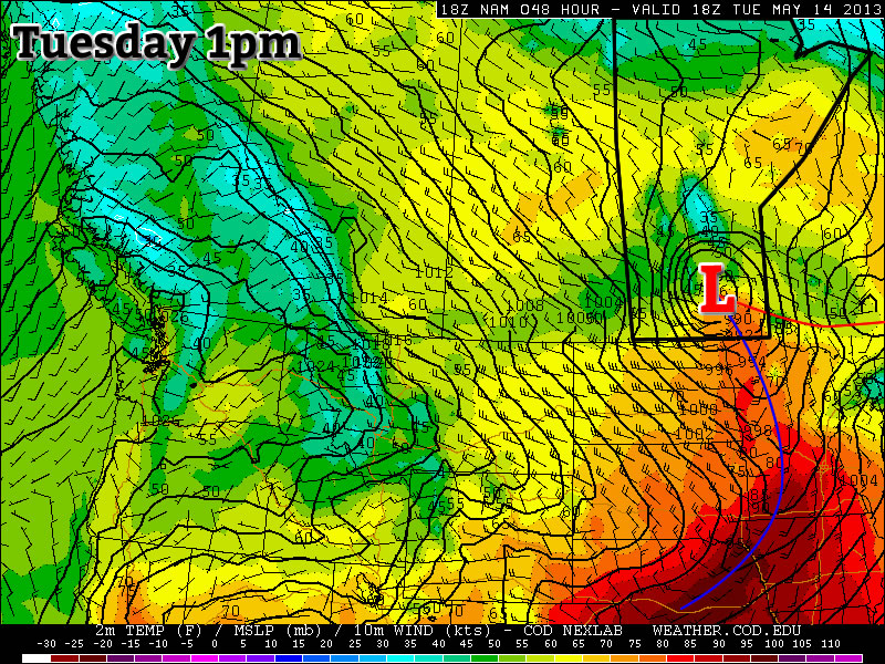
This week will be warm, but somewhat unsettled. A fairly potent weather system will bring rain and possibly thunderstorms to Southern Manitoba on Tuesday.

image

A low pressure system will bring unsettled weather to Southern Manitoba on Tuesday

Monday

Monday
image
Showers in the morning, then becoming Mainly Sunny.
27°C / 13°C

Monday looks to be the nicest day of the week as we potentially experience our warmest day of the year so far. However, before that happens there may be some shower activity this morning along an approaching warm front. Once this front passes skies will clear and temperatures will begin to rise. High temperatures are expected to be in the mid or upper twenties, with skies becoming mainly sunny by the afternoon.

Tuesday

Tuesday
image
Mainly cloudy. Periods of Rain.
20°C / 6°C

Tuesday will be a rather unsettled day in Southern Manitoba. A strong low pressure system will bring rain and perhaps a few non-severe thunderstorms to the southern-most part of the province. The Red River Valley will be in the warm sector of this system in the morning, allowing temperatures to climb up to around the 20C mark before a cold front goes through later in the morning/early in the afternoon. There is a chance we may see some rain or a weak thunderstorm in the morning, but generally speaking the main area of precipitation is expected to pass to our north in the interlake area. Up north of Winnipeg heavy rain will be possible as a stream of moisture is lifted by this system and forms an area of rain. There may be some embedded thunderstorms within the larger area of rain, but they will not be very strong. The Red River Valley may see some wrap around rain on Tuesday night as the area of precipitation over the interlake slumps south. Precipitation amounts from this system will be nearly impossible to predict due to the potential for embedded thunderstorms. In Winnipeg we should see somewhere in the range of 5-10mm, unless a storm goes through in which case we’ll get more. North of Winnipeg upwards of 25mm is possible, but more precise estimates are too difficult to attempt.

Wednesday

Wednesday
image
Mix of Sun and Cloud
20°C / 7°C

Wednesday will see a return to more settled conditions as Tuesday’s system departs. Temperatures will be around the twenty degree mark with a breezy west wind.

Long Range

The rest of the week looks fairly seasonal temperature-wise, with perhaps a chance of light rain on Thursday and/or Friday. A first glance at the long weekend forecast reveals a chance of rain and near seasonal temperatures…but based on past experience, rain on May long weekend is usually a strong possibility…though I probably didn’t need to tell you that!

Lingering Showers Give Way to Unsettled Weekend

A few lingering showers will persist through the Red River Valley this morning as the low pressure system that has been bringing us rain the last couple days slowly pushes eastwards. Conditions won’t improve too much, however, as we’ll be dealing with unsettled weather, albeit a little dryer, through the weekend.

Rainfall accumulations through the day today.

This 12 hour rainfall accumulation map shows the total rainfall that the RDPS model is forecasting for the daytime today.

Showers will slowly taper off through the Red River Valley today from west to east with only a further 2-4mm in rainfall accumulations. This system has brought hugely varying rainfall amounts across the RRV, with general amounts from 20-60mm across the Red River Valley. After spending several months in a row with below-normal precipitation, this system has pushed Winnipeg back to above-normal accumulations for October, which will begin to chip away at our deficit for the year. Winds will also taper off through the day today as we move to a high of only 7 or 8C.

Saturday will be a mainly cloudy day with a slight chance of showers and a high near 11C.

A frontal wave pushes across Southern Manitoba on Sunday, occluded from the parent low that will be captured over Northern Saskatchewan by an upper low in the area. Some uncertainty exists to the amount of precipitation associated with this wave as it moves through. Some models have next to no precipitation, while the GDPS is suggesting as much as 10-15mm of rain. My personal feeling is that we’ll likely see some rain push through with general amounts in the 4-8mm range across much of the RRV. We’ll keep an eye on this system and provide some updates through the weekend in the comments below. Sunday will likely be mostly cloudy again, with a high near 10C.

The biggest weather feature next week looks to be the potential for a significant low pressure system to push into North Dakota, bringing rain, snow, and potentially blizzard conditions to the Red River Valley for the second half of the week. That’s a long ways away, though, and a lot can change between now and then. We’ll be sure to follow this potential system closely through the week ahead.