October Won’t Have a Scary Start

October won’t start off with any scary weather, but I can guarantee the month will end on a frightening note!

Tuesday Will be a Very Windy Day in Southern Manitoba

Monday

Monday

Mix of Sun and Cloud. Chance of Showers Late.
22°C / 8°C

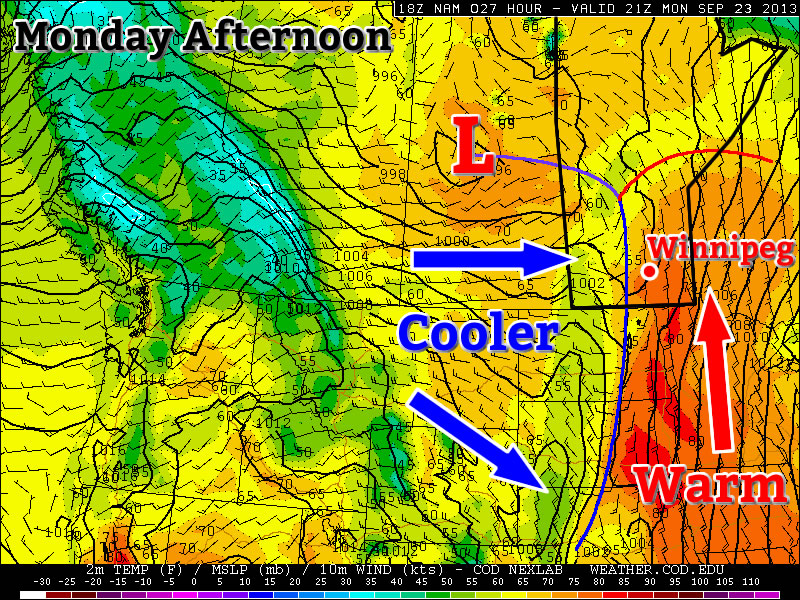
Today will be a nice day in Southern Manitoba. Temperatures will be in the low twenties, under a mix of sun and cloud. The wind will be breezy and from the south-west. A cold front will push through Southern Manitoba on Monday night, setting up a cooler Tuesday. There may also be some light rain showers associated with this front, but it will be a hit and miss type of rain event.

Tuesday and Wednesday

Tuesday

Increasing Cloudiness
17°C / 4°C
Wednesday

Mix of Sun and Cloud
15°C / 6°C

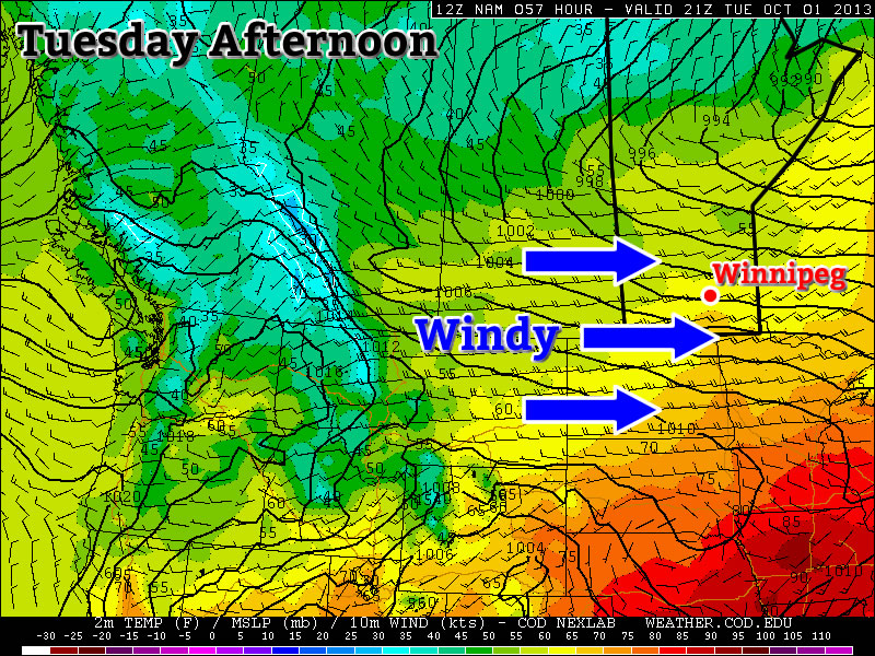
The first day of October will neither be really good, nor really bad. On the one hand it will be a seasonably warm day, with temperatures in the mid to upper teens. However, it will also be a very windy day, with westerly winds of 40-50km/h gusting to 60-70km/h (winds may reach 60km/h gusting to 80km/h on a localized basis). Unfortunately, that strong wind will make conditions much less pleasant than they otherwise would be.

Wednesday looks to be much less windy than Tuesday, but it will still be on the breezy side. Temperatures will be in the mid teens, with a westerly wind of 20-30km/h gusting to 40-50km/h.

Long Range

The long range forecast is looking more October-like. Another cold front is currently forecast to move through Manitoba on Wednesday night, bringing in cooler conditions to end the week. Models are also hinting at a strong low pressure system passing near or just south of Manitoba later this week. Should this system take a more northern track, it could impact Southern Manitoba…but it’s too early to say.

Beautiful Start To Fall Continues

Our beautiful start to fall – a start that has seen two days in a row a full 9–10°C above normal – will continue with well above-normal temperatures continuing through the week. A powerful storm system moving into Saskatchewan will lead to more unsettled weather as we move towards the end of the week, but rain is far from guaranteed here in Winnipeg.

Wednesday

Wednesday

25°C / 16°C
A mix of sun and cloud; windy out of the south.

We’ll see another pleasant but breezy day today under a mix of sun and cloud as some patchy cloud cover moves eastwards from a powerful storm system taking shape over central Saskatchewan. Temperatures should climb to around 25°C this afternoon as gusty winds pick up to 30–40km/h out of the south. The winds will let up a little bit overnight but will still be noticeable which, when combined with increasing cloudiness, will conspire to keep our overnight low around a balmy 16°C – which is coincidentally the average daytime high for this time of year.

Thursday

Total accumulated rain from the GDPS on Thursday 12Z - 00Z.

12 hour rainfall accumluations depicting rainfall during the daytime on Thursday. Under 2mm is forecast by the GDPS for Winnipeg.
Thursday

24°C / 12°C
Cloudy with gradual clearing. Chance of showers midday through the afternoon.

Thursday will bring mostly cloudy skies as the Saskatchewan storm edges eastwards slowly. While showers will push in over Western Manitoba, here in Winnipeg we’ll see just a slight chance of seeing some shower activity. The chance will start midday and last through much of the afternoon, but if we do get any rain it shouldn’t accumulate to anything significant.

The day will start mainly cloudy, but we should see mainly sunny skies by the evening as everything lifts off to the north. Our temperature will climb to around 24°C with winds around 30km/h diminishing through the afternoon. Thursday night will start with mainly clear skies but we’ll see increasing cloudiness by Friday morning as cloud streams in from the southwest ahead of yet another disturbance.

Friday

Friday

18°C / 7°C
Cloudy periods. Very slight risk of a morning shower.

We’ll see some cloudy periods on Friday as another disturbance spreads cloud ahead into Southern Manitoba. Our temperature will be a bit cooler; the daytime high is expected to hit around 18°C as a cold front pushes across the Red River Valley.

Friday night holds some promise of seeing some precipitation, which is rapidly becoming needed in Winnipeg. Only 4mm of rain has fallen in Winnipeg so far this September, not even 10% of the average of 45.5mm that falls in this month. The last significant rainfall in Winnipeg was the heavy thunderstorms that occurred through the morning of Sunday, August 18th which brought 15–30mm to the city. Since then, only 6mm of rain has fallen.

The GDPS is currently the only system that’s bringing rain into Winnipeg on Friday night, however there are some indications that other models could begin to fall in line with that thinking as well. Unfortunately, it’s going to be yet another system that has a very sharp cutoff on it’s edges. This system will be very sensitive to track, so we’ll be sure to keep an eye on things as they develop. Be sure to check back in the comments below for updates closer to the weekend.

Active Weather Pattern, but Inactive Weather?

A couple of weather systems are in store for this week, but that doesn’t mean the forecast is wet for everyone.

A Cold Front Will be Positioned Through Manitoba on Monday

Monday

Monday

Mix of Sun and Cloud. Chance of Showers.
22°C / 8°C

Today will be a warm day by late September standards. High temperatures will be in the low twenties in the Red River Valley. A bit further east in south-eastern Manitoba some areas may approach the mid twenties. But a bit further west in western Manitoba, temperatures will struggle to reach the upper teens. The discrepancy in temperatures over Southern Manitoba today is resulting from a cold front located over western Manitoba. In the vicinity of this front there is extensive cloud cover and some rain activity. Further east, skies are clearer, allowing for the atmosphere to heat up a bit more. Some of the rain showers over western Manitoba may sneak into the Red River Valley later today (as cloudiness increases later today), but little in the way of accumulating rain is expected. Over western Manitoba the rain will probably amount to between 5 and 15mm in general.

Tuesday

Tuesday

Mainly Sunny
21°C / 7°C

Surprisingly, Tuesday will be quite a nice day despite the passage of a cold front on Monday night. High temperatures on Tuesday will be in the upper teens or lower twenties in Southern Manitoba, under sunny skies and light westerly winds.

Wednesday

Wednesday

Mainly Cloudy
22°C / 14°C

Wednesday will see cloudier conditions return ahead of a developing weather system. Temperatures on Wednesday are expected to max out in the low twenties in Southern Manitoba and the wind will be gusty and from the south-east. Some rain may occur over Western Manitoba on Wednesday, but it’s too early to speculate on the location or intensity of it.

Long Range

The long range outlook will be dominated initially be the weather system mentioned in Wednesday’s forecast. This low pressure system is currently expected to track through Manitoba, with its main impacts likely to be confined to the Western half of the province. However, it is possible that this system may change track, so it could potentially affect other parts of Manitoba as well – more details on that will be available in Wednesday’s post.

Once that weather system passes by, conditions should return to near seasonal values for the end of the week. Next weekend is looking fairly pleasant, with near to slightly above seasonably temperatures…but of course that could change before the weekend actually arrives!

Pleasant Second Half of the Week

After some unsettled weather the past couple days, we’ll be seeing pleasant, slightly warmer-than-normal days through the second half of the week as a ridge of high pressure builds into the Prairies.

Wednesday

22°C / 8°C
A few clouds and breezy. Slight chance of isolated late-day showers.
Thursday

21°C / 7°C
Mainly sunny.
Friday

24°C / 12°C
Mainly sunny.

We’ll see a few clouds today with a breezy northerly wind as cooler air moves in behind yesterday’s cold front. We may see some isolated showers late in the day thanks to weak convergence along the western shores of Lake Winnipeg, however they would certainly not be widespread and they would have very limited duration. We’ll see a high of around 22°C tomorrow and we’ll drop down to a chilly 8°C overnight under clear skies.

Thursday will be the coolest day of the week with temperatures topping out only around 21°C and an overnight low dropping down to around 7°C. It may actually end up being one or two degrees colder than that at night depending exactly where the main axis of the surface ridge lines up, but suffice to say it will be quite cool on Thursday night. Winds will be light through the day and we’ll see mainly sunny skies and a clear night.

Outgoing Longwave Flux for 00Z Saturday Sept. 14, 2013 -- approximates cloud cover -- showing a potent low pressure system pushing through the Kivalliq region of Nunavut.

Outgoing Longwave Flux for 00Z Saturday Sept. 14, 2013 – approximates cloud cover – showing a potent low pressure system pushing through the Kivalliq region of Nunavut.

Friday looks to be a fairly nice day as an incredibly potent low pressure system moving through the Kivalliq region of Nunavut into Hudson Bay draws warm air from the Alberta Foothills eastwards across the Prairies. At this point it looks like Winnipeg will get into that warm air and see a high temperature around 25°C, although if the warmth ends up occluding slightly faster, the mid–20’s may be confined to Montana and North Dakota while we remain in the low 20’s. We’ll see a few clouds through the day, but for the most part it should be quite nice with winds out of the south or southwest at around 20km/h. Friday night will cool off to the low teens under clear skies.

A Look Ahead to the Weekend

The weekend looks pretty great at this point. A large ridge of high pressure will move in behind the powerful Arctic low bringing sunny skies, light winds and highs in the low 20’s. Saturday & Sunday nights will be quite chilly, though, with temperatures dipping down into the 4–5°C range, and perhaps even cooler outside the City of Winnipeg. We may end up seeing our first significant risk of frost this weekend depending on exactly how strong that ridge of high pressure ends up being.