A couple of weather systems are in store for this week, but that doesn’t mean the forecast is wet for everyone.
Monday
Mix of Sun and Cloud. Chance of Showers.
22°C / 8°C
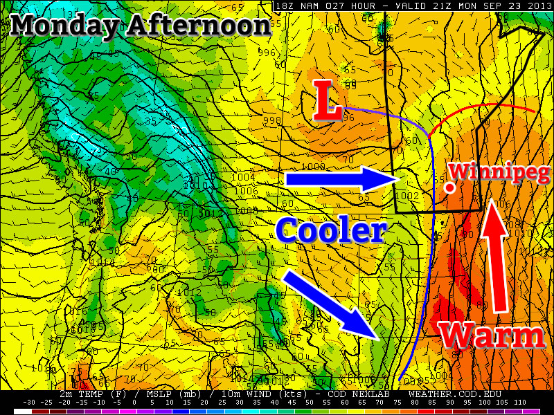
Today will be a warm day by late September standards. High temperatures will be in the low twenties in the Red River Valley. A bit further east in south-eastern Manitoba some areas may approach the mid twenties. But a bit further west in western Manitoba, temperatures will struggle to reach the upper teens. The discrepancy in temperatures over Southern Manitoba today is resulting from a cold front located over western Manitoba. In the vicinity of this front there is extensive cloud cover and some rain activity. Further east, skies are clearer, allowing for the atmosphere to heat up a bit more. Some of the rain showers over western Manitoba may sneak into the Red River Valley later today (as cloudiness increases later today), but little in the way of accumulating rain is expected. Over western Manitoba the rain will probably amount to between 5 and 15mm in general.
Tuesday
Mainly Sunny
21°C / 7°C
Surprisingly, Tuesday will be quite a nice day despite the passage of a cold front on Monday night. High temperatures on Tuesday will be in the upper teens or lower twenties in Southern Manitoba, under sunny skies and light westerly winds.
Wednesday
Mainly Cloudy
22°C / 14°C
Wednesday will see cloudier conditions return ahead of a developing weather system. Temperatures on Wednesday are expected to max out in the low twenties in Southern Manitoba and the wind will be gusty and from the south-east. Some rain may occur over Western Manitoba on Wednesday, but it’s too early to speculate on the location or intensity of it.
Long Range
The long range outlook will be dominated initially be the weather system mentioned in Wednesday’s forecast. This low pressure system is currently expected to track through Manitoba, with its main impacts likely to be confined to the Western half of the province. However, it is possible that this system may change track, so it could potentially affect other parts of Manitoba as well – more details on that will be available in Wednesday’s post.
Once that weather system passes by, conditions should return to near seasonal values for the end of the week. Next weekend is looking fairly pleasant, with near to slightly above seasonably temperatures…but of course that could change before the weekend actually arrives!