Seasonably Mild Conditions Return to Winnipeg

Winnipeg will see temperatures once again climb slightly above seasonal values over the next couple days.

A low pressure system advancing across the Prairies will send temperatures back above freezing in Winnipeg. With plenty of sunshine today, southerly winds will increase into the 30–40 km/h range. The breezy southerlies mark the arrival of a warm air mass, though, and the city should see a near-seasonal high around 0 °C. Some cloud cover will push into the region on Friday night with temperatures heading to a low near -5 °C.

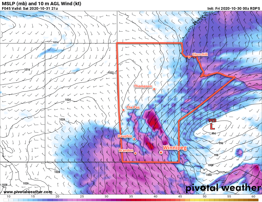
Saturday will bring mostly cloudy skies to Winnipeg as a low pressure system crosses the province. The wind will ease in the morning as the low arrives and temperatures will climb to a high near +2 °C. The low will push out of the region on Saturday evening, ushering in northwest winds of 30–40 km/h with a good chance of some flurries through the night. Temperatures will dip to a low near -6 °C.

RDPS 2m Temperature Forecast valid 21Z Saturday November 14, 2020
A low pressure system crossing Manitoba will bring above-freezing high temperatures back to the Winnipeg region on Saturday.

The breezy northwest winds will persist through much of Sunday, keeping temperatures a bit cooler with a high near -3 °C. Skies will stay mostly cloudy through the morning, but a bit of afternoon sunshine seems likely. While the broader area of flurries will move off, Winnipeg will continue to see a chance of lake-effect flurries until the winds ease off in the evening. The city should see mixed skies on Sunday night with temperatures dipping to a low near -10 °C.

Long Range Outlook

Next week looks to bring variable cloudiness to Winnipeg with his in the -5 to -2 °C range. No notable snowfall events are in the forecast.

Today’s seasonal daytime high in Winnipeg is -1 °C while the seasonal overnight low is -9 °C.

Windy Weather Ahead

Winnipeg’s first effort at milder temperatures will come with plenty of cloud and wind, but sunnier and warmer conditions are likely next week.

Warmer weather will build into the region today ahead of a low pressure system forming over Alberta. Skies should stay mostly cloudy today as the low gathers steam and pushes into Saskatchewan. Temperatures in the city will climb to a high near +2 °C this afternoon. As the low begins moving towards the province this evening, southerly winds will strengthen up to 40 gusting 60 km/h and persist through the night. With cloud cover and moderate southerly winds, temperatures will stay fairly steady with a low near +1 °C.

On Saturday, the low will cross through the province, bringing the warmest air with it. Th wind will ease for the morning with temperatures reaching a high near +4 °C. A potent cold front will sweep through the region midday, ushering in strong northwest winds up to 50 gusting 70 km/h. A chance for midday rain will quickly change to a chance of snow as temperatures drop in the afternoon. The chance of light snow will continue into the evening, then end as a ridge moves into the area. Skies will clear out overnight with temperatures heading to a low near -8 °C.

RDPS 10m Wind Forecast valid 21Z Saturday October 31, 2020
Strong northwest winds will develop over southern Manitoba on Saturday.

Warmer air will already be pushing back into the area on Sunday as a broad upper ridge begins building across the Prairies. The city should see a high near +2 °C with partly cloudy skies. South-southwest winds will pick up through the day into the 20–30 km/h range, then gradually ease overnight. Temperatures will fall to a low near -2 °C on Sunday night under partly cloudy skies.

Long Range Outlook

The upper ridge will continue building across the Prairies through early next week, ushering in a warmer air mass. It looks likely that daily highs may climb up into the 8–12 °C range for a few days, but one unknown is how much low-level cloud the snowpack may generate as the warmer air arrives. In some cases, extensive stratus development can keep temperatures near the surface hovering close to the freezing mark.

We’ll have to wait and see, though, how much of an impact this has. If the winds are able to keep enough of a westerly component to them, they should stay dry enough to scour out any moisture from melting and keep the sun shining through.

Near-seasonal temperatures are forecast to return near the end of the week.

Today’s seasonal daytime high in Winnipeg is 4 °C while the seasonal overnight low is -5 °C.

Colder Conditions Arrive

Today marks the start of an extended period of seasonably cold conditions for Winnipeg.

A low pressure system skirting along the International border will bring cloudy conditions to the Red River Valley today. It will spread an area of rain across the region with up to 10 mm possible along the border. Amounts will quickly diminish northwards, though, with just a bit of light rain likely this morning in Winnipeg. Behind this low, a brisk northerly wind near 30 gusting 50 km/h will develop and usher in a much cooler air mass. Temperatures will only reach around 8 °C today, already several degrees below the seasonal average of 11 °C. The cloud cover will break up a bit tonight as the winds gradually ease. The city will see a low near -3 °C. Hard freezes will be common from here out.

From Thursday forwards, the region will be under a northwest flow aloft on the back side of a persistent vortex over Hudson Bay. This will result in a continued feed of cold Arctic air southwards into the region. Thursday and Friday will bring daytime highs successively colder at +4 and +2 °C respectively. Overnight lows should hover in the mid-minus single digits. Both Thursday and Friday will bring partly cloudy skies to the city and winds will gradually ease from around 30–40 km/h on Thursday to around 20 km/h on Friday. Other than the chance for some lake-effect rain showers or snow in the lee of the lakes — more likely Lake Winnipeg than Manitoba — conditions should stay dry.

Long Range Outlook

The long-range outlook shows nothing but a big vortex entrenched over Hudson Bay. As a result, it also shows nothing but seasonably cold weather for Manitoba. Forecasts show daytime highs locked at the low single digits and overnight lows hovering within a couple degrees of -5 °C.

NAEFS 8-14 Day Temperature Anomaly Forecast — Valid October 21-28, 2020
A stationary vortex over Hudson Bay will bring a prolonged period of cool temperatures to Manitoba. This NAEFS temperature outlook shows a high probability of seasonably cold weather over the province persisting into next week.

The cooler weather towards this coming weekend may end up producing lake-effect snow in the lee of Lake Manitoba in addition to Lake Winnipeg, particularly Friday night into Saturday.

Temperatures may begin to moderate towards seasonal values slightly next weekend (October 24–25), but confidence is low right now.

Today’s seasonal daytime high in Winnipeg is 11 °C while the seasonal overnight low is 0 °C.

Cooler Weather Ahead

Temperatures will slowly drop through the week in Winnipeg as a colder air mass gradually builds into the region.

Winnipeg will see just two more days of near-seasonal temperatures before a pattern shift ushers northerly winds and an Arctic air mass into the region. In the wake of yesterday’s rain, Winnipeg will see mainly sunny skies today. Winds will pick up out of the west to 30 gusting 50 km/h as temperatures climb to a high near 14 °C.

The winds will ease tonight as temperatures dip to around +3 °C. A passing disturbance will bring some cloud to the region overnight. A few showers are possible closer to the U.S. border, but Winnipeg should stay dry through the night.

On Tuesday, westerly winds will strengthen early in the day, up to as high as 40 gusting 60 km/h across the region. Temperatures will reach a near-seasonal high of 12 °C under sunny skies. The wind will quickly die off this evening followed by a low near +3 °C. Skies should gradually cloud over through the night ahead of the next low pressure system approaching the province.

RDPS 2m Temperature Forecast valid 21Z Wednesday October 14, 2020
Northerly winds will begin ushering cooler air into southern Manitoba on Wednesday.

On Wednesday, a low pressure system will dive across North Dakota into Minnesota. In Winnipeg, this system will bring cloudy skies with a chance of rain showers. Winds will also pick up out of the north to 30 gusting 50 km/h in the afternoon. These northerly winds will keep things cooler with a high of only 8 °C. The cloud cover will start to break up overnight as winds ease to northwesterly at 20 km/h and temperatures dip to a low of -3 °C.

Long Range Outlook

Colder weather continues to push southwards through the rest of the week under mixed to cloudy skies. Temperatures will top out near 5 °C on Thursday and drop towards 2–3 °C by the end of the weekend. Overnight lows will hover in the -2 to -5 °C range. A few rain showers (or snow flurries!) may be possible heading through the weekend.

Today’s seasonal daytime high in Winnipeg is 11 °C while the seasonal overnight low is +1 °C.