Today will bring warm temperatures along with a bit of light rain or snow as a Pacific system tracks through the Interlake towards Hudson Bay. Temperatures will climb above 0°C today before they gradually cool down by the end of the week to more seasonal values.
A low pressure system tracking across the extreme Southern Prairies will arc northwards through Southern Manitoba today, lifting northwards through the Interlake region then exiting towards Hudson Bay. This system will intensify as it pushes into Manitoba and precipitation should blossom as it approaches the RRV. Two challenges exist with this system:
- When exactly will the precipitation develop/intensify?
- How far north with the system be?
- What will the phase of the precipitation be, snow or rain?
We’ll likely see some precipitation early this afternoon in the form of snow as the warm front pushes through the RRV. The Western RRV has a risk of some freezing rain if temperatures can stay below 0°C for long enough with this batch of precipitation. Any freezing rain that does develop will be short-lived, though. The snow will likely stop for the short period we’re in the warm sector of this system, but will return by late-afternoon/early evening with some rain or wet snow as the cold front passes through the area. The precipitation will end later in the evening. Snowfall accumulations today should be quite low in the RRV given the warm temperatures, however areas further east in the Whiteshell have a decent chance of getting around 2cm.
Temperatures should reach the 3-4°C range through most areas south of the Trans-Canada Highway today and drop only a little below 0°C overnight.
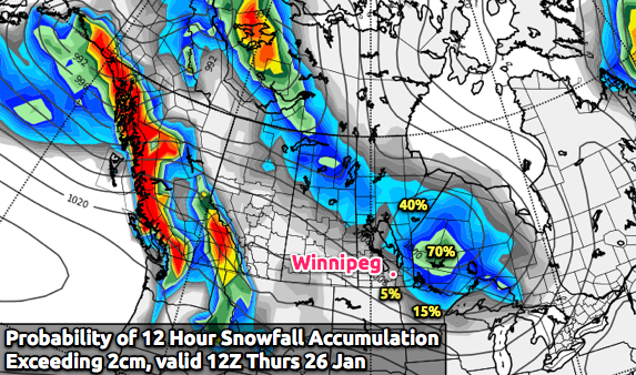
For Thursday, temperatures will reach close to 0°C as an elongated trough moves across the RRV, bringing with it a slight chance of flurries. It should pass by lunch, after which the NW winds will bring in cooler air and drop the temperature slowly through the afternoon.
The rest of the week will be relatively quiet, with temperatures gradually returning to more seasonal values (daytime highs moving from the low minus single digits to the high minus teens). The next chance for significant weather looks to be early next week.
Since it will likely be quiet on the weekend, I plan on having a bit of a special post on Friday! We’ll look at how warm this winter has actually been, and I’ll be unveiling a great new tool (barring no more problems…) that I’m really excited to let everybody get their hands on!