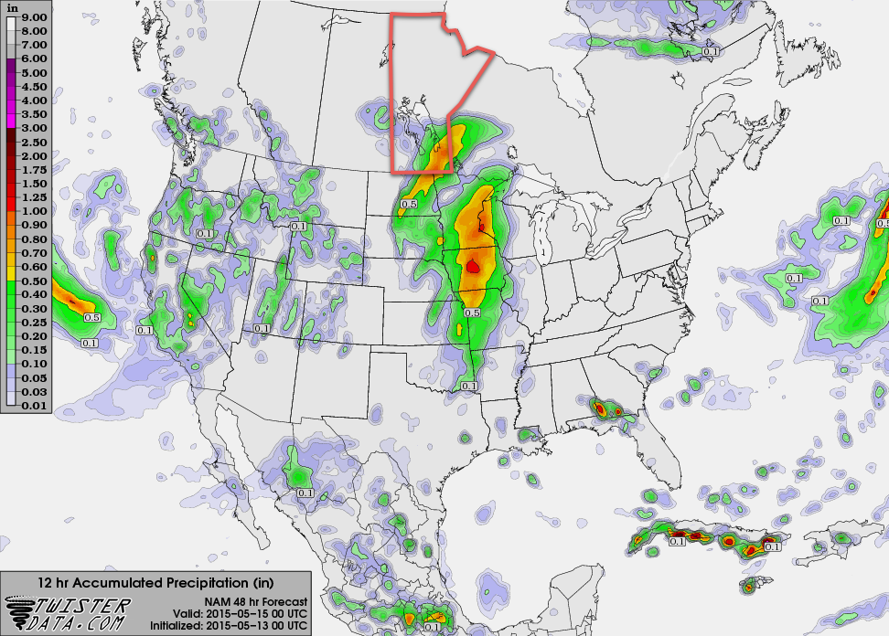
More wet weather is on the way to Winnipeg & the Red River Valley as a slow-moving upper-level disturbance bears down on Southern Manitoba. The bulk of the rainfall associated with this next system will be quite a bit more concentrated than last week’s Colorado Low with much of the precipitation being produced by a single, relatively narrow band of moderate rainfall sliding across the region.
Winnipeg will see a high of around 12°C today with cloudy skies through the day. Shower activity will push northwards through the Red River Valley over the morning hours bringing a decent chance of some rain to Winnipeg by mid-to-late afternoon. Winds will be breezy out of the southeast at around 30km/h with a bit of gustiness on top.
Clouds will stick around tonight as the temperature drops to around 7°C with a continued slight chance of showers through much of the overnight period. The next disturbance will move into Southern Manitoba late overnight, spreading rain from SW to NE starting near the Pilot Mound/SW RRV region and lifting towards Winnipeg.
Thursday will start off as a fairly rainy morning, then see rain taper off from west to east through the afternoon. Skies will remain cloudy through the day with winds out of the east. Expect a high near 13°C. The low on Thursday night will be around 7°C under mainly cloudy skies.
When all is said and done, it’s possible we’ll see somewhere from 10–20mm of fresh rain, however this entire system may end up shifting slightly further west which would leave the Red River Valley fairly dry until remnant showers pass through on Thursday night. We’ll be sure to keep tabs on things as they develop through the day and update with the most likely outcome later tonight.
Friday will bring a break from the gloomy weather as things clear out through the morning, leaving us with sunshine and a high near 19°C and light winds.
Long Range
This weekend will bring another disturbance through the region that has the potential to produce a significant amount of rainfall – 25–50mm – however there’s still a lot of uncertainty associated with the system and many divergent model solutions at the moment. It will likely be a generally unsettled week at best, and potentially a downright rainy one at worst. Some forecasts are showing some fairly favourable convective parameters on Saturday that would hint towards the first significant thunderstorm day of the year, but a decent capping inversion looks to keep things at bay as long as the current forecasts hold out.
Everything is looking on track for the forecast tomorrow with the low now lifting NE through South Dakota with precipitation blossoming ahead of it. The strong lift has already moved over Southern Manitoba, but with little moisture in the mid-levels, the best that the atmosphere has been able to muster has been some drizzle that manages to strengthen to borderline light rain at times.
The system will really wind up through the wee hours of the morning in North Dakota and then spread northwards into the Red River Valley. There’s high confidence that amounts will be significant. The southwest corner of the Red River Valley – Morden, Winkler, Altona, Gretna – will likely be hardest hit with total amounts of 20-35mm. The core of heaviest rain will spread northeastwards through Winnipeg with total rainfall amounts generally in the 15-25mm range. Along the axis of heaviest rain, there’s the potential for various convective elements increasing rainfall amounts; generally speaking, there’s a chance that isolated locations through the Red River Valley may end up seeing total rainfall amounts closer to the 30-40mm range. I should stress that I don’t expect that to be the predominant accumulation, just an outside chance. I’ve attached a 24hr. rainfall accumulation forecast covering the event from the RDPS; I think it does an okay job capturing the relative intensity of the system, although it may be dragging things a little too far west.
Rain will taper off Thursday evening as expected, leaving behind just a chance of some remnant showers overnight.
The Weekend
Looking ahead to the weekend, it still appears that we’ll see another chance of a major soaking across Southern Manitoba. Best indications are for a widespread rain event across much of Southern Manitoba beginning through Saturday afternoon and persisting through the overnight period. Models show lingering showers Sunday morning then drying off on Sunday afternoon. Early indications are for the potential of anywhere from 30-50mm of rain. It’s still early, so we’ll keep tabs on this system as it develops.