This week will start off on a stormy note in southern Manitoba, with a risk of thunderstorms in most areas from today until at least Wednesday. Severe storms will be possible on most days with this risk.
Today
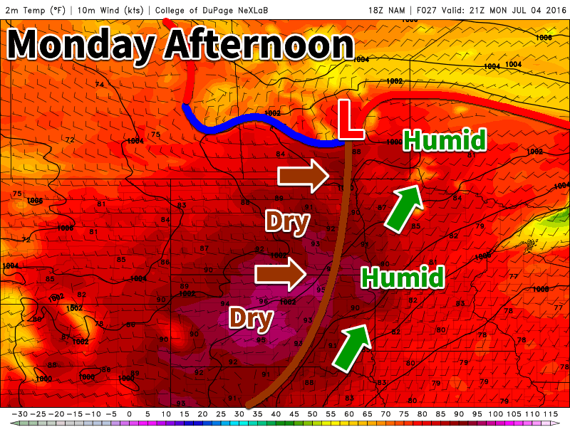
Today will feature a risk of severe thunderstorms in many parts of southern Manitoba due to the warm and humid air mass over the region. It will be a fairly unconventional severe weather setup with a complicated frontal regime in place. It appears that a dryline-type feature will be present through the Red River Valley on Monday afternoon, with a cold front cutting through the southern Interlake. The most unstable air is expected to reside near the cold front and east of the dryline, putting the Red River Valley and south-eastern Manitoba at the highest risk for severe weather. However, a secondary severe risk may develop along the cold front, especially through the interlake. It appears storms could also form further west along the cold front in parts of western Manitoba. The instability regime further west is less certain, therefore the thunderstorm risk in that region is also less clear. Prior to the initiation of thunderstorms, most of southern Manitoba will be quite warm, with temperatures near 30C in many areas. Winds will range from southerly/easterly ahead of the cold front/dryline to westerly/northerly behind these features. A technical discussion using the “MIST” technique is provided below for those wanting more specific details.
Technical Discussion
Moisture: Copious low-level moisture is expected ahead of the triggers today. Surface dewpoints of 20-22C are expected (ET enhancement should be in full swing), with 100-mb mean mixing ratio values of 14-16 g/kg.
Instability: Steep low- to mid-level lapse rates are expected today due to the presence of an elevated mixed-layer (EML) between 925 and 700 mb. These large lapse rates combined with the aforementioned mean mixing-ratio values should result in MLCAPE of 2500-4000 J/kg by late afternoon. MLCIN should be mostly eliminated with surface temperatures near 30C, assuming the 14-16 g/kg mean mixing ratios are realized.
Shear: Deep layer wind shear values will be variable and uncertain today. The 500-mb flow is expected to be 30-40 kt from the west, which would normally offer respectable wind shear on such a convective day. However, surface winds are also forecast to have a strong westerly component, even ahead of the triggers. Since southwesterly winds are expected ahead of the dryline, the effective bulk wind difference (EBWD) is expected to be less than the 500-mb flow. Conversely, some models have suggested easterly winds could be present ahead of the triggers, which would enhance the EBWD. A conservative approach would give an EBWD of 20-35 kt ahead of the triggers tomorrow, with the caveat that an easterly low-level flow could push said values to 40-45 kt. Given the expected westerly-component surface flow, it follows that low-level veering is also expected to be poor. Helicity values in the 0-3 km layer are only expected to be between 100-200 m2/s2, again with the caveat that an easterly surface flow would enhance these values.
Trigger: As mentioned previously, a cold front slicing in from the north is expected to provide a focus for storm develop along and north of the Trans-Canada highway through most of southern Manitoba. A north-south oriented dryline is expected to be in place in the Red River Valley during the day, providing a secondary trigger. Height falls during the afternoon-evening are unimpressive, and indeed could actually end up being height rises. The absence of any strong mid- and upper-level forcing for ascent should help keep storm coverage on the more isolated side, especially given that there will be a respectable, but breakable, cap to surface-based convection.
Discussion: A severe weather setup with impressive thermodynamics, but unimpressive kinematics/dynamics, is expected in southern Manitoba today. A respectable cap will be in place to surface-based convection until late afternoon, at which time strong low-level convergence along the dryline/cold front should be sufficient to trigger isolated severe storms. However, temperatures must reach near 30C for this to happen, therefore if strong surface heating does not occur, storms may fail to develop.
The CAPE-shear space today is sufficient for marginal supercells structures, but stronger supercells are possible should the stronger shear develop (previously discussed). The main threats today appear to be large hail and damaging wind gusts. A few very large hail reports are possible given the extreme instability and steep lapse rates, especially if the stronger wind shear is realized. The tornado threat is marginal given the weak helicity values. However, low-level CAPE and LCL heights are in the tornadic range, suggesting that a right-deviating supercell could produce a brief tornado. The overall risk of severe weather is slight.
Tuesday
Tuesday could see another risk of severe storms develop across southern Manitoba. Models suggest a front may be stalled just north of the international border in the afternoon, providing a focus for storms to develop. Any storms that develop could become severe, with damaging winds and large hail being the main threats. Areas away from the storms should see temperatures in the mid to upper twenties with skies being a mixture of sun and cloud.
Wednesday
A third risk of storms may evolve on Wednesday, though forecasting thunderstorms three days into the future is far from an exact science. Current models show a general non-severe storm risk across southern Manitoba. This means gusty winds, small hail, and heavy rains are the main threats from any storms that develop. Like Tuesday, conditions outside of storms will be nice, with temperatures in the upper twenties and breezy easterly winds.
Long Range
The long range forecast is looking unsettled for the remainder of the week in southern Manitoba. At this time there don’t appear to be any additional threats of severe weather late in the week, but more thunderstorms can’t be ruled out. Looking out further in the long range, models hint at a more sustained period of hot weather as we move into mid-July, although that would certainly not be unusual for this time of year!