Forecast Update: Complicated System To Bring Snow, Lead to Windier, Colder Conditions

As we mentioned in Friday’s forecast post, a major change in the weather is on the way as a potent low pressure system develops in the United States. What Winnipeg can expect to see has become more clear over the past 24 hours, and it looks like the city will see a fresh coat of snow before strong northwesterly winds plunge temperatures well below the values seen over the past week.

Winnipeg will see skies cloud over through the day today, thickening up as the low pressure system in the American Plains spreads cloud northeastwards. Temperatures will reach a high near -1 or 0°C with light winds.

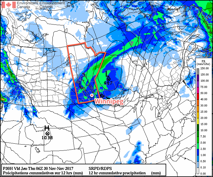
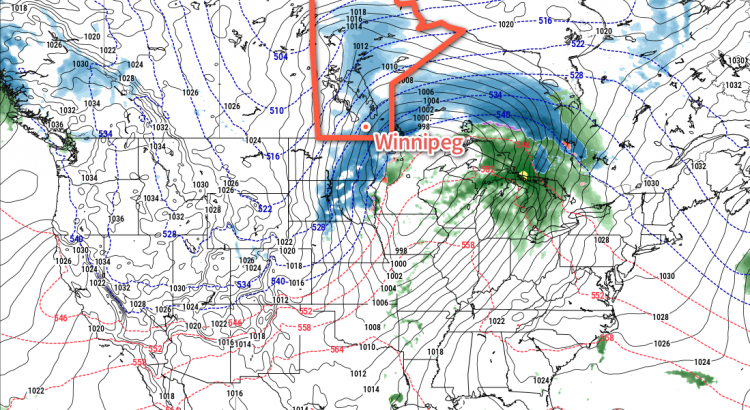
Heading into the evening, snow will spread eastwards across southern Manitoba, slowly intensifying as it pushes towards the Ontario border. For Winnipeg and the Red River Valley, snow will begin in earnest sometime late in the evening and persist for around 6 hours before easing so light snow or flurries. Snowfall amounts will likely end up between 4 and 8 cm…assuming nothing goes to awry with the forecast. To that end, there’s a little bit of disagreement in how the models handle the precipitation; some support it all as a single blob that moves through the region, but others have some along a narrow secondary band that dies out towards the Red River Valley, and more associated with the low pressure system as it lifts northwards out of the United States. Should that second outcome occur, Winnipeg would likely see less snow overall. The other potential problem, particularly for areas close to the US border, is that slightly above-zero temperatures may end up resulting in part of the precipitation falling as rain, which would also [obviously] lead to reduced snowfall amounts.

Monday will bring strengthening northwesterly winds to Winnipeg as colder air begins pushing into the region on the back-side of the low. By Monday afternoon, Winnipeg will see winds of 40-50 km/h out the northwest as temperatures fall towards -6°C. The strong winds will combine with the fresh snow, and possibly some still falling light snow, to produce areas blowing snow.

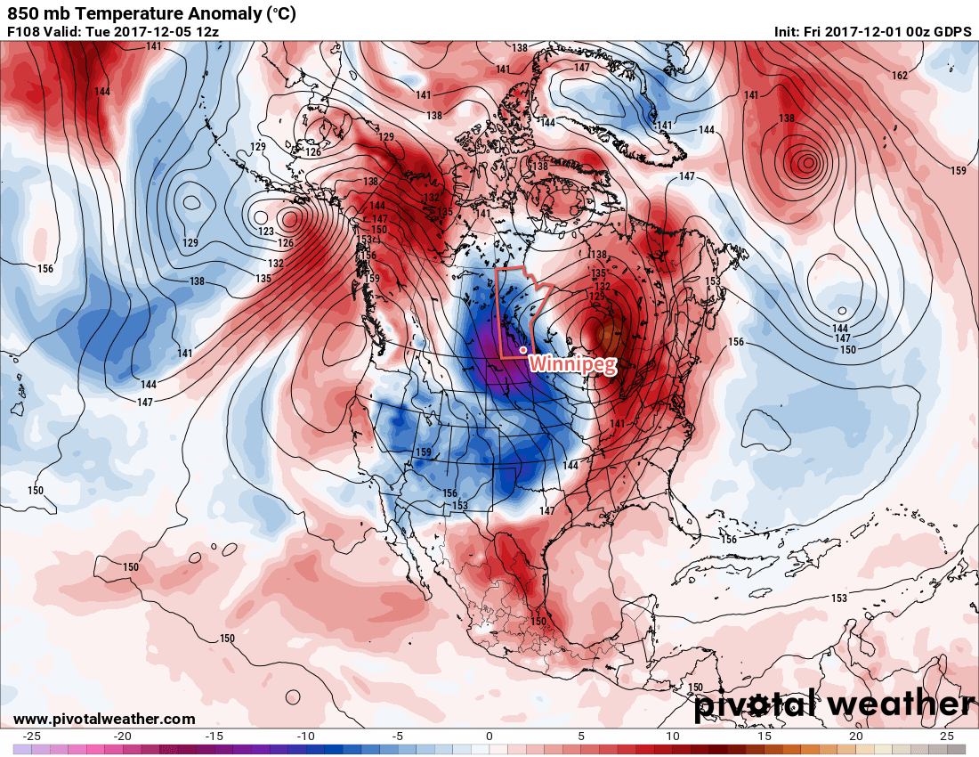
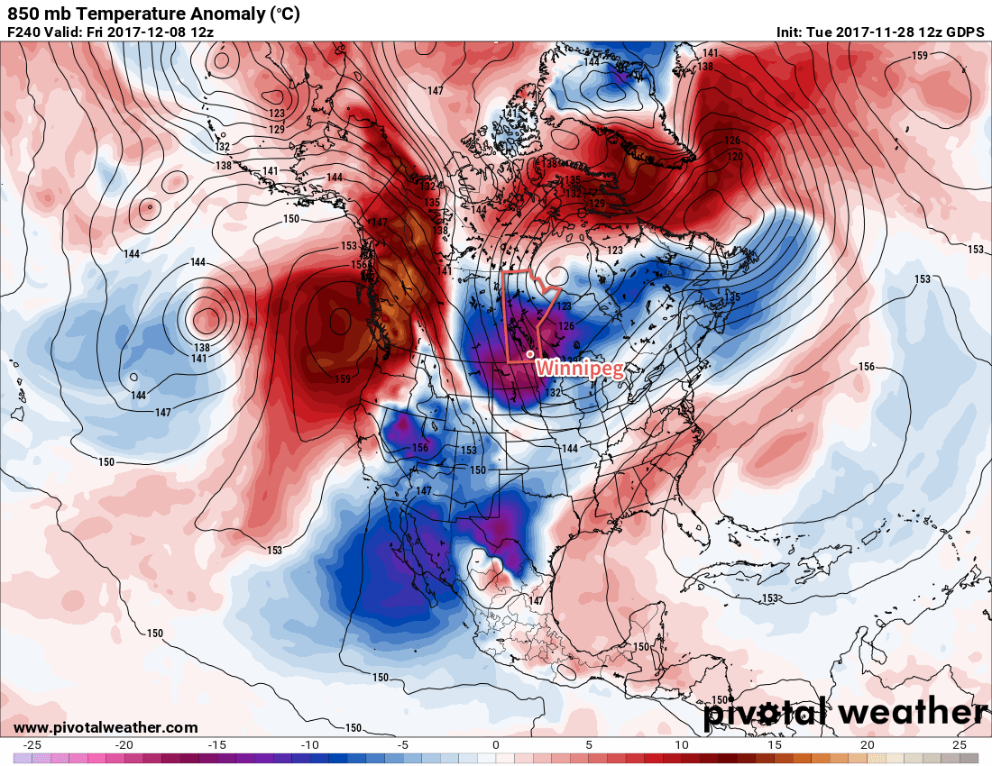
Much cooler weather is on the way for the remainder of the week, with daytime highs falling into the -10 to -15°C range. We’ll have more details on the upcoming week bring and earlier at the usual time on Monday morning! And stay tuned to our Facebook and Twitter feeds this evening for updates as this system finally begins taking shape!

Winnipeg Set For A Mild Weekend, But A Big Cool Down Looms on Horizon

The mild weather Winnipeg has seen lately will last for a few more days, but a low pressure system that tracks across the northern United States on Sunday night will usher in a major pattern change which will allow Arctic air to spill southwards across the Prairies, bringing significantly colder temperatures to southern Manitoba.

Warm, unremarkable weather is on tap for Winnipeg today and tomorrow as a slack flow remains over the region with just a few very weak upper-level disturbances moving through. A weak upper-level disturbance moving into the region will bring increasing cloudiness today as temperatures head to a high near +1°C. No precipitation is expected and winds will remain light. Temperatures will dip down to a low near -7°C tonight with the clouds clearing out by Saturday morning.

Winnipeg will see partly cloudy skies on Saturday with temperatures rebounding to a high near 0°C with light southerly winds. Temperatures will then dip to a low near -6°C on Saturday night with increasing cloudiness.

Everything begins to change on Sunday as a low pressure system develops across the northern Plains of the United States. There’s still a fair amount of uncertainty associated with this low; some models want to keep it relatively progressive and move it through South Dakota, while others develop a more potent Colorado Low that lifts northeastwards towards Thunder Bay. Either way, it should bring mainly cloudy skies to the region on Sunday with a chance for snow moving in on Sunday night. Given the significant uncertainty with this system, an update on what to expect will be posted sometime Saturday evening or Sunday morning.

Long Range Outlook

Without question, the biggest aspect of the long-range forecast is the dramatic cool-down that will occur next week.

By Tuesday morning a much cooler air mass is forecast to be in place over the province

As Sunday’s low pushes eastwards, a large upper-level ridge will build over British Columbia, remaining anchored over the Rockies. A large upper-level trough will develop over eastern North America, bolstered by the incoming low pressure system from the Northern Plains.

This pattern will result in a steady northwesterly flow over the Prairies, setting up an Arctic pipeline that will usher much colder air southwards into the Prairies. It appears that by mid-week, daytime highs in Winnipeg may fall into the mid-minus teens. Another way: by the middle of next week, Winnipeg’s daytime highs may fall to what the seasonal overnight lows are for this time of year.

So, enjoy the mild weather while it lasts, by this time next week it will be a whole lot colder than it is now!

Winnipeg’s seasonal daytime high is currently -7°C while the seasonal overnight low is -16°C.

Another Mild and Windy Day Gives Way to More Cloud And Unsettled Conditions

Mild weather will remain in place for Winnipeg and the Red River Valley, but a pair of low pressure systems will bring plenty of cloud, wind, and some wet weather over the next few days. Better to make the best of it, though, as it’s increasingly looking like Winnipeg may plunge into the winter deep freeze by the end of next week!

Today will bring cloudy skies to Winnipeg as a low pressure system moves into the province from Saskatchewan. Ahead of the low, strong southerly winds of 40-50 km/h with gusts up to 60-70 km/h will develop in the Red River Valley. The winds will increase through the morning, peak midday, then begin to subside through the afternoon. Temperatures will climb to a high near +3°C once the winds ease, but by late afternoon the chance for snow will pick up as a trough swings through the Red River Valley. There’s a chance that early on, precipitation may fall as rain showers instead of snow, but with wet bulb temperatures expected to remain below 0°C, it should switch over to snow as soon as it strengthens to any moderate intensity. The snow will taper off late in the evening, leaving behind a soggy mess as much of it melts on contact. Temperatures will then head to a low near -3°C with northwesterly winds 40 gusting to 60 km/h picking up mid-evening and tapering off overnight.

RDPS Forecast 12hr. QPF valid 06Z Thursday November 30, 2017
A large swath of rain showers and snow will spread across southern Manitoba today

Thursday will bring cloudy skies for much of the day, although some sun might be seen late in the day as clouds begin to clear out late in the afternoon. Winds will be light and gradually shift to southerly through the day as temperatures climb to a high near +1°C. As mentioned before, skies will clear out for Thursday night, leaving Winnipeg with starry skies as temperatures head to a low near -5°C with light winds.

Friday will be another mostly cloudy day as overcast skies move back into the region through the morning. Temperatures will climb to a high near +1°C again with continued southerly winds at 10-20 km/h. Another disturbance tracking across the region will bring a mix of rain changing to snow to Winnipeg sometime in the morning and ending by mid-afternoon. W

Temperatures will dip to a low near -5°C under partly cloudy skies on Friday night.

Long Range Outlook

Mild temperatures will continue through the weekend under variable cloudiness, but a large-scale pattern change next week looks to put the wheels in motion towards an outbreak of Arctic air that would plunge much of central and eastern Canada into a period of below-normal temperatures.

GPDS Forecast 850mb Temperature Anomaly valid 12Z Friday December 8, 2017
The GDPS model is one of the growing consensus that well below-normal temperatures will be in place over the region by the end of next week

Models have growing consensus that over the coming week, a strong upper-level ridge will develop, and remain anchored, over British Columbia. In response to that ridge, a deep upper-level trough is expected to develop in response over eastern Canada, bringing a northwesterly flow to the Prairies that would set up the Arctic pipeline, allowing much colder air to spill southwards. With the growing consensus in the models, it seems like it would be prudent to enjoy the mild weather as much as possible…a more traditional Winnipeg winter may be looming on the horizon.

Winnipeg’s seasonal daytime high is currently -6°C while the seasonal overnight low is -15°C.

Shift to Mild Conditions Brings Cloudy and Unsettled Weather

Winnipeg will see a fair amount of cloud alongside some chances for snow or rain over the next few days, but it’s all in service of bringing in an unseasonably warm air mass that will remain in place for the entire week, making above-freezing high temperatures a common site into the weekend!

Today will bring cloudy skies to Winnipeg as a low pressure system passes through central Manitoba. As the warm front pushes through this morning, there will be a chance of some light rain or, if temperatures haven’t climbed above 0°C yet, some freezing rain – wouldn’t that be wonderful for the morning commute. Unfortunately, as of writing this on Sunday evening, there’s still significant disagreement in the models as to whether or not it will happen and any of the typical signals won’t show up until overnight, making it more of a last-minute forecast. If your plans are sensitive to freezing rain, I suggest you check the Environment Canada forecast for Winnipeg which was updated early this morning. After the warm front moves through, temperatures will reach a high near +4°C in the warm sector with calm winds as a trough of low pressure moves through. A few rain showers will roll through later this afternoon then a cold front will swing through, ushering in moderate west-northwest winds of 40 gusting to 60 km/h. These winds will persist through the night as temperatures head to a low near -3°C.

NAM Precipitation Type/Intensity valid 00Z Tuesday November 28, 2017
Most forecast models suggest Winnipeg and area will see showers move through this evening ahead of a cold front

On Tuesday, a ridge of high pressure will work into the province from the west. As it approaches, winds will taper off and skies will become mixed as temperatures remain roughly near -4°C for much of the day. Skies will clear through the afternoon, and as the sun sets the light winds and clear skies will allow temperatures to drop quite quickly to a low near -7°C, but another warm front approaching will quickly move into the region after midnight, spreading cloud and milder air that will raise temperatures close to -2°C by Wednesday morning.

Wednesday will once again be a cloudy day in Winnipeg as yet another low pressure system tracks through central Manitoba. Temperatures will climb to a high near +2°C with breezy southerlies of 20-30 km/h. A trough will move through in the afternoon, bringing a chance of rain or snow with it. Any remaining precipitation will exit the region by late evening, but don’t expect the weather to get too cold: no big cold push seems evident behind this low! Expect a low near -5°C on Wednesday night with skies becoming mixed.

Long Range Outlook

The remainder of the week continues to look mild, with daytime highs in the 0 to +3°C range and overnight lows near in the -4 to -8°C range. Skies will be variably cloudy, and chances for rain or snow seem minimized until the end of the weekend into the beginning of next week, where a few more systems may move through that bring some precipitation to the region. Enjoy the unseasonal end of November warmth! Perhaps an earned break after the record cold that started off the month!1

Winnipeg’s seasonal daytime high is currently -6°C while the seasonal overnight low is -14°C.

  1. November 9th set new daily record for minimum daily maximum and minimum daily minimum temperatures. Yikes!