Unsettled Weather Continues; Snow Evades Red River Valley

Unsettled Weather Continues; Snow Elusive in Red River Valley

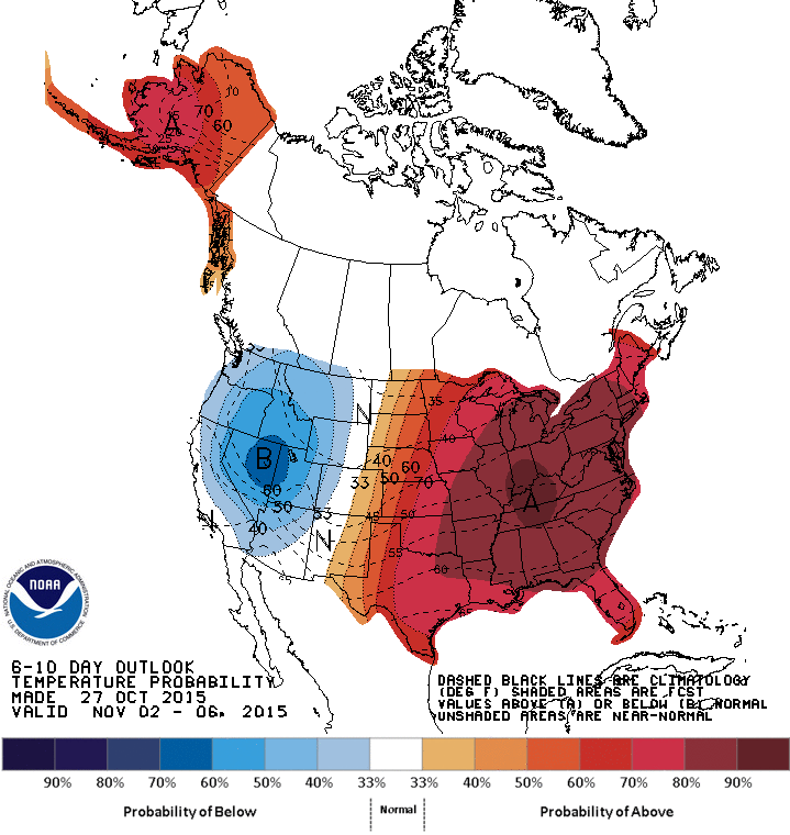
The unsettled pattern that’s been a mainstay of weather chatter since the beginning of the weekend will continue to bring more dreary and wet weather to Winnipeg through the remainder of this week. The upside? Temperatures will continue to remain unseasonably warm for the foreseeable future; not a bad trade if you can handle the absence of sunshine!

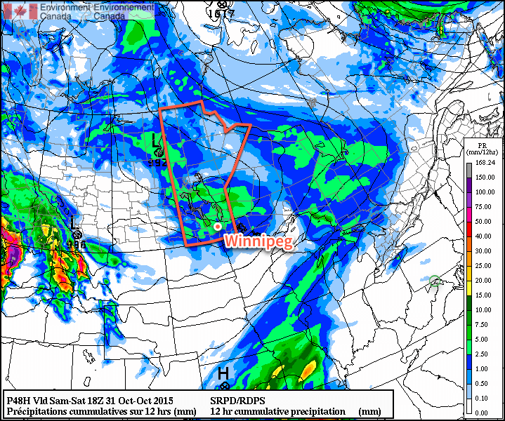
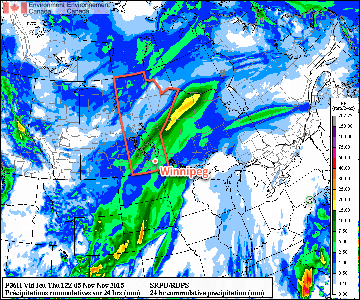
Today will see Winnipeg and the Red River Valley under the influence of a low pressure system moving through the Lake of the Woods region and off into northwestern Ontario. While this system is expected to spread 5–10cm of snow across the Parkland region of western Manitoba, here in the Red River Valley generally light shower or drizzle activity is expected with total rainfall amounts under a couple mm or so. Daytime highs will climb to around the 7°C mark with relatively light winds eventually shifting out of the northwest to 20–30km/h in the afternoon.

RDPS 24hr. Total Precipitation valid at 12Z 05 November, 2015
This total precipitation forecast from the RDPS shows how much precipitation is expected from Wednesday morning through the overnight period.

As we head into the evening, the chance for showers or drizzle will continue well into the evening and overnight period. Total amounts, once again, look quite low. The drizzle and/or shower activity will likely taper off late overnight or early Thursday morning. Expect a low near 3°C.

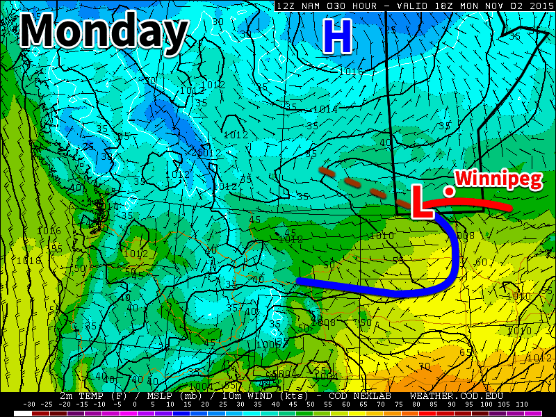
Thursday will be a bit of an unpleasant day as a cooler temperature steady near 4°C combines with brisk northwesterly winds at 30–40km/h as another low pressure system passes by southeast of the Red River Valley. While conditions will be dry through the morning hours, Winnipeg will quite likely see more shower activity push in from the south for the afternoon hours, clipped by the northwestern flank of the area of rain and snow produced by the low moving through.

RDPS 12hr. Total Precipitation valid at 00Z 06 November, 2015
The RDPS, among many other models, is forecasting Winnipeg to be clipped by the northwestern flank of an area of precipitation that will spread across SE Manitoba through the day.

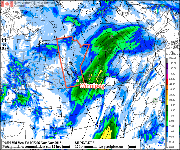
The showers will taper off late in the afternoon and the Red River Valley will head towards an overnight low near –1°C under mainly cloudy skies with diminishing winds.

Friday continues the above-normal daytime highs, and the dreary weather, as mainly cloudy conditions give way to a few scattered showers in the afternoon with northwest winds of 20–30km/h. Daytime highs will sit near 4°C. Friday night will be quite cool with a low near –3°C and, finally, clouds beginning to scatter out.

Mild Weekend Ahead; Sunshine Possible Too!

This weekend looks to continue the above-seasonal temperatures with daytime highs in the mid-single digits and mixed to mainly sunny skies. Saturday might see somewhat windy conditions, however things look quite pleasant on Sunday with little by way of wind, sunshine and a high near 5°C or so. Granted, at this time of year, sunny forecasts can quickly become stratus-filled broken promises, so we’ll be keeping an eye on things as we head towards the weekend.

Dreary Start to the Week

This week will start out on the dreary side as a series of low pressure systems bring rain to southern Manitoba. Some parts of southern Manitoba may even see a bit of snow by midweek.

A low pressure system will bring light rain to parts of southern Manitoba on Monday

Monday

Today will feature mainly cloudy skies and light rain showers as a low pressure system passes through southern Manitoba. Rainfall amounts in the Winnipeg region are expected to be under 2 mm, but areas further north may see slightly higher amounts. Winds will be light and temperatures will be relatively mild (near 10C), so conditions will generally be comfortable outside of the rain showers.

Tuesday

More rain appears to be on tap for Tuesday as we come under the influence of another low pressure system pushing up from the south. Like Monday, accumulations are expected to be small, with amounts of only around 2 mm expected. It will be windier and cooler than Monday though, with temperatures in the mid single digits and breezy north-east winds.

Wednesday

Wednesday will see the continuation of Tuesday’s system with more rain likely in store. Accumulations will probably range from 2-4mm in the Red River Valley. There is a chance of snow in the higher terrain of western Manitoba, but it is too early to say how much could fall. Temperatures will be in the low to mid single digits with a breezy north-west wind.

Long Range

The long range forecast continues to strongly hint at above-normal weather for the first half of November. The combination of a positive Arctic Oscillation and the increasing influence of El Nino will allow Pacific air to continue moving across the Prairies while preventing significant Arctic air masses from surging southward. That isn’t to say we won’t get cold weather this November, but it certainly seems most likely that warmer conditions will dominate. Given that the normal high for this time of year is only 3C, “warm weather” will be a relative term from this point forward.

Milder, Showery Weather on Tap For The Weekend

Milder weather is pushing into the Red River Valley to round out October, making for a comparatively pleasant Halloween evening compared to some of the years past. There will be several chances for precipitation, though, as the same pattern that is bringing the warmer weather to our region will also bring several disturbances rippling through as well.

Today will be a fairly pleasant day for Winnipeg & the Red River Valley as temperatures begin to climb above seasonal values thanks to a warm front pushing eastwards through the province. Here in Winnipeg, temperatures should climb to around 9°C under mixed to mainly cloudy skies with winds increasing out of the south to around 30km/h. There will be a very slight chance of a shower this afternoon, although for the most part, it looks like things should stay north of the city.

RPDS Precipitation Forecast for October 31, 2015 (12hr. Cumulative)
The RDPS is forecasting around 2-5mm of rain for the Red River Valley on Saturday

Skies will clear this evening and temperatures will dip to a low near 3°C. More clouds will begin pushing in overnight as a low pressure system moves towards the province from Alberta.

Rainy Halloween Clears Out In Time For Trick or Treating

Saturday will be off to a cloudy and rainy start as an area of showers moves into the region alongside a low pressure system moving through. The cloud and showers will stick around through much of the morning and into the afternoon before finally tapering off sometime mid-to-late afternoon. Winds will start out of the south at around 20km/h, shift to the west-northwest late in the afternoon to 25–35km/h, and then diminish overnight.

The high temperature will be around 10°C. Total rainfall expected will be low at just a couple of mm.

Conditions for trick or treating will be great this year. There may be a few showers lingering around late in the afternoon or early in the evening, but they should clear out fairly quickly in the evening. Temperatures will be mild, hovering between 8–10°C through much of the evening, while the winds will be a bit breezy from the west, but diminishing as the evening wears on. All in all, it will be quite a pleasant evening!

More Showers Possible Sunday

Sunday will see another chance for shower activity, thanks to a low pressure system zipping along the international border. It will be another mainly cloudy day with highs near the 10°C mark and relatively light northeasterly winds for much of the Red River Valley. Precipitation amounts are expected to be fairly minimal, so despite the somewhat gloomy-seeming forecast, it could end up being a relatively pleasant day, especially considering that we’re talking about +10°C highs in November!

Daylight Savings This Weekend

Just a friendly reminder that this weekend we set our clocks back an hour! Daylight savings time ends this Sunday, November 1st at 2AM, so remember to set your clock back an hour on Saturday night before you head to bed!

Chilly Mid-Week, Gradual Return to Above-Normal Temperatures

Today will be off to a chilly start as rain showers or flurries move through the Red River Valley alongside near-freezing temperatures and a gusty northwesterly wind. Fortunately, this brief outbreak of colder weather will be short-lived as above-normal temperatures gradually build back into the region for the weekend.

Cool & Soggy Wednesday

It will be cool and soggy today for Winnipeg & the Red River Valley as a brisk west to northwesterly wind carries flurries & showers through the region. Much of today’s precipitation will fall as rain, however for several hours this morning snow will be possible. No significant accumulations are expected since temperatures (and the ground) will be above zero, but it could be enough to dust grassy areas and cars.

Temperatures will be below-normal today with the high temperature topping out at just 6°C.

RDPS 12hr QPF valid for 00Z Wednesday October 28, 2015
RDPS 12hr precipitation totals valid for 00Z Wednesday October 28, 2015

The wind will be out of the north to northwest for much of the day at around 30km/h with some gustiness on top of that, however as an inverted trough passes through late in the afternoon & the pressure gradient straightens out, winds will increase to 40–50km/h this evening for several hours before tapering off as a ridge of high pressure pushes in overnight. Temperatures will drop to around 2°C overnight.

Warming Trend for Second Half of the Week

Thursday and Friday will be slightly more pleasant days with temperatures gradually returning to seasonal values. Both days will see a fair amount of cloud through the Red River Valley, although Thursday has the potential for a few more sunny breaks than Friday does. Daytime highs will be just above the seasonal value of 6°C on both days with a high of 7°C expected on Thursday and a high of 9°C on Friday. No precipitation is expected on either day and overnight lows will sit near the freezing mark both Thursday & Friday nights.

Well Above-Normal Temperatures Return for the Weekend

Snow suits will be absent for Halloween this year as temperatures some 6°C above normal will result in a relatively mild end to October.

CPC 6-10 Day Temperature Outlook
The Climate Prediction Center’s 6-10 day outlook is predicting a fair chance for above-normal temperatures early next week.

Daytime highs in the low teens are expected this weekend and into the beginning of next week thanks to a broad zonal flow that will develop aloft, keeping the colder Arctic air in the north and spreading milder Pacific air across the southern Prairies.

There’s a bit of uncertainty as to precipitation; most models show a dry weekend ahead, however the GFS wants to push a disturbance through midday Saturday bringing a shot of rain to the Red River Valley. We’ll keep an eye out as that situation develops and be sure to have a complete Halloween evening forecast in our Friday forecast. Other than that, it does look like we’ll head into a more unsettled pattern next week, with potentially the first “real” snowfall of the season, so enjoy the coming mild weather while you can!