GDPS 2m Temperature Forecast valid Tuesday November 26, 2019 (Image courtesy Pivotal Weather)

Cooler and Cloudier Weather Ahead

Winnipeg will see plenty of cloud through the first half of the week as temperatures gradually return to seasonal values.

Winnipeg will see cooler weather move into the region over the next few days, pushing south behind the disturbance exiting the region this morning. An upper low over the central Prairies will block any potential for an Arctic blast, though. Instead, there will be plenty of cloud cover with occasional flurries as temperatures slide to seasonal values.

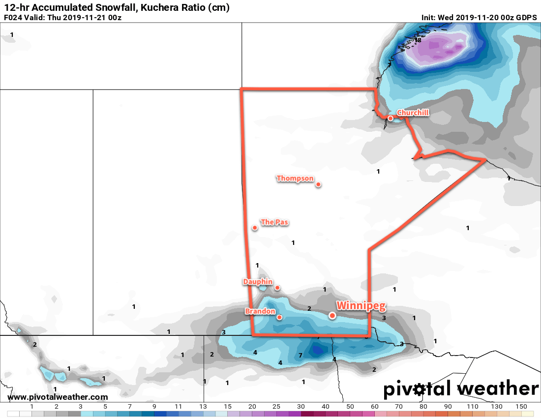
Today, Winnipeg will see the snow taper off with a few flurries lingering. Temperatures will over around 0 or -1°C through most of the day with winds picking up out of the north to 30 gusting 50 km/h. The wind will taper off this evening as the city heads to a low near -6°C under mostly cloudy skies. There will be a chance of flurries through the night.

The city will see plenty of cloud on Tuesday, but a few sunny breaks are possible. Temperatures will climb to a high around -3°C and winds will be light. With the upper low in the vicinity, the city will continue to see a chance for a few flurries. Winds will pick up light out of the northeast on Tuesday night as Winnipeg heads to a low near -7°C. Skies will stay cloudy with…a chance of flurries.

Skies will again stay mainly cloudy on Wednesday with what looks like a good chance for some flurries. The high should be around the -5°C mark with a light northerly wind. Mostly cloudy conditions will continue Wednesday night with a low near -10°C.

Long Range Outlook

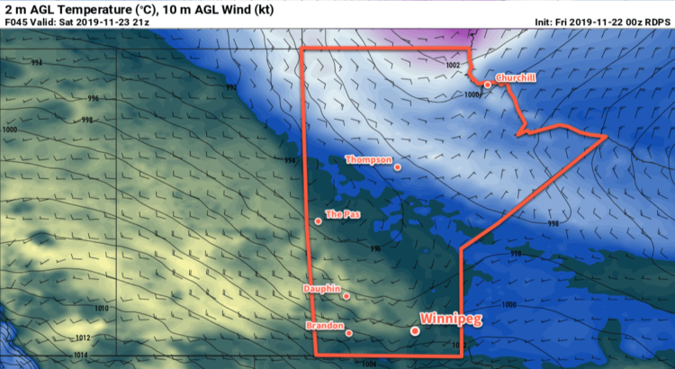
Unfortunately, the sun doesn’t look like it will make much of an appearance through the second half of the week, either. Another disturbance is forecast to move through on Thursday night, likely bringing another 2 to 5 cm of snow to Winnipeg and area. Temperatures will continue to hover around seasonal values into the weekend.

The sun is forecast to make a reappearance heading into Saturday and Sunday, but cooler conditions will push in to start next week, sending daytime highs below the -10°C make.

Today’s seasonal daytime high in Winnipeg is -5°C while the seasonal overnight low is -13°C.

RDPS 2m Temperature Forecast valid 21Z Saturday November 23, 2019

Mild Weekend Ahead

A surge of Pacific air will sweep across southern Manitoba today, ushering in milder temperatures for the weekend.

The cooler conditions that settled in behind Wednesday’s snow will be kicked out today as mild Pacific air moves in. The push of warmer air will bring mainly sunny skies and southerly winds near 30 gusting 50 km/h to the region. Temperatures will climb back towards the freezing mark, but the new snowpack will likely keep temperatures from rising much further. Winds will ease this evening as Winnipeg heads to a low near -5°C tonight under partly cloudy skies.

Winds will shift southwesterly on Saturday as another surge of warm air pushes eastwards. As the winds strengthen into the 20 to 30 km/h range, Winnipeg will see temperatures rise to a high near +2°C under mixed skies. Winds will gradually ease overnight and temperatures will dip to a low near -2°C under partly cloudy skies.

Cloudy conditions return for Sunday as a low pressure system moves into the region from the northwest. Winds will stay light as temperatures climb back to a high near +1°C. A wintery mix of precipitation is possible after dark as the low moves into the Red River Valley, but mild temperatures will limit snowfall accumulations. Temperatures will likely hover close the freezing mark through the night.

Long Range Outlook

Temperatures will gradually cool through the first half of next week back to seasonal values. Conditions will be fairly pleasant, though, with light winds and variable skies. Indications are that cloud will return for the latter half of the week with the potential for some more snow through the region.

Today’s seasonal daytime high in Winnipeg is -4°C while the seasonal overnight low is -12°C.

Snow Ushers in Cooler Conditions, But Mild Weather Returns For The Weekend

Southern Manitoba will see snow today and northwest winds that usher in cooler temperatures for Thursday. The dip in temperatures will be short-lived, though, returning to seasonably mild values on Friday.

A disturbance tracking along the international border will spread light snow across southern Manitoba this morning. The snow will taper off to flurries through the afternoon, leaving behind 2 to 4 cm in Winnipeg and 5 to 10 cm closer to the U.S. border into southwest Manitoba. Temperatures will hover near the -3°C mark through the day with northerly winds of 20 to 30 km/h.

The winds will persist overnight out of the northwest ahead of an Arctic ridge moving through Saskatchewan. Temperatures will dip to a low near -11°C with some of the cloud cover breaking up overnight.

GDPS 12hr. Snow Accumulation (using Kuchera SLR) valid 00Z Thursday November 21, 2019

Thursday will bring mixed skies to the region as the ridge gradually moves into the Red River Valley. Breezy northwest winds of 20 to 30 km/h will keep temperatures cool through the day; Winnipeg will see a high near -8°C. The wind will taper off for the evening, leaving the region with light winds and mostly clear skies for the night. Temperatures will dip to a low near -10°C on Thursday night.

A warm front pushing through early Friday will spread milder air back into the region. Southwesterly winds will pick up to around 30 km/h for the afternoon, sending temperatures to a high near 0°C. Skies will be partly cloudy through the day. Temperatures will dip to a low near -4°C on Friday night with winds easing a bit and shifting westerly.

Long Range Outlook

A [mostly] zonal flow aloft will keep temperatures mild with variable cloudiness right into next week. The main storm track will sit across the northern Prairies and keep things further south dry. The pattern will begin to break down next week as an upper low moves into the Prairies and begins spreading cooler air southwards.

Today’s seasonal daytime high in Winnipeg is -3°C while the seasonal overnight low is -11°C.

RDPS 2m Temperature Forecast valid 21Z Monday November 18, 2019

Pleasant November Weather Ahead

Mild weather continues in Winnipeg with only a brief cool-down in the latter half of the week.

A series of low pressure systems passing through the Prairies will maintain seasonably mild temperatures to start the new work week. Winnipeg will see a mild start to the day with temperatures near freezing climb to a high of +3°C this afternoon. Moderate southerly winds near 30 km/h will ease through the morning, followed by light winds for the afternoon as a trough moves into the Red River Valley. Skies will be mainly cloudy but a few sunny breaks are possible, particularly midday into the early afternoon. The cloud cover will thicken up later in the day with a chance of rain showers through the evening hours.

Skies will stay cloudy overnight with light westerly winds. Winnipeg should see a low near 0°C.

Tuesday will bring cloudy skies to the city with light west-northwest winds as a low spins its way into northeastern Manitoba. There won’t be much going on weather-wise; Winnipeg will see a high near +2°C and cloud. A cold front will push into the region on Tuesday night, keeping skies cloudy and bringing a chance of flurries to the region overnight. Winnipeg will see a low near -4°C.

Cooler air will continue streaming southwards on Wednesday, bringing with it cloudy skies with the chance of flurries. Winds will persist out of the northwest at 20 to 30 km/h while temperatures hover around -4°C. The cloud cover will begin to break up overnight as temperatures head to a low near -10°C.

Long Range Outlook

A cooler air mass will be in place over the region on Wednesday, bringing high temperatures in -5 to -10°C range. Fortunately, the cool-down will be short-lived with highs back near the freezing mark returning on Friday and persisting through the weekend.

A longer stretch of mild temperatures near the freezing mark should persist through the middle of next week with variable cloudiness and no notable rain or snow events. Time to enjoy a pleasant stretch of weather heading into the end of November!

Today’s seasonal daytime high in Winnipeg is -3°C while the seasonal overnight low is -10°C.