Temperatures Plummet for Weekend Arctic Outbreak

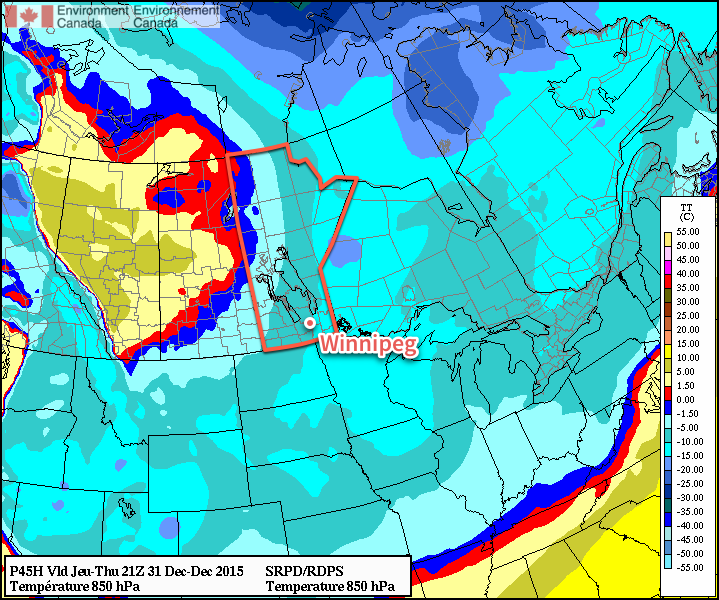
Winnipeg will be re-introduced to winter this weekend as a major pattern shift will usher in one of the coldest outbreaks of the season as bitterly cold air surges out of the Arctic and plummets much of North America into below-normal temperatures.

The next few days will see Winnipeg socked in under extensive cloud cover. While the lack of sun will be a little disheartening, the thick blanket of cloud will moderate temperatures substantially, staving off the cold weather for a little longer.

Both today and tomorrow will be mainly cloudy days with daytime highs around -7 or -6°C and overnight lows in the -10 to -12°C range. A weak ridge of high pressure anchored through the region over the coming days will also keep winds fairly light. All in all, it looks like a relatively pleasant couple of January days.

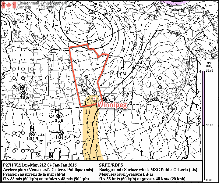
On Thursday night, a disturbance rippling through the region aloft will help deepen an inverted trough extending to the north-northwest from a low pressure system moving through Iowa. These two things combined will help support an area of light snow that will spread across the province from central Saskatchewan.

AWM Snowfall Forecast for January 7-8, 2016
A large area of light snow is expected to move thorugh the Red River Valley on Friday. Heavier snow is expected through east-central Saskatchewan into Swan River & Dauphin.

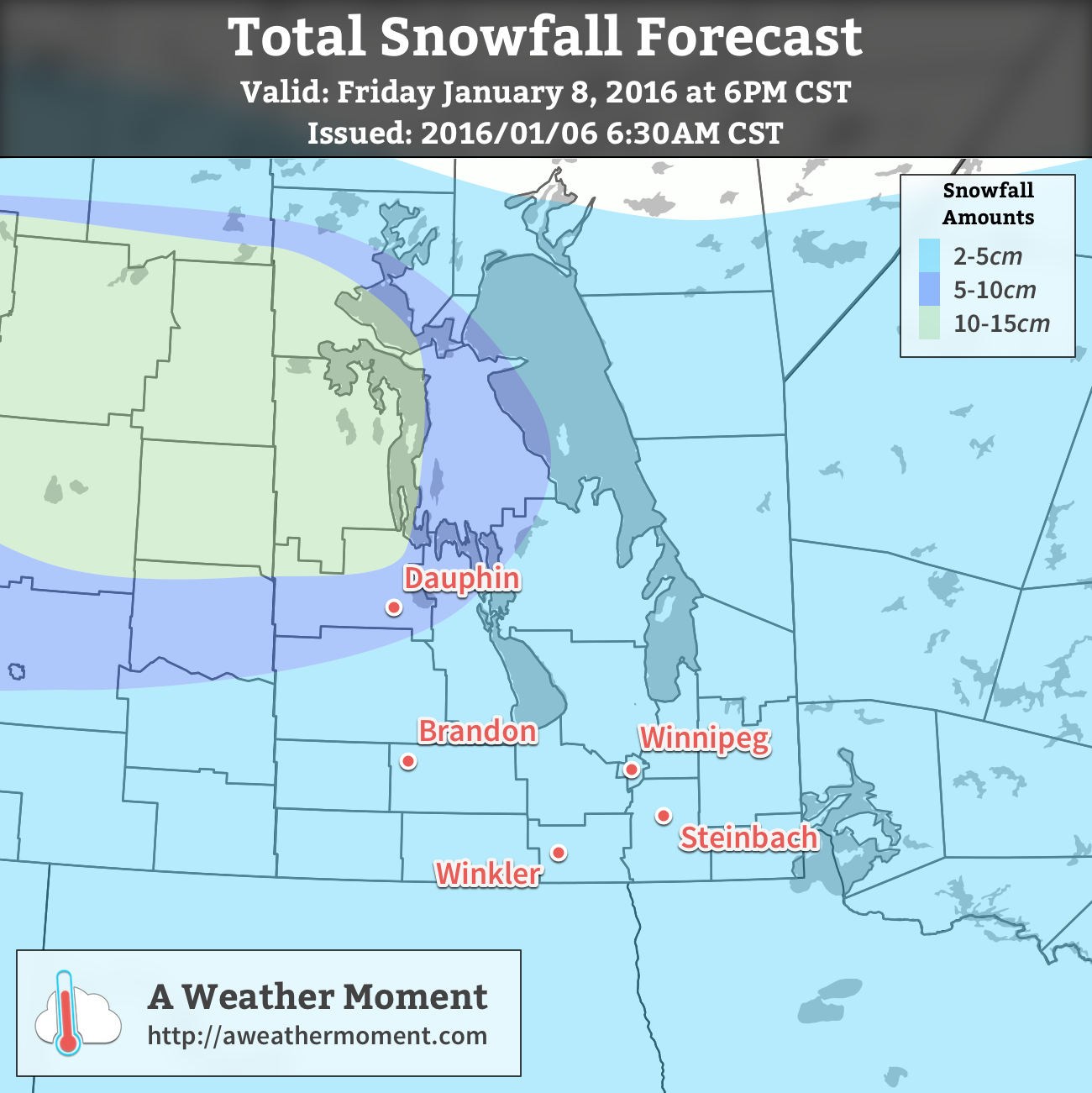
Snow will begin through Thursday night from west to east and will be fairly light, with just 2-4cm total accumulation expected by the time it tapers off on Friday afternoon.

Temperatures will be fairly steady throughout the snowfall on Friday, either remaining near Thursday’s overnight low or perhaps recovering just a degree or two. As the snow tapers off in the afternoon, gustier northwesterly winds will build into the region—at this point it looks like they’ll be around 30km/h—and begin ushering in colder air.

Skies will clear on Friday evening allowing temperatures to plunge to about -21°C by Saturday morning.

Long Range: Cold Weekend

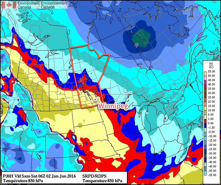
This weekend will see bitterly cold weather settle in over the province as the core of the coldest air on the continent rotates over the region. [1]

GDPS 850mb Temperature Forecast valid Saturday 12Z 09 January 2016
The GDPS 850mb temperature forecast shows the core fo the coldest air on the content rotating into Manitoba.

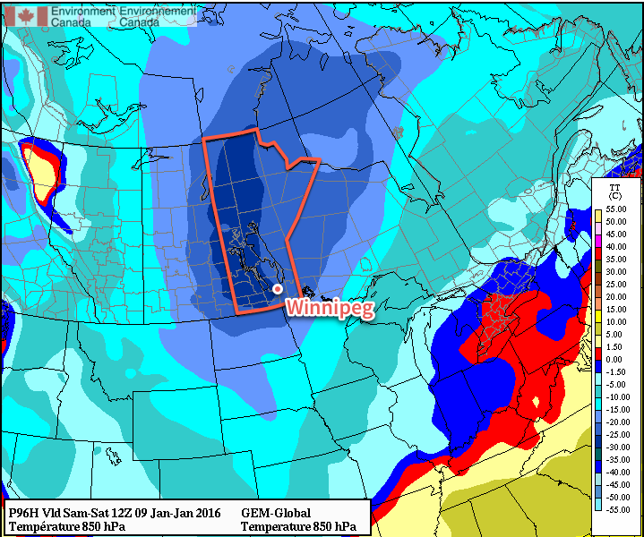
This very cold air mass will result in temperatures steady near around -20°C on Saturday, but quickly dropping into the lower -20’s on Saturday night. Sunday will likely see a high near -21 or -22°C with temperatures remaining fairly steady on Sunday night as some warmer air begins working into the region. Skies will be mainly clear through the weekend with little wind.

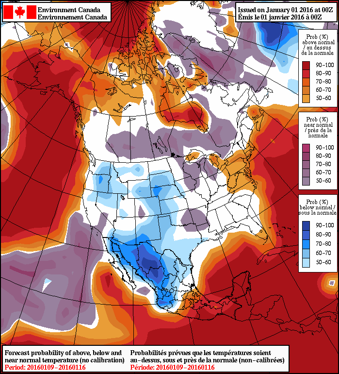
Looking further ahead into next week, near-seasonal temperatures to slightly below-seasonal temperatures are expected. Seasonal highs are near -13°C for this time of year.


  1. Some may wonder why the coldest air mass on the content won’t result in the coldest temperatures on the continent, and the answer to that is complicated. The most basic reason is simply that compared to our Arctic neighbours, we actually have sunshine at this time of year. There are a host of other reasons, too, rooted in prior conditions.  ↩

Mild Start of Week but Change is Coming

The temperatures look to remain above average for the start of this week as the storm track remains well to our north, and the cold Arctic air remains locked up to our north….for now.

Although today will be fairly warm, with a high near -5°C, the wind will be a factor in making it feel cooler than it actually is. Sustained southerly winds could reach 40km/h, with gusts in the 60km/h range tomorrow, in the afternoon and evening. The overnight low will be a fairly mild one, with temperatures only dipping to around -12°C.

RDPS Forecast Winds for Monday Afternoon
The RDPS forecast shows a core of strong outflow winds running across the Northern Plains and through the Red River Valley into Manitoba on Monday afternoon.

Tomorrow looks to be more of the same temperature-wise, with temperatures reaching -6°C. The strong winds should ease up early in the morning – only reaching 10-15km/h on Tuesday. Skies should remain partly cloudy throughout the day, but overnight cloud cover will increase, associated with a system to our south.

On Wednesday cloud cover is expected to persist and even a few flakes are possible in the morning and early afternoon, but amounts won’t be significant. The high looks to be slightly cooler than previous days at around -8°C. North-easterly winds will be in place through the day but they won’t be very strong; only around 10km/h or so.

Long Range

Long range models are hinting at a possible snow event at the end of this week. Right now models show the bulk of the snow staying to the southeast of Winnipeg, into northwestern Ontario though. Unfortunately, cold Arctic air will be advected into our region behind this system, resulting in normal to below normal temperatures by the weekend.

2016 Kicks Off With Mild Weather

Winnipeg will be ringing in 2016 with temperatures 5-10°C above normal as a surge of mild Pacific air sweeps across the Prairies.

A gorgeous holiday Friday and weekend is on tap for Winnipeg thanks to a surge of warmer air that swept into the province overnight. Today will bring mainly sunny skies and breezy westerlies at 20-30 km/h. Temperatures will climb to around -4°C for the afternoon with a chance of some cloudiness as a bank of stratus cloud passes mainly to the east of the Red River Valley. Winds will persist out of the west-northwest at about 20 km/h as temperatures dip to to around -10°C.

Tomorrow will bring some afternoon cloud as a weak cool front approaches, but not before temperatures climb to the -3 or -2°C mark! At this point, it doesn’t look like there will be too much cloud on Saturday afternoon as once again, the main area of cloud is forecast to pass east of the Red River Valley. Temperatures will dip to around -12°C on Saturday night before moderating slightly as cloud cover begins building into the Red River Valley.

RDPS Forecast 850mb Temperatures valid 06Z Saturdy Morning
A significant push of warm air sets up over the Red River Valley for Saturday, shown here via the forecast 850mb temperatures.

Sunday looks like the weather takes a bit of a turn for the worse, but the mild weather persists. The cloud that will be tied up to our east over the next couple of days is forecast to finally spill westward and push into the Red River Valley. With that happening, it looks like Sunday will be mainly cloudy, but still mild for early January, with a high near -7°C. The cloud will keep things warm on Sunday night with a low near -10°C.

Long Range

Conditions will remain mild through the week with daytime highs in the -5 to -10°C range. No significant precipitation is expected until possibly the end of the week, so all in all it’s looking great!

NAEFS 8-14 Day Temperature Anomaly Outlook
NAEFS 8-14 Day Temperature Anomaly Outlook valid January 9-16, 2015

In the longer range, models are converging on seasonal temperatures for the region. This would mean occasional snow and highs in the -10 to -15°C range and lows between -20 to -25°C.

Big Warm-Up to Start the New Year

While the cold snap that settled into Winnipeg for Boxing Day was incredibly short-lived with temperatures returning to seasonal values just 3 days later, that didn’t stop many from wondering where the nice weather went. Good news for those that didn’t want to even deal with a few days of (relatively easy-going) Winnipeg winter: a big warm-up is on the way for the start of 2016.

The weather today and tomorrow will be defined by the passage of a slow-moving upper-level low pressure system that is tracking through North Dakota. This system will spread plenty of cloud across Southern Manitoba, some will be higher-level cloud, while there will also be low-level cloud that will have fog patches along its edges and some light flurry activity under it. The sun may make a few appearances through the day, but overall it will be mainly cloudy.

Temperatures will be fairly similar both today and tomorrow with daytime highs of -9 and -8°C and overnight lows both nights around the -12 or -13°C mark.

Thursday will bring a bit more sun than Wednesday and less chance of any flurry activity.

Forecast 850mb temperatures for Thursday afternoon from the RDPS
The 850mb temperature forecast from the RDPS clearly shows the surge of warm air pushing into the Prairies on beginning Thursday.

By Friday, the warm air begins surging over the province. The set-up for this delivery of warmth is a rather odd one; over the past couple days, an upper-level ridge has been building northwards over the B.C. coast, pushing warm air into Alaska and the Yukon. This upper-level ridge is forecast to spill eastwards over the Rocky Mountains and then build into the Central Prairies. This will release the built up warmth over the western Arctic and allow it to spill southeastwards across the Prairies. It’s certainly a rarity that Winnipeg sees warm advection in a northwest flow, especially in January of all months. The leading edge of the warm air should help temperatures climb to around -5 or -4°C with a bit of a westerly to northwesterly breeze. Skies should be fairly clear for the most part. Expect temperatures to dip down to the low minus-teens again on Friday night.

Long Range

Warm weather should persist through the weekend. A brief shot of cooler air on Sunday night could result in a few flurries on Sunday morning, but no significant snowfall is expected. Daytime highs through the weekend will likely sit near -3°C, although if everything were to happen perfectly, then a high near 0°C could be possible. Saturday looks mainly sunny at this point, while a bit more cloud is in store for Saturday night and Sunday.

Monday still looks quite mild with daytime highs close to the freezing mark, but then more seasonal air works its way back into the region mid-week.

Seasonal daytime highs for Winnipeg at this time of year are near -13°C. Seasonal overnight lows are near -23°C.