After cooler-than-normal weather set up over Winnipeg & the Red River Valley behind last Thursday’s low pressure system, it looks like more seasonal warmth is poised to return to our region as plenty of sunshine makes a return.
Today will see steady improvement with the gusty northerly winds in place this morning gradually tapering off as the cloud cover moves out of the region. By the afternoon we should see fairly sunny skies with a high near 20°C. Expect mainly clear skies and a low near 8°C.
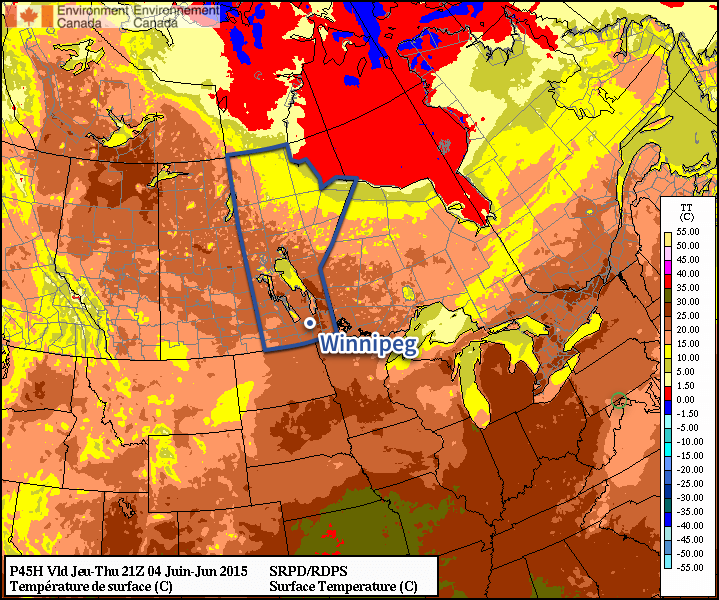
The RDPS is forecasting high temperatures near 25°C on Thursday across much of Southern Manitoba.
The second half of the work week looks great with both Thursday and Friday seeing highs in the mid 20’s and little in the way of significant wind. Thursday looks mainly sunny while a bit more cloud looks possible on Friday as a low pressure system moves north through Western Manitoba. No rain is expected.
Weekend Outlook
The weekend will bring back the chance for some rain with a system moving through on Saturday. Otherwise, the weather seems fairly nice with temperatures in the mid–20’s.
The first part of this week will see unsettled weather as a strong low pressure system passes to our south. This system will likely result in moderate rainfall and a risk of thunderstorms over southern Manitoba on Tuesday.
Monday
Today looks to be mainly cloudy ahead of an approaching low pressure system. There may be a few passing showers throughout the day, but no major precipitation is expected. High temperatures are expected to reach the low twenties with gusty south winds.
Tuesday
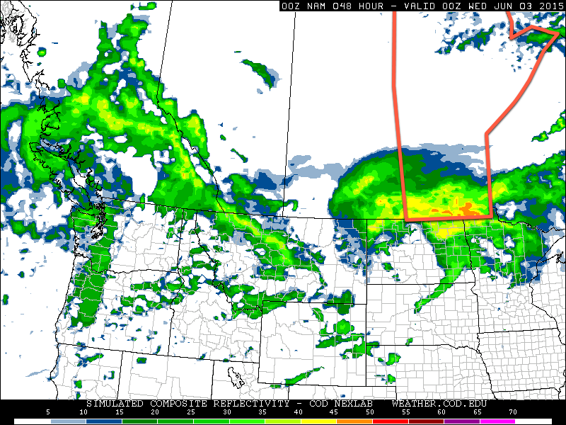
Tuesday looks quite unsettled as we sit north of a fairly strong low pressure system over the Dakotas. A warm front will likely be located over northern North Dakota, allowing for warm and potentially stormy weather just to our south. In southern Manitoba, we will remain stuck in a cool easterly flow north of the warm front. As a result of our position relative to the warm front we likely see moderate rainfall during the day with a chance of embedded thunderstorms.
The simulated RADAR reflectivity from the NAM forecast for Tuesday afternoon shows a large area of rainfall moving over Southern Manitoba.
Should the warm front move further north than expected, our risk of thunderstorms will be higher, but at this time that does not look probable. Total rainfall amounts in southern Manitoba could be in the 15-35 mm range, although it is difficult to predict this sort of system ahead of time. Higher rainfall amounts are certainly possible on a localized basis due to isolated thunderstorm activity.
Wednesday
Wednesday looks cool and cloudy as Tuesday’s system departs. We my see a few showers during the day, but in general not much precipitation is expected. The wind will be from the north at around 30 km/h.
Long Range
The long range forecast suggests we’ll see generally normal to above-normal weather through the middle of June. Numerous weak to moderate weather systems are expected to traverse the region over the next while, meaning our weather will continue to feature unsettled patches, before we return to more favourable conditions.
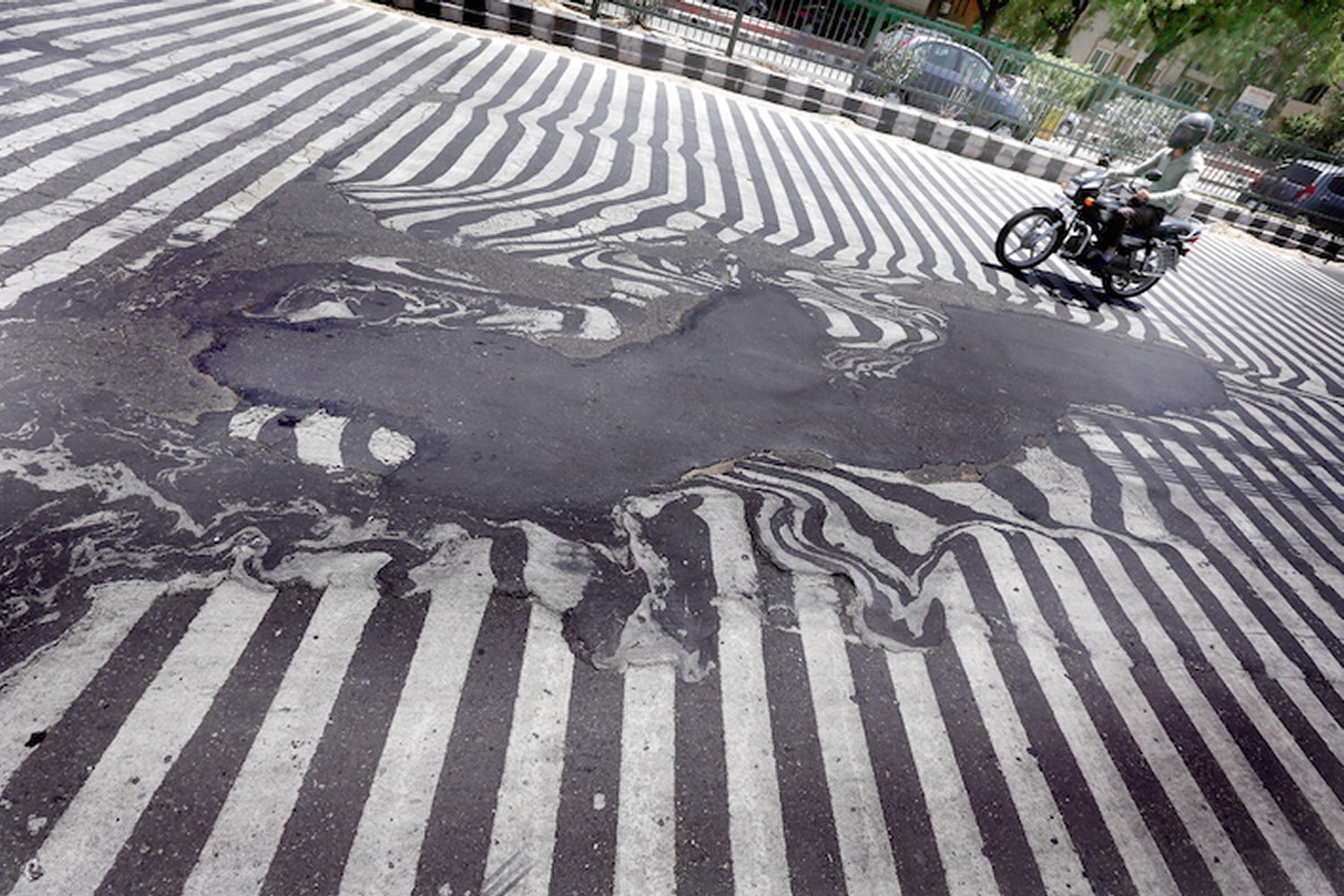
A weak ridge aloft has allowed extreme heat to build into the region while tropical dewpoints over 25°C remain in place. With these temperatures and dewpoints combined, several locations in Eastern India, like Bhubneshwar, have seen humidex values above 55°C – signifying heat stroke is probable with any time spent outside. Not only that, but overnight lows stayed well above 30°C for several days in some regions, providing no relief to the residents. Additionaly, dust storms have been taking place across the drought stricken areas in the north. In Rajasthan, a dust storm killed seven people two weeks ago. Heat waves can be crushing to developing countries, such as India, resulting in exponentially more deaths and damages compared to first world countries as residents have limited access to clean drinking water to hydrate themselves, never mind air conditioned houses.
Asphalt was literally melting away on New Delhi roads due to high temperatures this week. (Source: Rappler)
Over half of the deaths (1,334 deaths) associated with the heatwave came from the Andhra Pradesh province, while the most recent overall death tally reached 1,826 people. This, according to Jeff Masters of Weather Underground, is the fifth deadliest heat wave in world history since record keeping began and second deadliest to India (deadliest was 1998). Water shortages were the main problem leading to dehydration and heat stroke; to combat this, the country brought in water tankers and aid to over 4,000 towns in the hardest hit areas.
Help might be on the way however. The seasonal rains that India experiences, called monsoonal rains, are advancing northwestward towards the heat-stricken provinces. These will not only bring much needed moisture to the region, but also allow temperatures to drop well below what India has been experiencing past few weeks. The few weeks preceding the monsoonal season typically do bring heat waves and dry weather to India, but some years are harsher and last longer than others.
Just when it felt like Winnipeg was out of the woods and summer had arrived, conditions will make it feel like the clock has been turned back to the beginning of the month with temperatures 10°C below normal and a risk of frost returning for the weekend. The cooler weather is courtesy an Arctic airmass that is plunging southwards behind yesterday’s potent system that brought rain & thunderstorms to Saskatchewan & Manitoba.
Today will be a very cool day with brisk northerly winds at 30km/h with some gusts up to around 50km/h. Today’s high will top out at just 11–12°C through the Red River Valley with mixed-to-cloudy skies until the afternoon when things begin to clear up. Winds will ease tonight with temperatures plummeting towards the freezing mark. Winnipeg will just be ahead of the main ridge axis, making sub-freezing temperatures quite possible. Areas near the core of the city may escape frost, however anywhere closer to outskirts of the city will have a strong chance of seeing some frost. The low will vary depending where in the city the temperature is measured, but in general I expect it to be around 0°C with temperatures possible 1–2°C colder than than near the outskirts of the city. Rural areas will likely deal with overnight lows of –1 or –2°C.
The remainder of the weekend looks much calmer but still cool. Saturday and Sunday will see high temperatures returning back towards the mid-teens with mainly sunny skies. Some cloud will push through late Saturday through early Sunday which should help keep the overnight lows in the low-to-mid single digits.
A Glance At Next Week
The start of next week will bring a return to more seasonable high temperatures in the 20’s, however alongside the warmer weather comes the potential for more unsettled weather as multiple systems track through the Southern Prairies & Northern Plains.
As such, Southern Manitoba will likely be dealing with a decent chance for showers or rain through the first half of the week. Depending on how things develop, rainfall totals could be anywhere from a trace to over an inch, so we’ll be sure to track things as the weekend progresses. The weather looks to settle down for the second half of the week with daytime highs in the upper teens to lower 20’s.