Unsettled & Unpleasant May Long Weekend Ahead

Winnipeg, and many other regions in the Red River Valley, received the most significant rainfall so far this year yesterday as an area of moderate rain moved into the province from North Dakota and stalled out for much of the day. Rainfall totals in most places were near 20–30mm with slightly higher amounts in the southwestern Red River Valley:

Rainfall totals for the May 14, 2015
Location Rainfall Total (mm)
Letellier 41
Altona 37.6
Morris 34.2
Winkler 29.8
Steinbach 27.8
Winnipeg 24
Dugald 22
Elm Creek 12.6
Portage la Prairie 9.6

The Altona/Letellier areas seem to be the winners for total rainfall with almost 1.5” of rain in total. Unfortunately for farmers who are still working at getting seed into the ground, there won’t be much of a reprieve from wet weather before more rain is on the way as another major low pressure system is hot on the heels of the previous one and is set to bring a whole host of unsettled, pleasant and stormy weather for the May long weekend.

Pleasant Friday, then Downhill

Friday
18°C / 7°C
Partly Cloudy

Today will be a very pleasant day across the Red River Valley with mainly sunny skies and temperatures climbing into the high teens under partly cloudy skies. Winds will be fairly light out of the northwest. Friday night will see temperatures drop to around 7°C under clear skies. The nice weather won’t last too long, though, as a potent low pressure system moving into the Northern Plains of the United States tonight will result in cloud and some light rain spreading across Southern Manitoba early on Saturday.  The heaviest rainfall will hold off until much later in the day, however, as this system will end up being strongly driven by convection.

SPC Day 3 Convective Outlook valid Saturday May 16, 2015

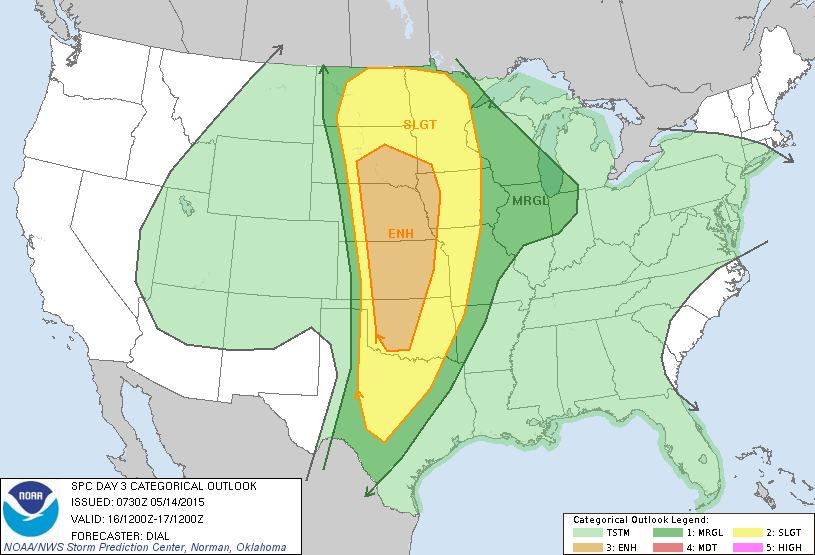
The SPC[1] in the US currently has a slight risk of severe thunderstorms in their outlook for Saturday scrunched right up the Canadian border. Further north in our area, it looks like an initial shot of some showers associated with elevated convection will lift through the region early in the day. Temperatures will warm towards the 20°C mark with an increasing risk of showers or thunderstorms.

Saturday
20°C / 9°C
Cloudy; scattered showers with the risk of a thunderstorm

Later in the afternoon, best indications at this point are that an area of thunderstorms will initiate in North Dakota and push northeastwards through the Red River Valley. It looks like precipitation will most likely be showers or weak thunderstorms, however the outside chance exists that an isolated severe thunderstorm may be seen. A thunderstorm outlook later will be issued later today covering all of Southern Manitoba.

A few showers will be likely through the overnight hours as the temperature drops to 9°C or so.

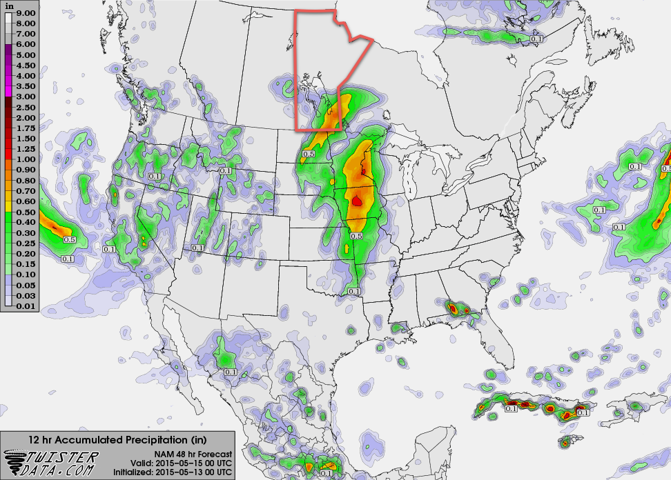
Sunday will be the most significant precipitation day with rainfall intensifying through the morning into the afternoon. There’s some uncertainty as to where the western cut-off will be for the rain, but general consensus at this point is that the entirety of the Red River Valley will see rain on Sunday.[2] Total accumulations are hard to nail down at this point, but look to be in the 25–50mm range.

Sunday
10°C / -3°C
Rain

Things take an unwelcome turn on Sunday evening as colder air works its way into Southern Manitoba on the back-side of the system. Rain may become mixed with or switch over to snow as it begins tapering off. No significant snow accumulations are expected. Temperatures will drop off to around –3°C on Sunday night with winds gradually tapering off.

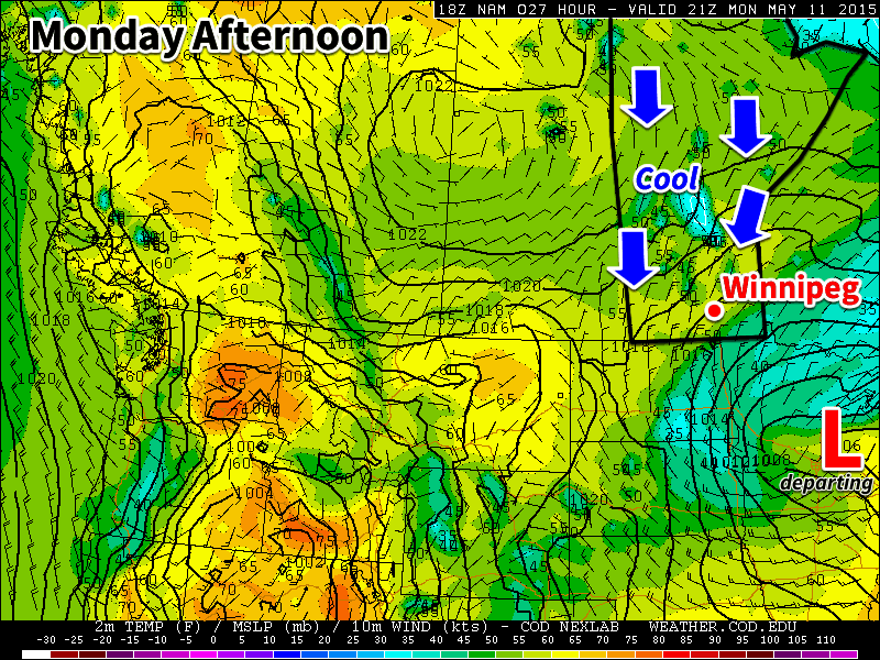
Holiday Monday A Cool Improvement

Looking ahead to the start of next week, it looks like Monday will mark the transition out of this active pattern we’ve been in. Sunny skies and exceptionally cool weather look to be on tap with highs struggling to get to even 10°C[3]. Conditions will improve over the subsequent days with drier weather and temperatures returning to the seasonal mark.


  1. Storm Prediction Center  ↩
  2. The GDPS is a bit of an outlier, keeping rain wrapped tightly to the surface low pressure system in Minnesota and keeping the bulk of Sunday’s rain southeast of Winnipeg.  ↩
  3. Average highs for May 18th are around 21°C.  ↩

More Wet Weather Through Second Half of the Week

More wet weather is on the way to Winnipeg & the Red River Valley as a slow-moving upper-level disturbance bears down on Southern Manitoba. The bulk of the rainfall associated with this next system will be quite a bit more concentrated than last week’s Colorado Low with much of the precipitation being produced by a single, relatively narrow band of moderate rainfall sliding across the region.

Winnipeg will see a high of around 12°C today with cloudy skies through the day. Shower activity will push northwards through the Red River Valley over the morning hours bringing a decent chance of some rain to Winnipeg by mid-to-late afternoon. Winds will be breezy out of the southeast at around 30km/h with a bit of gustiness on top.

Clouds will stick around tonight as the temperature drops to around 7°C with a continued slight chance of showers through much of the overnight period. The next disturbance will move into Southern Manitoba late overnight, spreading rain from SW to NE starting near the Pilot Mound/SW RRV region and lifting towards Winnipeg.

NAM 12hr. QPF valid 00Z Friday May 15, 2015
The NAM is forecasting around 10-15mm of rain for much of the Red River Valley on Thursday, with some areas seeing as much as 20-25mm.

Thursday will start off as a fairly rainy morning, then see rain taper off from west to east through the afternoon. Skies will remain cloudy through the day with winds out of the east. Expect a high near 13°C. The low on Thursday night will be around 7°C under mainly cloudy skies.

When all is said and done, it’s possible we’ll see somewhere from 10–20mm of fresh rain, however this entire system may end up shifting slightly further west which would leave the Red River Valley fairly dry until remnant showers pass through on Thursday night. We’ll be sure to keep tabs on things as they develop through the day and update with the most likely outcome later tonight.

Friday will bring a break from the gloomy weather as things clear out through the morning, leaving us with sunshine and a high near 19°C and light winds.

Long Range

This weekend will bring another disturbance through the region that has the potential to produce a significant amount of rainfall – 25–50mm – however there’s still a lot of uncertainty associated with the system and many divergent model solutions at the moment. It will likely be a generally unsettled week at best, and potentially a downright rainy one at worst. Some forecasts are showing some fairly favourable convective parameters on Saturday that would hint towards the first significant thunderstorm day of the year, but a decent capping inversion looks to keep things at bay as long as the current forecasts hold out.

Seasonal Weather Returns

We’ll see seasonal weather return this week after a chilly weekend. Temperatures will climb into the mid to upper teens by midweek.

Monday will remain cool as we stay in a northerly flow behind a departing low pressure system

Monday

Today will remain below-seasonal, but temperatures will warm somewhat over the weekend’s values. High temperatures should climb into the mid teens in the Winnipeg and Brandon areas. However, areas closer to the US border will remain under thicker cloud cover and will struggle to reach double-digits. The wind will be brisk at 30 km/h from the north.

Tuesday

Tuesday will be a nice day, as temperatures climb into the mid/upper teens under mainly sunny skies. Winds will be light as high pressure settles in over the region.

Wednesday

Wednesday will be similar to Tuesday, but there will likely be a bit more cloud cover as a system passes to our south. Temperatures will be in the upper teens under a mix of sun and cloud and light winds.

Long Range

It appears that temperatures will continue to warm through the end of the week. However, long range models hint at another weather system passing to our south next weekend, which may once again draw down some cooler air from the north. In general, models suggest that our weather will hover near normal values for the next couple weeks.

Multi-Day Severe Weather Setup Leads to Tornadoes, Flash Flooding in Oklahoma

Early May is typically when the severe weather season really ramps up in the US Plains and this week has certainly lived up to that. The region has seen severe weather every day since Wednesday and is expected to see more today. A western troughing pattern has been dominant the past few days, allowing a strong southerly flow to take place in the lower levels of the atmosphere – advecting in plenty of moisture from the Gulf of Mexico located nearby. High levels of instability, coupled with enough shear to support supercells was in place.

[map autofit=”1″ disable_scrollwheel=”1″] [pin tooltip=”Bridge Creek”]Bridge Creek, ok[/pin] [pin]Norman[/pin] [/map]

The worst day of the outbreak tornado-wise occurred on Wednesday where 48 tornadoes touched down from Nebraska, all the way down to Texas. A particularly dangerous situation unfolded in Oklahoma as a supercell with a history of producing tornadoes moved northeast along I-44 and through the large city of Norman where it dropped a tornado, later rated EF-1. The same supercell also produced an EF-2 tornado near Bridge Creek, shortly before it dropped the Norman tornado. Tornadoes were not the only threat on Wednesday; significant rains fell across Oklahoma, including Oklahoma City, which saw trailing supercells hit the city and as a result severe flash flooding. One person died from the storms, while a few dozen were injured. Ditches became raging creeks that spilled their banks onto highways and residential areas. It’s not uncommon to see supercells drop 100mm of rain or more in an hour. Radar indicated that some areas just southwest of Oklahoma City saw over 250mm on Wednesday. Numerous stations in the area broke their daily rainfall records from this event. A state of emergency was issued in 12 counties as a result of the storms.

Chickasha Supercell
The tornadic supercell that hit Norman in its early stages, showing an obvious hook. (Source: Radarscope)
Oklahoma Flooding Rains
Storm total accumulation for Wednesday through 9pm shows areas of over 250mm (pink areas). (Source: Radarscope)

More severe weather is expected today as the trough shifts slightly eastwards. There’s a chance that today could be the second significant tornado day in less than a week in the Plains – Kansas, southeast Colorado and northern Oklahoma regions are under the gun. However, there are still a few uncertainties due to the models showing some mid-day convection possibly limiting the heating. The Storm Prediction Center had issued a moderate risk for the region as of Friday night. Regardless of what happens in the first half of the day, there will be severe storms; residents in the region will have to keep an eye on the sky for large hail, severe winds, torrential rains and even tornadoes!