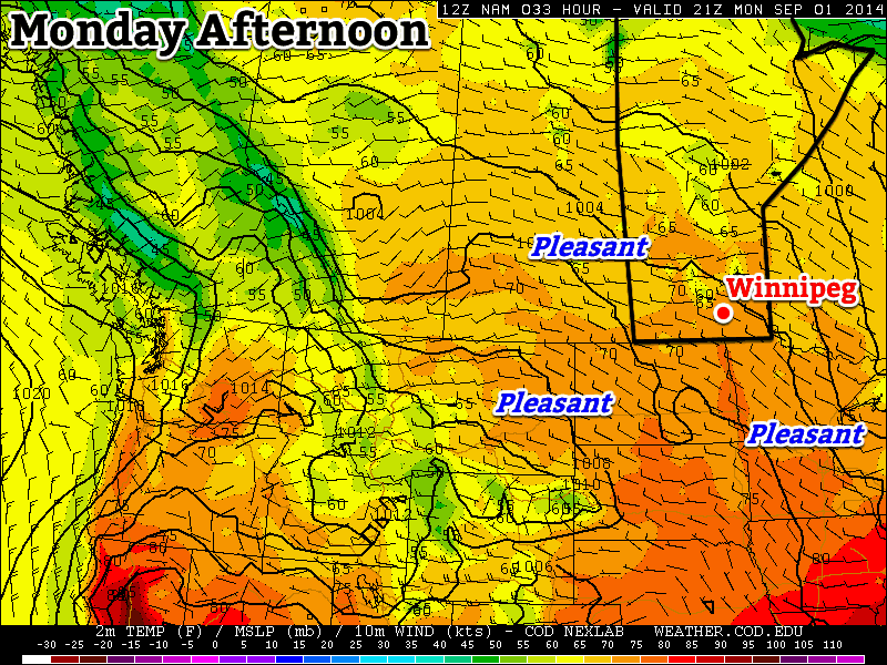
This week will start off with pleasant conditions, as we experience a nice end to the long weekend.
Labour Day will be pleasant in southern Manitoba
Monday
Monday
23°C / 8°C
Mix of sun and cloud with a chance of showers or thunderstorms
Today will be a pleasant day in southern Manitoba. Temperatures will be in the low to mid twenties with a light westerly wind and partly sunny skies. There will be a slight chance of showers or thunderstorms, but any rain should be isolated and short-lived. Overall, it will be a good end to the last long weekend of summer.
Tuesday
Tuesday
24°C / 10°C
Mix of sun and cloud with a chance of showers or thunderstorms
Tuesday will be another nice day in southern Manitoba. Skies will be a mixture of sun and cloud, with temperatures in the mid twenties. There will once again be a slight chance of showers or thunderstorms, but they’ll again be isolated.
Wednesday
Wednesday
24°C / 13°C
Mix of sun and cloud
Wednesday will once again feature seasonably warm conditions in southern Manitoba. High temperatures will be in the low to mid twenties with light winds.
Long Range
The long range forecast is a bit uncertain at this time. It looks like we’ll generally see near seasonal conditions in the short to medium term, which means temperatures in the lowish twenties. There will however be some days warmer, and some cooler, than seasonal values.
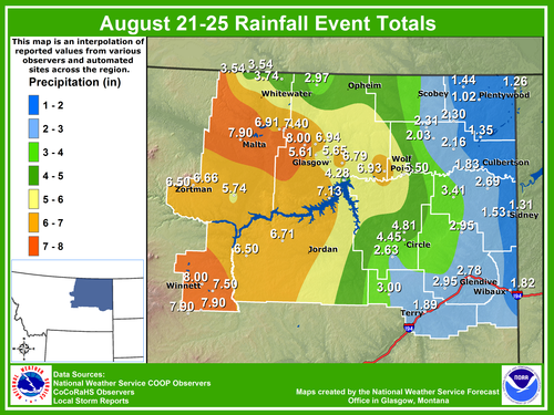
The same strong low pressure system that brought 20–40mm to the Red River Valley last weekend brought significant rainfall to parts of central and eastern Montana. These extreme rainfall events in August are uncommon for Montana as strong systems usually stay well north with the polar jet stream and wildfires are typically the concern around this time of the year.
Storm total rainfall for parts of central and eastern Montana (in inches). (Source: NWS Glasgow)
The deep low pressure system brought heavy rain (with a few breaks) to the region between August 21st and the 24th. Combined with abnormally high Precipitable Water values (PWAT) in the region, this made for high rainfall totals throughout the region. Storm total reports between 175mm and 200mm were not uncommon. Glasgow, MT saw around 145mm fall through the event (Aug. 21–24) which is four and a half times their monthly average rainfall for the whole month of August. In comparison to last year, they had less than a quarter of their monthly average rainfall by this time.
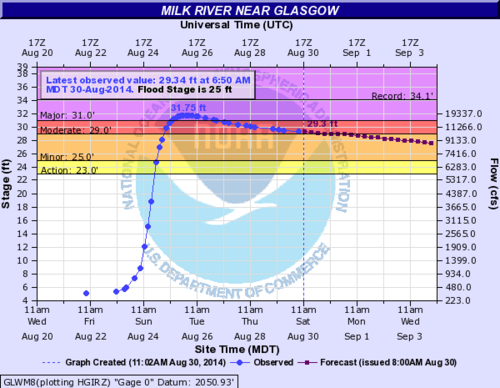
Milk River near Glasgow reached major flood stage Monday and Tuesday. (Source: NWS Glasgow)
Many rivers in the regions quickly swelled up and spilled their banks including the Milk River which entered major flood stage near Glasgow on Monday. Mudslides also became a concern in the more mountainous regions. It appears that most of the damage due to the flooding occurred to roads and culverts, however some homes were damaged as well. Thankfully, there have been no reports of injuries. Crews are slowly working to rebuild the washed out roads.
More rain is impacting the region today, but nothing close to the magnitude of what was seen last weekend.
Seasonal weather will be in place over southern Manitoba as the last long weekend of the summer arrives. Conditions will be fairly dry except for a disturbance rolling through on Saturday night.
Friday
22°C / 8°C
Chance of morning showers, then clearing
Saturday
23°C / 14°C
Mainly sunny; showers or thunderstorms likely overnight
Sunday
23°C / 10°C
Morning showers or thunderstorms then clearing
All in all it’s going to be a lovely weekend with most of the chances for precipitation outside of “plan-ruining” hours. Today we’ll see a chance for some morning showers – or perhaps even an isolated thunderstorm – as a cold front passes through the Red River Valley. Winds will shift to the north behind the front and temperatures will climb to around 22°C under increasingly sunny skies for the afternoon.
Tonight will be clear with a low of around 8°C.
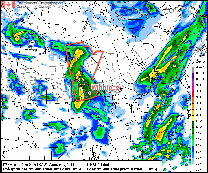
Saturday will be a very pleasant day with mainly sunny skies and a high near 23°C. Winds will shift to southerly through the day, but remain relatively light at 20–30km/h. Some cloud will begin streaming into the Red River Valley ahead of an approaching low pressure system that will move through on Saturday night.
Storm-total precipitation amounts forecast by the GDPS for Saturday night’s storm.
This system will be compact and intense with strong dynamics associated with it. Showers and thunderstorms will spread into the Red River Valley overnight on Saturday – likely not until late overnight. It’s unclear if much of a severe threat exists with these storms, although it does look like they could be fairly strong. Rainfall amounts will be dependent on the timing and intensity of convective activity, but in general it looks like 10–20mm of rain is likely, with isolated amounts approaching 50mm possible in worst-case scenarios.
The activity will continue into Sunday morning and clear out by mid-day. The rest of Sunday will be quite nice with clearing skies and temperatures climbing to around 22°C. Sunday night will be mainly clear with temperatures dipping near the 10°C mark.
A Beautiful Holiday Monday
For the upcoming holiday Monday, it looks like another pleasant, seasonal day with highs near 21 or 22°C and mainly sunny skies. The pattern looks to hold for much of the remainder of the week, where conditions look dry and the possibility of some warmer weather returns near week’s end.
After an early blast of fall-like weather earlier this week, Winnipeggers will be pleased to hear that summer will quickly return to Southern Manitoba.
Wednesday
24°C / 13°C
Warming up with some afternoon cloud
Thursday
27°C / 15°C
Mainly sunny. Off-chance of a late-day shower
Friday
23°C / 9°C
Morning cloud with gradual clearing
There’s little to say about the weather heading our way the next few days. Today will be a pleasant day with highs near 24°C with some afternoon cloud and winds gradually increasing out of the south to 20–30km/h. Temperatures will dip to around 13°C tonight with partly cloudy skies.
Tomorrow will be a warmer day across the region with highs near 26 or 27°C. A cold front will begin working its way through western Manitoba through the day and push into the Red River Valley overnight. Despite ample surface moisture, stronger mid-level dynamics remain further north in the Interlake, so it’s likely that the front will be relatively unimpressive through the Red River Valley, but there will still be an off-chance of some isolated strong thunderstorms. In general, showers will be much more likely along the front as it pushes eastwards. Temperatures will drop into the mid-teens Thursday night in Winnipeg with a small chance of showers.
Friday will be a cooler day thanks to the cold front that will push through on Thursday. Highs will be limited to the low 20’s and the day will start off with cloud that will then gradually clear throughout the day. The low on Friday night will drop back into the high single-digits.