Seasonal Weather Continues

The weather will remain unexciting as a ridge of high pressure exiting the Prairies gives way to more cloud & flurry activity. Snowfall may become slightly more organized by the end of the week, but no significant events are in the forecast.

Wednesday
-10°C / -18°C
Mainly sunny
Thursday
-9°C / ⇒ -9°C
Increasing cloud; light snow overnight
Friday
-5°C / -9°C
Cloudy with flurries

Today will bring sunny skies and a high near -10°C. Winds will be calm.

Skies will remain clear tonight as temperatures drop to around -16°C. Winds will remain relatively light.

Thursday will start off fairly sunny and become increasingly cloudy through the day. While there’s an ever-so-slight chance of a light flurry through the daytime, the bulk of the activity should hold off until the overnight hours. Temperatures will climb to around -9°C with relatively light winds.

Temperatures will remain fairly steady near -9°C on Thursday night with some flurries looking fairly likely.

Friday will be the warmest day of the week with temperatures climbing to around -5°C. It will also be cloudy with a very good chance of light snow thanks to a weak upper-level trough sliding across the province. Temperatures will dip to around -8°C on Friday night with cloudy skies and a chance of continued flurry activity.

Despite all the snow in the forecast, little of it will accumulate. Friday stands the best chance at seeing something, but even then it would only be a cm or so at most.

Not Much Between Now And Christmas

The weather, in general, is looking quite unremarkable between now and Christmas.

The NAEFS 8-14 day temperature outlook is calling for near-normal conditions over Southern Manitoba.

The temperature outlook continues to be seasonal with no dramatic swings over the next while. Snow-wise, no significant systems look to impact southern Manitoba between here and Christmas. Through the first half of next week it looks like a weak inverted trough may bring a couple of days of light snow or flurry activity to the province, but once again it looks like it would produce little in the way of accumulations.

So in lieu of any interesting weather, get out there and enjoy what is shaping up, for December, to be an exceedingly bearable winter!

Warm Spell Comes to an End

The little warm spell we’ve been in over the past several days has come to an end. Cooler temperatures are in store for this week, but conditions will remain above-normal.

Cooler weather is expected in southern Manitoba on Monday

Monday

Monday
-8°C / -13°C
Mainly cloudy with a chance of flurries

Today will see temperatures fall from the very mild conditions experienced on the week. High temperatures will be in the upper minus single digits, with a gusty north wind. There is a chance of flurries during the day, particularly in the morning. Unfortunately, even this change in the weather isn’t expected to reveal the sun, as we continue to languish under mainly cloudy skies.

Tuesday

Tuesday
-11°C / -15°C
Mainly sunny

Tuesday will be slightly colder than Monday, but not by much. High temperatures will be around the -10°C mark, with a light north-west wind. The sun should finally come out, making for a mainly sunny day.

Wednesday

Wednesday
-10°C / -18°C
Mix of sun and cloud

Wednesday will see temperatures that are very similar to Tuesday. Highs will once again be near the -10°C mark. Winds will be light, making for a fairly pleasant day. Cloud cover will be variable, with generally a mix of sun and cloud through the day.

Long Range

The long range forecast suggests we’ll see a gradual warming trend as we move towards the weekend. Temperatures will likely move towards the mid minus single digits, which is still above-normal for this time of year. No major arctic blasts are currently in the forecast, allowing our mild December to continue!

Elsewhere in Weather News: December 13th, 2014

West Coast Hit With Strong Winds, Heavy Rains

The West Coast of North America has been subject to several systems after coming onshore in the past couple weeks, bringing with them heavy rains and strong winds which has led to flooding. Once again, the culprit for the moisture-laden systems in this region has been the atmospheric river. This atmospheric river is a term used for streams of moisture typically originating in the tropics, which head Poleward. Eventually the water precipitates out – it is often enhanced along the west coast due to orographic precipitation, leading to flooding.

Higher PW values streaming from the tropics to the Californian coast are associated with the atmospheric river. (Source: CIMMS)

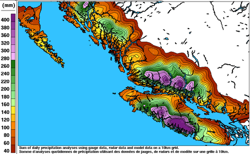
Earlier this week, the BC coast was hardest hit where over 400mm fell on parts of Vancouver Island in 6 days. Flood watches were issued as towns on the Island watched waters rise. The towns of Courtenay and Port Alberni were soaked with over 150mm by Wednesday – some residents were forced to evacuate their homes due to the rising waters. Strong winds were also a problem; gusts over 100km/h were recorded across the coast, even in large cities such as Portland, OR. These winds knocked out power to roughly 75,000 residents in BC alone. In addition to the wind and rain, landslides also became of concern in Southern California. Saturated grounds led to a large slide in Camarillo Springs, CA, which affected over a dozen houses.

Estimated rainfall along the BC coast from December 4 to the 10th. (Source: Environment Canada)
Estimated rainfall along the BC coast from December 4 to 10. (Source: Environment Canada)

The system even brought a weak EF-0 tornado which was spun-up in one of the stronger rain bands that came onshore. The tornado passed through a small area in southern Los Angeles yesterday morning and stripped roofs of their tiles – no one was injured thankfully. Reports of 60-100mm were common along the Californian coast, but localized amounts of 200mm or higher did occur. The highest precipitation report as of Friday came from an area in the northern Sierra Nevada Mountains where 450mm of precipitation fell; the amounts here were enhanced by orography.

Unfortunately models are showing another system impacting most of the West Coast early next week, not leaving much time for things to dry out.

Mild But Dreary Weather Continues

The weather pattern that has brought temperatures well above seasonal to Winnipeg[1] – despite the persistence of low cloud supplied by the outflow winds of a high pressure system to our southeast – will continue to pump warm Pacific air eastwards into the region for another couple days. By the end of the weekend, however, a cold front is set to push through bringing more seasonal temperatures back to the Prairies.

Friday
1°C / -2°C
Mainly cloudy
Saturay
3°C / -3°C
Mixed skies
Sunday
-1°C / -13°C
Mainly cloudy; slight chance of flurries

Winnipeg will see cloudy weather today as low cloud entrenched in the Red River Valley refuses to exit as southerly outflow winds continue to reinforce the low-level moisture trapped underneath the substantially warmer air just off the surface[2] that has spread over southern Manitoba.

The cloud will be accompanied by breezy southerly winds to 30-40km/h. The temperature will only climb to around 0 or +1°C today. Some clearing is possible later in the day as drier air begins pushing eastwards into the Dakotas and may work its way northwards in the flow. It’s far from certain, but we could see some breaks in the cloudy skies later today into the evening. Temperatures will drop to around -2°C tonight.

This Winnipeg forecast sounding – valid at 10AM CST Friday, December 12, 2014 – shows a thin layer of saturated air right at the surface which will continue to produce low-level cloud.
This Winnipeg forecast sounding – valid at 10AM CST Friday, December 12, 2014 – shows a thin layer of saturated air right at the surface which will continue to produce low-level cloud.

Saturday looks to bring mixed skies with a lot of uncertainty on exactly what we’ll see. Weather models want to clear things out fairly well and give us sunny skies with a high near 6°C. Unfortunately, I’m not entirely convinced that’s what will happen. The Red River Valley will sit on the cusp of where the return flow from the high pressure system meets drier air pushing in from the southwest. However, a low pressure system approaching from the west will likely back the winds slightly, tapping into the low-level moisture in the outflow winds from the high. Additionally, large-scale lift ahead of the low could also work to develop more low cloud ahead of the approaching cloud. So while the day may end up sunny, it seems a bit more likely we’ll see mixed skies or increasing cloud through the day. Due to that, I think the high will be closer to 3 or 4°C with temperatures dropping to around -3°C overnight under mainly cloudy skies.

Sunday will be a mainly cloudy day as a low pressure system passes to our south. Northwesterly winds will bring more seasonal Arctic air into the region through the day, limiting our daytime highs to -1°C with just a slight chance for some light flurries.

Through much of next week seasonal to slightly above seasonal temperatures are expect with no significant precipitation events in the forecast.


  1. Our daytime highs near -1°C are about 8°C above seasonal for this time of year.  ↩
  2. As shown in the figure mid-way through this post, while surface temperatures will struggle to climb just above 0°C, temperatures just 1.5km off the ground are nearly 17°C.  ↩