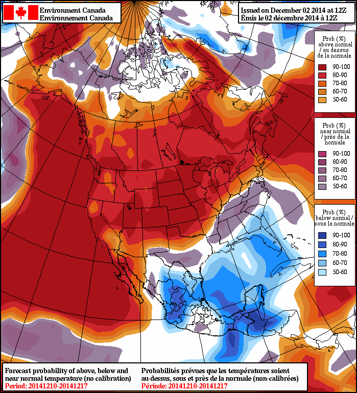
Hot Weather Returns; Another Thunderstorm Risk

An upper ridge building into the eastern Prairies will bring the heat back, sending the temperatures back towards the 30°C mark.

Conditions will be beautiful – and very welcome to those sick of all the rain this summer – with plenty of sunshine through the second half of the week. A low pressure system will drag a trough across Southern Manitoba late Thursday into Friday morning, which will likely spark off another round of thunderstorm activity through the region.

Monday: Start the Warm-Up

Wednesday
24°C / 13°C
Mainly sunny

Today will be a beautiful day with light winds, mainly clear skies and a high near 24 or 25°C. The “significant” weather event of the day will be the passage of a ridge of high pressure which will be marked by a gradual transition of the winds from northerly to southerly, setting up the return flow of heat for the remainder of the week.

Thursday: Hot with Severe Thunderstorm Risk

Thursday
28°C / 19°C
Increasing cloud & breezy

UPDATE: Updated thunderstorm discussion is available in the comments, right here.

Things become more interesting on Thursday as a low pressure system tracking along the NWT/Nunavut border drags a secondary frontal wave across the southern Prairies. Temperatures will soar into the high 20’s across southern Manitoba on Thursday with a southerly wind at around 30km/h. Humidity will also build ahead of the approaching system with dewpoints rising into the mid-to-high teens by the end of the day.

Clouds will likely begin building into the Red River Valley through the afternoon, but no precipitation is expected until the overnight hours.

The GDPS precipitation forecast for Thursday night shows nocturnal thunderstorms across Southern Manitoba.

At this point, it’s too early to go into specifics, but even already it looks like there’s a slight chance of severe thunderstorms over western Manitoba on Thursday evening with all modes of severe weather possible.[1] The threat will continue eastwards overnight as the storms become elevated and continue on through the night. The southward extent of the storm activity is unclear now, but it seems that for Winnipeg and the Red River Valley, there’s a decent chance we’ll see thunderstorms overnight with greater likelihood northwards through the Interlake. These storms will also have the risk to be severe with large hail and strong winds.

Pleasant Friday

Friday
26°C / 14°C
Mainly sunny

Friday will find Winnipeg on the back-side of the system moving across the Prairies and will see quite pleasant conditions with a ridge of high pressure building in from the west. Temperatures will be pleasantly warm with highs near the mid-to-upper 20’s and light winds. Temperatures will drop into the mid-teens overnight.

Long-Range

Bad news everyone. Brace for the return of below normal. A prominent long-wave ridge is forecast to build up over western North America with a resultant long-wave trough developing over Hudson Bay into the Great Lakes.

The CPC 6-10 day temperature outlook shows below normal temperatures through Southern Manitoba.

This will set up a persistent northwesterly flow which will likely produce slightly below-normal temperatures.[2] The heat and main storm track will shunt southwards into the Northern & Central Plains, leaving us with just the odd system sliding southeastwards in the northwesterly flow.


  1. All modes being large hail, damaging wind gusts, torrential rain causing localized flash flooding and the risk of a tornado.  ↩
  2. Normal high temperatures in Winnipeg for early-to-mid July sit near 26°C.  ↩

Unsettled Start to the Week, then Heat Returns

This week will start out on a cooler and more unsettled note, but then conditions will begin to change. Hot weather looks set to return before the weekend.

Showers and thundershowers will develop in Manitoba on Monday due to destabilization from daytime heating

Monday

Monday
24°C / 10°C
Showers and Thundershowers

Today will be quite unsettled, with a good chance of showers and thundershowers. Skies will start out mainly sunny in the morning, but daytime heating will quickly cause the atmosphere to become unstable, allowing widespread convective precipitation to develop. For the most part the precipitation will be in the form of showers, but there will likely be some thunder in lightning in some of the cells as well. Some small hail could even occur in some of the stronger cells. This activity will die off in the evening, with little rain expected overnight. High temperatures today will be in the low to mid twenties with a breezy north-west wind.

Tuesday

Tuesday
23°C / 11°C
Mix of Sun and Cloud with Chance of Showers

We may see some more shower activity on Tuesday, but it will be less widespread than Monday. Most areas will see a mix of sun and cloud through the day, with temperatures in the low, or maybe mid, twenties. The wind will once again be breezy and from the north-west.

Wednesday

Wednesday
26°C / 14°C
Mainly Sunny

Wednesday looks like quite a nice day in southern Manitoba. The heat will begin to return, with high temperature climbing up into the mid and upper twenties. Skies should remain mostly sunny, though the odd pop-up shower can’t be ruled out. The wind should be fairly light, with the direction being somewhat variable as we’ll be under the eastern edge of a high pressure ridge.

Long Range

The current long-range forecast looks good for those that like the heat! Models suggest that hot weather will continue from late this week into next weekend. We’ll likely see humidity gradually build late in the week as well. We may even see another risk of strong storms at some point once that humidity starts to return, but it’s too early to say if and when that might occur.

The Heat is On

The hottest weather of the year will give way to a return to unsettled conditions with multiple low pressure systems tracking through the province over the next week.

Temperatures will soar over the next few days as very warm air moves into the region alongside increasing dew points, resulting in some blisteringly hot weather. The decidedly summer-like weather will be short-lived, though, as a system moving through on Saturday puts southern Manitoba back into an unsettled pattern with multiple follow-up low pressure systems expected over the coming week.

Dew point values are forecast to climb over 20°C today (shown in orange colours).
Dew point values are forecast to climb over 20°C today (shown in orange colors).

Start the Warm-Up

Friday
28°C / 19°C
Hot and increasingly muggy. Slight chance of a shower or thunderstorm.

Today will mark the start of a significant warm-up. Southerly winds at 20-30km/h will help our dew point rise through the day to around 20°C, making it feel fairly muggy outside by the end of the day. The temperature will climb to around 28°C, which will feel more like 35 or 36 with the humidity factored in.

There will be a very slight chance of a shower midday or early in the afternoon. The evening looks quite nice at this point, and then Winnipeg & the Red River Valley will see a chance of a thunderstorm overnight. The low will be around 19 or 20°C.

AWM thunderstorm outlook for July 4th into the 5th, 2014. Full discussion is available in the comments.
AWM thunderstorm outlook for July 4th into the 5th, 2014.

UPDATE: A discussion on today/tonight’s thunderstorm potential is available below in the comments.

Saturday: Sweltering Heat and Severe Storms

Saturday
32°C / 18°C
Hot and muggy. Slight risk of severe thunderstorms.

Make sure your A/C is in tip-top shape, because Saturday is going to be a scorcher. Even warmer air will push into the region on Friday night, making high temperatures on Saturday soar all the way into the low 30’s. Here in Winnipeg, the daytime high should sit somewhere close to 32°C. When combined with the humidity, it will feel more like 40 or 41 outside, easily making it the warmest day of the year so far. Winds will be fairly light out of the south shifting to westerly at around 20km/h.

AWM thunderstorm outlook for July 5th into the 6th, 2014. Full discussion is available in the comments.
AWM thunderstorm outlook for July 5th into the 6th, 2014.

UPDATE: A discussion on today/tonight’s thunderstorm potential is available below in the comments.

All that heat and humidity does mean there will be a risk for severe thunderstorms. At this point it there’s still a fair amount of uncertainty as to whether or not storms will develop or not, so we’re going to wait until tomorrow to do a detailed thunderstorm outlook. In general, most storm parameters look quite favourable, but a strong capping inversion will be in place in the low-levels. Two potential triggers will need to be watched:

  1. A weak cold front slumping southwards through the day – I don’t think this is very likely to trigger much.
  2. A shortwave and associated jet maximum moving along the international border overnight.

If any thunderstorms develop, they will likely be severe. The main threats will be torrential rain[1], large hail and strong winds. Right now it seems most likely that thunderstorms will hold off until overnight, but we’ll take a closer look later today and add a thunderstorm outlook to this post.

Sunday Showers?

Sunday
26°C / 15°C
Chance of showers or thunderstorms.

Sunday will be a generally unsettled day with a risk of showers or thunderstorms as a cold front pushes across the province. Winds will pick up out of the west to around 40-50km/h as we head to a high of around 26°C. Severe weather is not expected right now, but the showers or thunderstorms moving through the region could be heavy/strong.

Winds will stay strong through the night as temperatures dip to the mid-teens.

Unsettled Week Ahead

There will be plenty of chances for showers or thunderstorms in the coming week. Right now it looks like the best chances are Monday, Tuesday night, then Friday. Highs will likely be in the mid-20’s with lows in the mid-teens and the humidity will remain at more comfortable levels.


  1. Yes, especially because we need more rain.  ↩

A Chance to Dry Out

A ridge of high pressure building into the province will offer several days of dry weather.

A break from the wet weather is finally here thanks to a ridge of high pressure that is building into the province. In a pleasant change of events, that will allow this forecast to be a whole bunch shorter than many of late.

Wednesday
22°C / 10°C
A few clouds

Thursday
25°C / 12°C
Mainly sunny

Friday
26°C / 18°C
Cloudy periods

The dry weather can’t come soon enough as the flooding situation continues to worsen over the southwestern corner of the province. Fortunately, conditions will be near-perfect over the next several days.

Today will bring a few clouds and a high in the low 20’s as the ridge begins pushing into Manitoba. Winds will be quite light today out of the northwest at around 15km/h. The temperature will drop to around 10°C under clear skies tonight.

Thursday will be a much more summer-like day with sunny skies and a high near 25°C. Winds will be light out of the southwest at only around 15km/h. Clear skies again tomorrow night as we head towards a low of 12°C.

Summer continues its return on Friday as temperatures climb a degree or two higher than Thursday. We’ll see a few cloudy periods as a warm front pushes towards the province. The temperature will fall to around 17 or 18°C on Friday night with a few clouds.

Blistering Weekend Ahead

Looking ahead to the weekend, there is only one word to describe it: hot. A very hot and humid air mass will build into southeastern Saskatchewan on Friday and then spread eastwards into Manitoba on Saturday. High temperatures will be in the lower 30’s on Saturday while dew point values climb into the 21-24°C range. The heat and humidity will combine to likely produce humidex values over 40 on Saturday. Needless to say, that is swelteringly hot and will firmly remind people that we are, in fact, in the middle of summer.

Sunday will continue to be hot until a cold front sweeps through in the afternoon. Temperatures will climb into the upper 20’s or just break 30°C which will feel more like the upper 30’s thanks to the humid air still present in the region. Slightly cooler and drier air will move in for Sunday night and next week as the winds shift westerly behind the cold front.

Any storm potential for the weekend is still unclear. To some degree severe storms are always possible when such hot and humid air pushes into our region, but at this point there simply isn’t a clear indicator as to whether anything will develop. We’ll have more on it later in the week.

Enjoy some dry weather and, finally, a real taste of summer!