Unsettled End to the Week

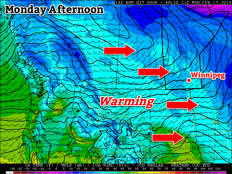
Temperatures will slowly return to slightly below-seasonal values through the remainder of the week as unsettled weather pushes into the Red River Valley. While the main weather focus will remain further east as a significant low pressure system lifts through Central Ontario, the storm will have a broad reach spanning all the way from the Maritimes to Southern Manitoba.

This forecast precipitation panel from the GDPS shows the significant extent of this week's develping storm.
This forecast precipitation panel from the GDPS shows the significant extent of this week’s develping storm.

One More Mild Day

Wednesday
-4°C / -9°C
Increasing cloud; mild. Snow overnight.

Today will bring another fairly nice day a westerly flow aloft continues spreading warm air into Southern Manitoba. Temperatures should climb up to around -4°C with relatively light southeasterly winds. Cloud coverage will increase through the day as a trough of low pressure works it’s way towards the Red River Valley, bringing with it another batch of snow and the beginning of of our transition back towards seasonal to slightly below-seasonal temperatures.

As the cloud pushes in, so too will the snow. Initially, the snow will spread into the Parkland region of the province – through Dauphin and down towards Minnedosa – before pushing eastwards into the Interlake. As the system tracks east, it will do it’s best to develop some light snow over the Red River Valley as a low-level jet ramps up and lifts over the warm front stationed in North Dakota. It’s still too early to say exactly how this is going to shape out: the location and intensity of the precipitation will have a lot to do with the exact track & timing of the system. If things line up right, we may see a band of moderate snow track across the RRV fairly early in the evening, but just as likely is that the LLJ doesn’t really get precipitation going until it’s further east into Minnesota, which could drastically reduce snowfall expectations depending on how much of that is able to wrap all the way around the low back into the Red River Valley.

Snowy Thursday

Thursday
⇒ -9°C / -15°C
Periods of light snow; 3-6cm accumulation.

Thursday looks to bring more snow Southern Manitoba as Wednesday’s system is absorbed into a much larger storm lifting northwards through Central Ontario. As a notable aside, this storm is absolutely massive, stretching from Manitoba all the way to the Maritimes and from Quebec all the way southwards to Florida.

The inherent uncertainty of both track and timing makes snowfall totals quite difficult. The highest confidence is for snow through the Parkland into the Southern Interlake and east. A combination of strong lift and a decent deformation zone look to produce a band of snow with totals from around 5-10cm. Assuming the currently forecast track of the system, we would then see around 3-6cm of snow through the northern Red River Valley – including Winnipeg – and 1-3cm or less through the southern Red River Valley.

Temperatures will be cooler on Thursday as a northwesterly wind keeps temperatures steady near -9°C. Temperatures will dip to around -15°C tomorrow night under mainly cloudy skies with a chance of a few flurries.

Cool Weekend Ahead

Friday
-13°C / -20°C
Mixed sky; chance of flurries.

Friday continues the cool trend with temperatures only recovering a degree or two – to around -13°C – while moderate northwesterly winds continue to make things unpleasant. There will be a slight chance of flurries through the day under mixed skies, but things should clear out on Friday night as we head to a low near -20°C.

The weekend will bring more cool temperatures as daytime highs slump towards -17 or 18°C under sunny skies by Sunday and overnight lows dropping below -20°C in the overnight periods.

Warm Weather!

This week will feature some of the warmest weather we’ve seen in a long time – it’s about time!

A warming trend will occur across southern Manitoba on Monday

A warming trend will occur across southern Manitoba on Monday

Early Week

Monday
-2°C / -10°C
Mainly Sunny
Tuesday
0°C / -14°C
Mainly Sunny
Wednesday
-1°C / -7°C
Increasing Cloudiness. Chance of Flurries Late.

Today will see temperatures climb up towards the freezing mark in southern Manitoba. That will make for messy roads, but that’s the price you have to pay for warmer weather. The wind will be light and from the west to south-east, making for a great day.

Tuesday will be very similar to Monday, with temperatures once again near zero. There will be a breezy west wind, but otherwise it will be a very nice day.

Wednesday looks to remain seasonably warm, with high temperatures once again, you guessed it, near zero. However, a low pressure system will move towards the region on Wednesday, bringing increasing clouds and a chance for flurries by late in the day. Thankfully, major snow accumulations are not currently expected with this system.

Long Range

That low pressure system from Wednesday will pull down another cold airmass for the late week period. As a result, long-range models suggest we’ll see a colder pattern lasting at least through next weekend.

Elsewhere in Weather News: February 15th, 2014

US East Coast Experiences another Blast of Winter

Yet another winter storm has affected the US Southeast and eastern seaboard this past week. The low pressure quickly organized just offshore over the warm waters of the Gulf Stream, but at the same time dragging down brisk Arctic air all the way down to the southern states such as Georgia and Alabama. As the low pressure system moved north, just off the coast it quickly became a “meteorological bomb”. A meteorological is defined by a low pressure deepening 24mb in 24 hours, which means deep intensification is occurring. It’s not uncommon to see this occur off the coast in winter because of the large contrast between ocean and land temperature, but is uncommon to see this happen in the middle of the continent.

Due to this storm, over 6,000 flights had been cancelled across the eastern seaboard and services totally shut down in the south for 36 hours because of the storm. It appears that the worst damage occurred from Augusta Georgia, westwards, to just south of Atlanta. Here ice accumulation totals approached 2.5cm which made trees and power lines top heavy and eventually collapsing. Snow amounts in the northeast US were also impressive, where snow rates of 10cm/h fell in the heaviest bands. The highest reports were 70cm in South Berne, NY and 61cm in Shrewsbury, VT. Thundersnow was also reported just west of New York City as multi-cell thunderstorm clusters drifted north of the warm front and transitioned to snow producers.

Ice accumulation with the latest winter storm affecting Georgia. (Source: NWS Atlanta)

Residents should not put their shovels away quite yet though as a strong low off the coast is expected in the Wednesday-Thursday timeframe next week which will be another big weather producer for the East Coast.

The Big Warm-Up Inches Closer

Southern Manitoba will finally see a reprieve from the icy grip of winter as a major pattern change will allow Pacific air to wash over the Prairies bringing substantially warmer – and more unsettled – weather.

Friday
-17°C / -20°C
Mainly cloudy. Chance of flurries this evening & overnight.

Saturday
-14°C / -23°C
Mainly cloudy; chance of morning flurries.

Sunday
-9°C / ⇒ -9°C
Strong winds with blowing snow. Chance of snow late day.

A Couple Cool Days

There will be a chance to dig out after Wednesday night’s storm dumped around 10-15cm through most areas in Southern Manitoba as cool, fairly benign weather settles in over the Red River Valley for the next couple days. Mainly cloudy skies will persist through much of the day today as we climb to a high of only around -17°C.

As shown by the RDPS imagery above, flurries are possible tonight (light blue) over much of Southern Manitoba.

A weak disturbance will push through tonight that will push some light snow through the Interlake, but further south in Winnipeg & the Red River Valley there will be just a chance for some flurry activity. The relative weakness of the disturbance combined with quite cool temperatures will ensure that if anything manages to develop it will be quite light and not really accumulate to much at all. We’ll remain cloudy through the night and drop to a low around -20°C.

Saturday will be a fairly quiet day with any possible flurry activity tapering off in the morning and then seeing clouds slowly try to break up through the day. Some clearing should work it’s way in later in the day, but it’s a little uncertain how clear we’ll get. While it will have little bearing on any significant weather, it will dramatically affect our overnight low. If we remain a little cloudier – which I’m thinking is the more likely outcome – we’ll see an overnight low of around -23 or -24°C. If the clouds manage to clear out, even for a couple hours, we’ll get quite a bit colder than that and possibly see another low dipping below -30°C. That marks the last day of cold, though, as a major pattern change begins on Sunday.

Wind and Blowing Snow Usher in Warmer Weather

Sunday will mark the beginning of a major pattern shift that will see the persistent trough that’s been anchored over Northwestern Ontario break down and push off to the east, allowing our upper-level northwesterly flow to be replaced by westerly flow. That sounds like a small shift, but the impact will be dramatic.

Sunday will see increasing cloud through the day as milder air finally pushes in from the west. By evening our temperature will rise to around -10°C and snow will be pushing into Southwestern Manitoba. There will likely be at least some flurry activity, if not some light snow on Sunday night as a warm front pushes across the Red River Valley, but accumulations – at this point – look minimal.

The forecast sounding for Winnipeg on Sunday evening shows very strong low-level winds.

Perhaps the biggest weather impact on Sunday will be the southerly winds that will develop through the Red River Valley ahead of the warm front. A tight pressure gradient will result in strong winds developing fairly early in the day. We’ll likely see winds climb to around 50km/h sustained which will undoubtedly produce localized white-out/blizzard conditions in the Red River Valley. It’s too early to say exactly how bad it’s going to be, but it seems fairly certain that blowing snow is going to be a big issue for anyone planning to travel on Sunday, especially in the evening hours when the strong winds may combine with falling snow.

After we make it through the cold weather’s last stand, a significantly warmer – and more unsettled – week is ahead of us as the westerly flow aloft establishes itself over the Prairies. Daytime highs next week look to sit around -4°C, plus or minus a few degrees, but with the warmer weather will come multiple chances for snow as a train of disturbances set up and track across the Prairies. At this point, however, I’ll gladly take more snow if it means a break from the relentless cold we’ve seen in Winnipeg this winter.