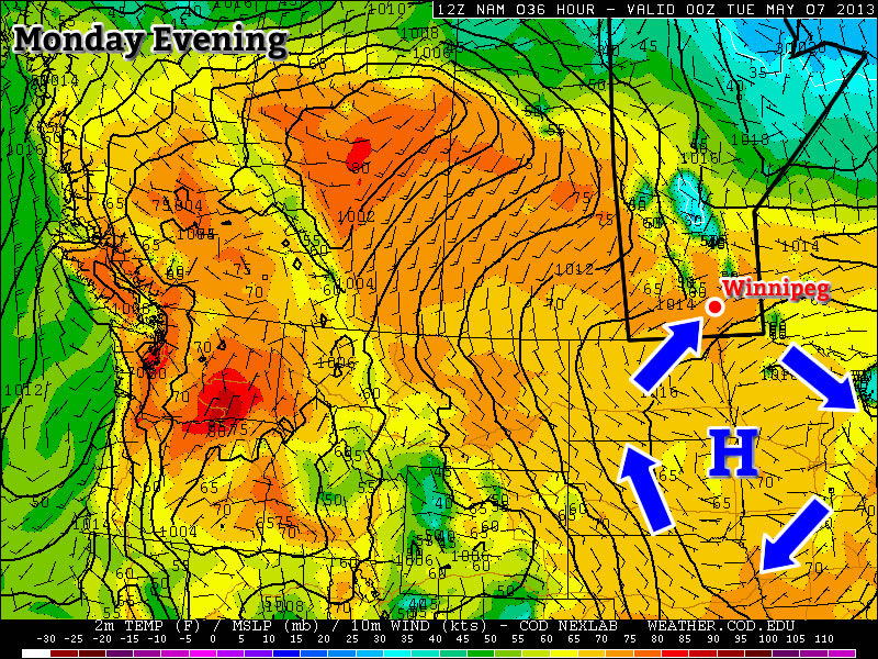
Pleasant Weekend Ahead

We’ll break out of the deep freeze today as things finally warm up a bit as we head into a mostly snow-free, pleasant weekend.

850mb Temperatures

850mb temperatures for this evening from the GEM-REG model. It’s clearly evident that a substantial area of warm air has pushed northwards over Southern Manitoba.

Yesterday’s 1-3cm of snow that fell across the city marked a shift in the long-wave pattern over the Prairies as the flow shifted from a west to northwest flow to a more southwesterly flow. This has allowed warmer air to flood over Southern Manitoba aloft, and as winds pick up this afternoon, we’ll get a chance to mix it down to the surface.

There will be a slight chance of flurries through the day today, but if they happen they’ll be quite light and very scattered about. Winds will pick up midday to around 20-30km/h, which will help mix down warmer air aloft and warm our temperatures up to around -6°C.

Skies will remain mainly cloudy tonight, and temperatures will remain steady near -6 or -7°C.

Winds will remain out of the south or southwest for most of the day tomorrow, keeping our temperatures around -6°C yet again. By late in the afternoon or tomorrow evening, the winds will shift around slightly to the northwest, which will allow our temperatures to drop to a low of -15°C overnight. We’ll be far from a deep freeze, though, as Sunday looks to bring sunshine back to Southern Manitoba as we climb to a daytime high around a more seasonal -10°C.

Light Snow Then A Return To Cold

Winnipeg seems to have found itself in the firm grip of winter as below-seasonal temperatures dominate the forecast. A low pressure system passing to our south today will bring snow and a slight moderation to our temperatures to near-normal values, but we’ll quickly drop back to well below-normal temperatures.

Storm-total liquid-equivalent precipitation accumulation

Liquid-equivalent (how much water there would be if you melted the snow) precipitation accumulation valid 18Z today.

A weak upper trough will swing through Southern Manitoba today, embedded within a strong northwesterly flow. While temperatures have warmed some 10-15°C aloft over the entirety of the Red River Valley, it looks like the surface warm front will halt part-way between Winnipeg and the U.S. border. Areas south of the warm front (probably areas south of Morris) will be able to tap into a southerly or even southwesterly flow, allowing temperatures to warm possibly as high as -5°C. Unfortunately for areas over the Northern Red River Valley, the warm front will likely remain well to our south, keeping our winds out of the southeast and slowly backing to northwesterly as the system passes by. These wind directions all favour the reinforcement of cold air as they tap into the colder air ahead and north of the low instead of the warmer air south of the low. That means that while there will be a slight increase in temperature from the advection (bringing in) of warm air aloft, a significant portion of the warming taking place over the Northern Red River Valley will be due to heat directed towards the surface from the clouds associated with this low. Highs north of the warm front will sit in the -12 to -15°C range.

Snow associated with this system pushed in overnight and will continue through the morning before tapering off around lunch time. Heaviest accumulations will lay north of the warm front with lighter accumulations south of the warm front. North of the warm front, including here in Winnipeg, we’ll see a total of 6-8cm of light, fluffy snow, while south of the warm front (the Southern Red River Valley) will probably only see a total of 2-4cm. There’s a slight chance that a few lingering flurries will hang on through the afternoon, but accumulations with those would be minimal should they happen.

Temperatures will drop down to around -25°C tonight as the clouds begin to break up and cold air filters southwards again in a northerly flow behind the low. Temperatures struggle to climb above -20°C tomorrow as we find ourselves deep in the cold air once again, some 8-10°C below normal for this time of year.

There are hints that temperatures may begin to moderate on Friday into the weekend, climbing as high as -9°C on Saturday, as a weak south/southwesterly flow develops. I’ll bite my tongue for now as models can sometimes be overly enthusiastic on moving the cold air out of the Red River Valley, but it does look like it’s at least a possibility. If that flow does develop, it’s likely we’ll see another batch of snow late this week as the warmer air pushes in. Until then, keep the long johns handy and be sure to check back in the comments below or follow along on Twitter for updates as the week progresses!

Cold and Calm

This week will start out cold and fairly benign. Our next chance for snow will come midweek.

Warmer air will be advected into Southern Manitoba on Tuesday night

Warmer air will be advected (moved in via wind) into Southern Manitoba on Tuesday night

After another cold morning on Monday, temperatures will warm up a bit during the day. Highs on Monday afternoon should be in the low to mid minus teens, a significant improvement from Sunday’s minus twenties, but still chilly. The wind will be a bit breezy from the south on Monday, but wind chills values won’t be significantly colder than the air temperature (except in open areas). A weak low pressure system will pass through Southern Manitoba on Monday night, bringing some cloud cover along with it. As a result, temperatures on Monday night will be warmer than those on Monday morning as the cloud prevents heat from escaping from the surface. Unfortunately, temperatures won’t increase much on Tuesday, as we only see temperatures rise a few degrees from the morning lows. Our next little warm-up will begin Tuesday night as an approaching low develops a southerly flow over Southern Manitoba allowing temperatures to rise overnight.

As the low moves into (or just south of) Manitoba on Wednesday, it will bring our next chance for snow. At this point models suggest we may see as much as 5 to 10cm from this system, or perhaps as little as 2cm. Additionally, there are indications that we may see another weak system pass by on Thursday, bringing another small bought of snow. At this point it is too early to say how much snow to expect from these systems, but 5 to 10cm in total for both looks like a good initial “guess”. More information about the potential for snow will be available as the week progresses.

Elsewhere in Weather News: December 8th, 2012

Typhoon Bopha Makes Landfall

(Follow-up to last week’s EIWN article “Typhoon Bopha Takes Aim at the Philippines”)

Typhoon Bopha made landfall on Monday, December 3rd, on the southernmost island of the Philippines. The typhoon was classified as a dangerous category five, where winds exceeded 250km/h. As expected with category five typhoons, the devastation and destruction caused extensive damage to infrastructure and crops; one fourth of the banana crops in the region were destroyed. As of Friday, December7th, it was reported that over 500 people had died as a result of the storm, and about 350 were still missing. Rescue workers are working feverishly, looking for survivors assumed to be trapped in their houses because of mudslides, or gold miners trapped in mines. In total, Bopha displaced about 250,000 Philippine residents who mostly took shelter in public buildings to ride out the storm. The Red Cross is providing funds and food to the ravaged country. Bopha appears to be the strongest, southernmost typhoon on record, to have ever affected this region of the Philippines.

Bopha

Infra-red satellite image of Bopha on Friday evening. It does not have a distinct eye and is showing signs of weakening. Forecast track is in white. (Source: CIMSS)

After Bopha made landfall in the Philippines, it emerged into the South China Sea and has re-strengthened to a category three hurricane with a well-defined eye. Its track has taken a northerly direction which was followed by a north-easterly track, which means its outer bands will affect the north-west islands of the Philippines later this weekend. Bopha will continue its somewhat circular track and is predicted to eventually head out in a south-westerly manner towards Vietnam next week. There is a lot of uncertainty as to what will happen after that, but there are some signs that show the storm will weaken off to a tropical depression.

Damage

Incredible damage in New Bataan, a southern Philippine city. (Source: AFP)

In other news, New Zealand experienced its deadliest tornado on record this past week where an EF-2 struck a suburb of Auckland and killed three people. It’s not a common sight to see such a strong tornado in Auckland but the conditions on December 6th greatly contributed to this, as warm, humid air, fueled severe thunderstorms in that area.

Short collection of videos of what it was like being inside the New Zealand Tornado. (Source: AP)