Milder Weather Returns for the Weekend

Winnipeg will see milder weather return today and near-seasonal conditions this weekend. Conditions will turn next week, though, as bitterly cold Arctic air descends into the Prairies.

RDPS Forecast 2m Temperature valid 21Z Friday February 17, 2022
Relatively mild conditions will move into the Red River Valley today with daytime highs near the freezing mark.

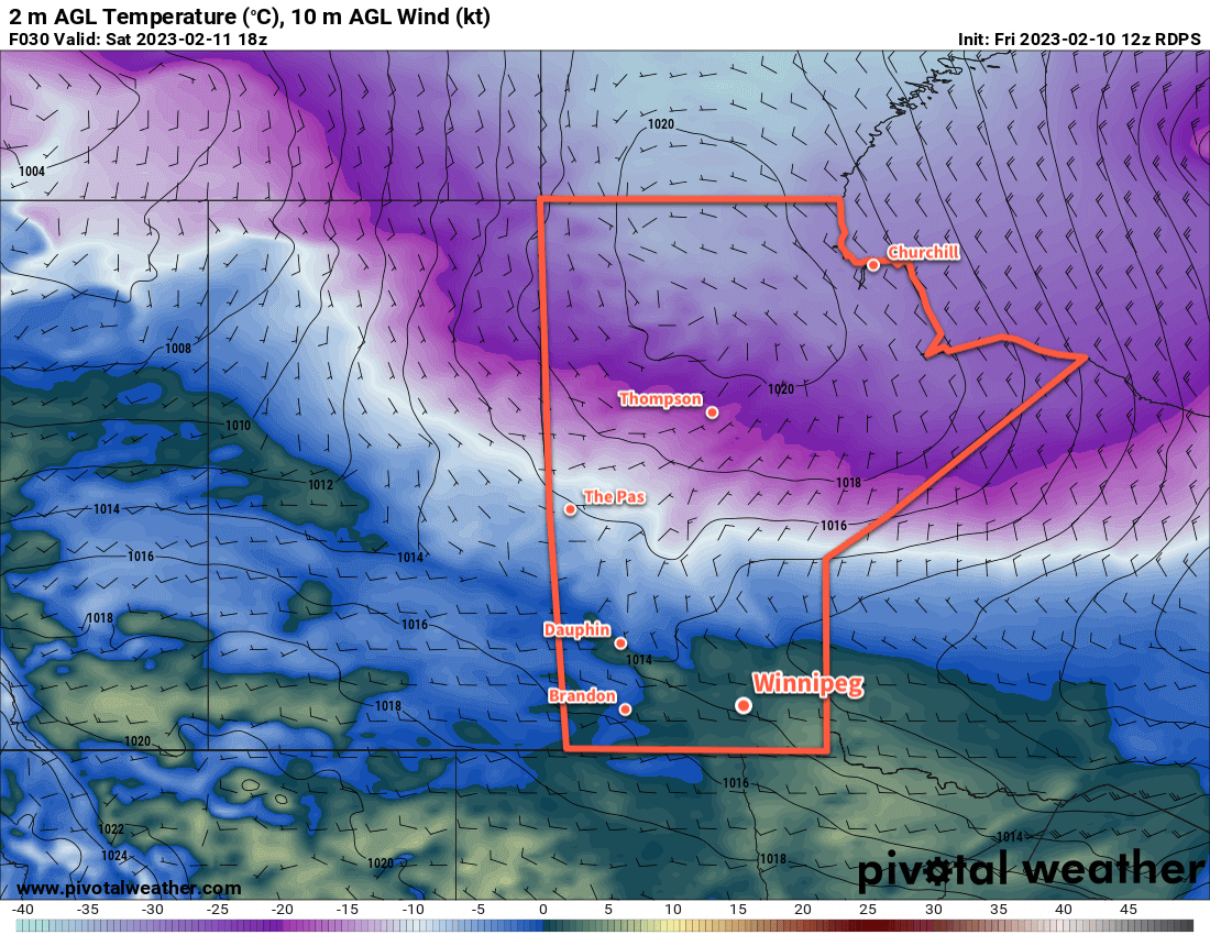
A low pressure system crossing the northern Prairies has brought a stiff southerly wind and warming temperatures to southern Manitoba today. With southerlies up near 40 gusting 60 km/h, temperatures rose through the night and will continue through the morning. The city should see a high near the freezing mark this afternoon as winds ease and turn westerly-northwest.

The region will see mixed skies today and there’s a slight chance of some light snow. Most of the precipitation will likely stay well north of Winnipeg, but some scattered areas of light snow might hang on along the trough as it moves through. Even if any precipitation does make it into the Red River Valley, no notable accumulation is likely.

A lingering chance of flurries will linger into the night as temperatures dip into the -10 to -15 °C range. The cloud cover should break up a bit overnight with easing winds.

On Saturday, more cloud will move back into the region as another weak low pushes into the region. There will be a slight chance of flurries through the day as temperatures rebound back to a high near -5 °C.

A band of light snow will likely work its way across the region on Saturday evening as a cold front sweeps into the region. A couple centimetres is possible as northerly winds pick up through the night. Temperatures will dip into the -10 to -15 °C range by Sunday morning.

To wrap out the weekend, northerly winds will continue as colder air pushes into the region. Some sun should reappear on Sunday with a below-seasonal high near -12 °C or so. More cloud will push into the region on Sunday night as another low approaches the region. Temperatures will be a bit cooler, though, with a low near -20 °C. Some light snow will push towards the region for Monday morning.

Long Range Outlook

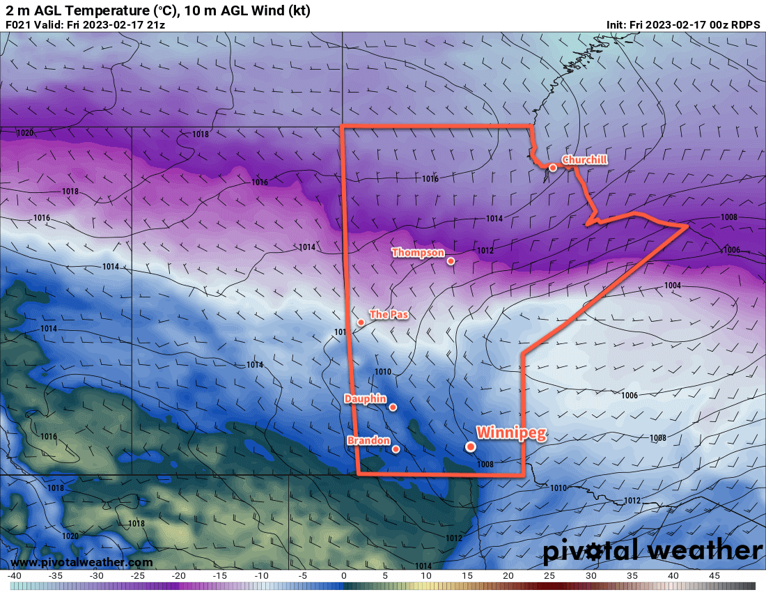
Winnipeg will likely see some light snow to start off next week. The high temperature will climb back to around -10 °C, but a cold front sweeping through later in the day will usher in northerly winds that bring a substantial change to the region.

Skies will clear as the system leaves on Monday night, and much colder weather will move into the region in its wake. Lows will dip into the -25 to -30 °C on Monday night. Heading into the rest of the week, daytime highs will drop to close to -20 °C with some -30 °C lows possible much of the week. 

Temperatures will begin to moderate slightly on Friday, with a more marked push towards seasonal values beginning next weekend.

Today’s seasonal daytime high in Winnipeg is -8 °C while the seasonal overnight low is -18 °C.

More Warm Weather Ahead for Winnipeg

Winnipeg will continue to see mild conditions with daytime highs close to the freezing mark through the weekend.

RDPS 2m Temperature Forecast valid 18Z Saturday February 11, 2023
Mild temperatures will move through southern Manitoba on Saturday with highs climbing above freezing in most areas.

A westerly flow aloft will continue to spread mild Pacific air across the Prairies this weekend. This will keep daytime highs seasonably mild in the Red River Valley and keep the storm track just to the north. As a result, Winnipeg and area will see a very pleasant weekend.

Temperatures will climb to around -2 °C in Winnipeg today with a breezy southerly wind near 30 gusting 50 km/h. Although a low pressure system is moving into Manitoba, skies will stay mainly sunny in Winnipeg as most of its cloud stays north of the RRV.

The area will see clear skies tonight as temperatures continue to rise to around +1 °C. The wind will ease overnight and shift to the west by morning.

For Saturday, the day will start off with sunshine and mild weather as temperatures climb a degree or two more. Some cloud will work into the region later in the day as a cold front slumps southwards into the Interlake. No precipitation will fall in Winnipeg, but some light snow or even a rain shower is possible further north.

Temperatures will dip to a low in the -5 to -10 °C range on Saturday night with clear skies.

Sunday will bring more warm weather to the region with a high just a bit cooler than Saturday. The region may see some cloud in the afternoon as a weak push of warmer air moves through.

Skies will clear out on Sunday night with a low again dropping into the -5 to -10 °C range.

Long Range Outlook

More warm weather is on the way for Monday with a light south wind and a high near 0 °C. Cloud will move in on Monday night as the next disturbance to affect southern Manitoba moves into the area.

Tuesday will continue to bring mild temperatures, but some flurries are likely later in the day as a cold front sweeps through the region. Some light snow will continue to be possible on Tuesday night as north winds pick up and usher in a much cooler air mass.

The flurries will taper off mid-week with highs dropping back towards seasonal values. Temperatures will likely stay near seasonal values into the weekend.

Today’s seasonal daytime high in Winnipeg is -9 °C while the seasonal overnight low is -19 °C.

Mild Weekend Ahead for Winnipeg

A push of Pacific warmth will bring cloudy and mild conditions to Winnipeg this weekend.

RDPS 2m Temperature Forecast valid 21Z Sunday January 15, 2023
A passing low pressure system will bring very mild temperatures to Winnipeg and the Red River Valley on Sunday.

A slow-moving low pressure system will push warmer air across the Prairies over the next few days. This warmer air will bring with it plenty of cloud cover — it definitely seems like we need to enjoy those fleeting moments of sun while we have them — as daytime highs rise towards the freezing mark.

Some morning sun today will give way to cloudier skies with a high in the -5 to -10 °C range. The cool morning temperatures in the -15 to -20 °C range will result in windy conditions this afternoon as the warmer air pushes in. Southerly winds will increase to around 40 gusting 60 km/h later this morning. Winds will ease later this afternoon, then the city will head to a low near -10 °C under cloudy skies.

Expect mainly cloudy conditions through the weekend with southeasterly winds near 20 km/h on Saturday and lighter on Sunday. Daytime highs will climb into the -5 to 0 °C range for both Saturday and Sunday as a low pressure system pushes into Saskatchewan. Overnight lows will also be quite mild near -5 °C. While the occasional few flakes are possible, any notable snow will stay north and west of Winnipeg.

The most organized area of snow will develop over Saskatchewan on Saturday evening and spread through WestMan and the northern Interlake on Saturday night. A swath of 5 to 10 cm is likely, with localized higher amounts possible as it moves into central Manitoba. The Red River Valley will stay mainly unaffected by this system.

Long Range Outlook

A few flurries will be possible on Monday as a cold front sweeps through the Red River Valley behind the passing low. Temperatures will begin to cool, with near-seasonal values returning for Tuesday. After that, though, milder air will again work its way into the region with daytime highs climbing back towards -5 °C by the end of the week.

For those missing the sun, the week ahead will continue to disappoint. Mainly cloudy conditions will persist through next week, though a few sunny breaks will be more likely on Tuesday.

While everyone’s tastes vary, the cloud cover is generally the trade-off needed for warmth at this time of year. Personally, I’ll take the trade-off of cloud for warmth as it makes getting outside and doing things so much more pleasant. But pretty soon even I’ll be willing to take the trade-off of a few -20 °C days for some blazing sunshine.

Today’s seasonal daytime high in Winnipeg is -13 °C while the seasonal overnight low is -24 °C.

More of the Same Ahead: Cloudy and Mild Weather

Sounding like a broken record, the days ahead shows little change with plenty of cloud and mild conditions.

RDPS 2m Temperature Forecast valid 21Z Friday January 13, 2023
Breezy southerly winds will develop across the Red River Valley on Friday as a push of very mild winter air approaches the region.

An upper ridge will rebound again over western Canada in the coming days, helping keep the colder Arctic air locked up north.

As a result, the region will continue to see seasonably mild weather. Daytime highs will sit in the -5 to -10 °C range through the rest of the work week. A weak disturbance will move through tonight will bring a chance for some light snow to the region, but it won’t leave much more than a dusting of snow across the Red River Valley.

A bit of cooler air will slump in behind this system on Thursday, sending highs towards the lower end of the range mentioned above. On the upside, that might also bring some sunny breaks to Winnipeg as well.

Winds will be a bit of a mixed bag over the coming days. Winnipeg will see southerly winds near 30 km/h today that will ease later this afternoon. They will then shift to northwest winds for Wednesday around 20 km/h and ease on Thursday. Friday could be a bit of breezy day as a more organized push of wamer air works towards the region. Much of the Red River Valley will likely see southerly winds of 40 to 50 km/h develop in the morning. Those winds will last through the day and then ease overnight.

Long Range Outlook

Skies will cloud back over for the weekend as a push of milder air moves into the region. Daytime highs will climb towards 0 °C by Sunday with a chance of some snow.

The snow will likely fall mainly north of Winnipeg from WestMan across the Interlake. There could be close to 10 cm of snow for some places by Sunday evening. We’ll keep an eye on this system as the week progresses. The southern edge of the snow amounts drop-off sharply, and more southerly track could mean poor travel conditions along the Trans-Canada Highway corridor on Sunday.

Until then, though, enjoy the mild conditions! If you’re looking for something to do to get out and take advantage of the winter warmth, The Forks Skating Trail is open on the Assiniboine all the way to the Osborne Bridge and on the Red River to Queen Elizabeth way!

Today’s seasonal daytime high in Winnipeg is -13 °C while the seasonal overnight low is -24 °C.