A ridge of high pressure will continue to bring ample sunshine and seasonably cool temperatures to Winnipeg.
Winnipeg’s forecast for the next few days is light work: seasonably cool and sunny. A stubborn ridge of high pressure will sit over the region the next few days. With little movement in the feature, the weather won’t change much either. The city will see plenty of sunshine with highs near 12 °C and lows around the freezing mark.
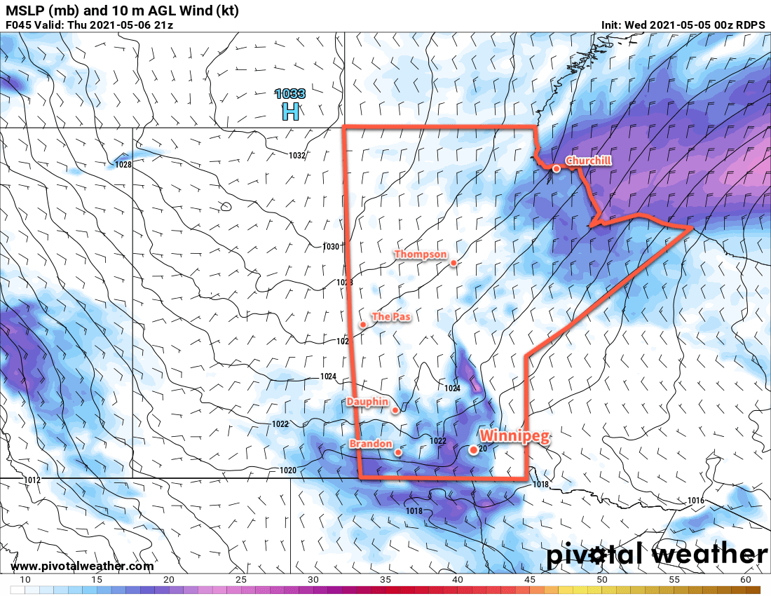
A broad area of high pressure over the Prairies will bring breezy conditions to southern Manitoba on Thursday.
Winds climb into the 20–30 km/h range today and the 30–40 km/h range on Thursday. They will ease each night and stay lighter on Friday as the ridge axis moves over the region.
Long Range Outlook
The region will see more of the same this weekend, then the pattern will break down next week. Forecasts show a return to seasonal temperatures early next week with partly cloudy conditions.
Today’s seasonal daytime high in Winnipeg is 17 °C while the seasonal overnight low is 3 °C.
Winnipeg will see seasonably cool spring weather this week with plenty of sunshine.
Winnipeg will see some lingering cloud with a chance of showers today in the wake of yesterday’s disturbance that moved across the region. The cloud cover will gradually break up through the day with the best chance for showers in Winnipeg late in the morning. The region will see a persistent north wind near 30 gusting 50 km/h through the day today. Temperatures will reach a seasonably cool high near 10 °C.
An area of high pressure extending from the Northwest Territories through southern Manitoba will dominate the weather pattern over the coming week.
A ridge of high pressure will build into the region tonight and bring clearing skies as the winds ease. Temperatures will head to a low near -3 °C.
This ridge of high pressure will dominate the weather pattern through the rest of the week. Winnipeg will see plenty of sunshine both Tuesday and Wednesday with highs near 10 or 11 °C and lows dipping just below freezing. Winds will pick up out of the north-northwest into the 20–30 km/h range each day and ease for the night.
Long Range Outlook
This ridge will stick around right into the weekend, bringing quiet weather and seasonably cool temperatures to the region. Forecasts show this pattern breaking down next week with seasonal temperatures returning. No rain is forecast.
Today’s seasonal daytime high in Winnipeg is 17 °C while the seasonal overnight low is 3 °C.
Temperatures will warm in Winnipeg over the coming days as milder air spread across the southern Prairies.
A strong upper-level flow will keep plenty of cloud cover over Winnipeg today. The cloudy conditions will keep things a bit cooler with a high near 12 °C. Winds will stay light out of the southeast through the day. The cloud will move out of the region tonight, leaving clear skies by Tuesday morning with a low near + 3°C.
On Tuesday, a dry trough of low pressure will move in, bringing with it a push of warmer air. Highs will climb into the upper teens under sunny skies with light winds. The cooler air will encroach on the region Tuesday night with temperatures dipping back to a low near +2 °C.
As long as winds are able to turn southerly, Winnipeg will see mild temperatures on Wednesday.
The cooler weather will be temporarily pushed northwards on Wednesday as a compact low pushes into the region from Saskatchewan. Winds will increase out of the south into the 20–30 km/h range with temperatures climbing close to 20 °C. The day will start off sunny, but the cloud will build into the region through the afternoon. The one caveat to highs will be that this system stays far enough north to bring a southerly flow to Winnipeg. If it slumps further south and Winnipeg’s winds stay light or northerly, then temperatures will likely only reach the low teens.
A cold front will sweep through on Wednesday night, bringing breezy northerly winds, cloudy skies, and a chance of showers or flurries. Temperatures will head to a low near the freezing mark.
Long Range Outlook
A ridge of high pressure will bring near-seasonal temperatures to the region on Thursday and Friday. Heading into the weekend, warmer weather is forecast to return, shifting the general weather pattern into seasonal mildness. Daytime highs right into next week are forecast to generally sit in the 15–20 °C range with overnight lows of 4–8 °C. The region should see plenty of sun, but a couple passing systems may bring some showers to the region later in the weekend into the beginning of next week.
Today’s seasonal daytime high in Winnipeg is 15 °C while the seasonal overnight low is 2 °C.
After a cool and windy Friday, temperatures will gradually return towards seasonal values in Winnipeg.
Today will start with moderate northerly winds behind a cold front that moved through overnight. Winnipeg will start off cloudy with north winds near 30 gusting 50 km/h. There will be a chance of flurries early followed by the cloud cover breaking up and clearing through the afternoon. Temperatures will climb to a high near 5 °C. A ridge draped across the region will bring mainly clear skies tonight with a low near -7 °C
The ridge will slide off to the southeast on Saturday, bringing mainly sunny skies to the region. Temperatures will recover a bit with a high near 8 °C and light winds. A few clouds will move in overnight with temperatures falling to a low near -1 °C.
The Prairies will see cooler temperatures on Friday in the wake of a cold front that moved through on Thursday.
Sunday will bring increasing cloud to the region as a long-wave upper trough begins to dig over western North America. Temperatures will nudge closer to seasonal values with a high near 11 °C as southerly winds strengthen to around 30 km/h. Skies should be cloudy by the afternoon and will stay so right through the night. A low pressure system moving into the region will bring a chance of rain to the region late overnight, but the main chance for organized rainfall will wait until Monday. Winnipeg will see a low near +2 °C on Sunday night.
Long Range Outlook
The new work week will start with cloudy skies and a chance of rain with a high in the upper single digits. After the low pressure system moves through, the forecast shows variable cloudiness with temperatures warming into the mid- to upper teens.
Today’s seasonal daytime high in Winnipeg is 13 °C while the seasonal overnight low is 1 °C.