Weekend Storm To Bring Snow & Warmer Weather

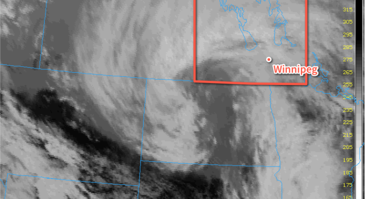
Warm weather is on the way for Winnipeg this weekend as a strong low pressure system developing over Northern Alberta spreads mild air eastwards through the Prairies. This storm system will then slide southeastwards across the Prairies, bringing a moderate snowfall event to Manitoba primarily through Saturday afternoon and Sunday, followed by falling temperatures, gusty winds and blowing snow.

Winnipeg will see mainly cloudy skies today as the city remains locked underneath a tight baroclinic zone. [1] There will be a continued chance of occasionally seeing some of the flurry activity that developed last night over the city, however no real accumulations of snow are expected today. Temperatures will be fairly pleasant with a daytime high near -6°C, which is 4°C above the normal high of -10°C for this time of year.

The chance for any flurry activity will diminish tonight, but the cloud will stick around as temperatures dip to around -11°C for the overnight low.

Storm System Moves in on Saturday

Saturday will bring the arrival of both warmer weather and the storm system that will bring a new batch of snow to the region. First the good news: temperatures will be on their way up through the entire day. From the morning low near -11°C, temperatures will gradually climb to near -5°C midday and then up to near -1°C by evening. Temperatures will then remain fairly steady through the night, wavering around the -1°C mark. Cooler air will begin working into the region on Sunday, dropping the temperatures in Winnipeg to around -8°C by the evening.

AWM Snowfall Forecast for February 6/7, 2016
Updated AWM Snowfall Forecast for February 6/7, 2016 (Original here)

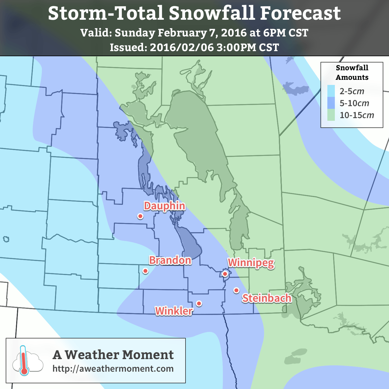
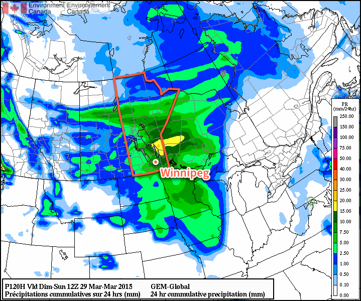
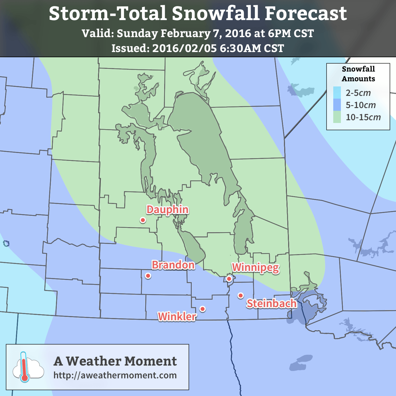
While some flurries are possible through the morning, the real snow will develop through the afternoon hours as the low centre of the storm begins moving into Southern Manitoba. Snow will intensify into the evening and the heaviest snow of the storm will be through Saturday night. On Sunday morning the snow will likely begin to ease, but continue to persist much of the day. By the time all is said and done, it looks quite likely that essentially all of Southern Manitoba will have seen at least 5cm of new snow before things taper off on Sunday night.

The heaviest amounts will fall to the north of the low track, which, given that it’s still a day and a half out, could change. The current agreement seems relatively dependable, however if it does end up shifting south even just a little, it’s possible that Winnipeg could surpass 10cm.

Although this system has the potential of producing a lot of snow, it doesn’t look like it will qualify for a snowfall warning from Environment Canada, which requires 10cm to fall within a 12hr. time period. This system will produce higher amounts more through it’s longer residency time than its intensity. That said, it’s still early for a lot of things with systems like these; we’ll be keeping an eye on it and updating forecasts if it looks like it’s going to change significantly from current expectations.

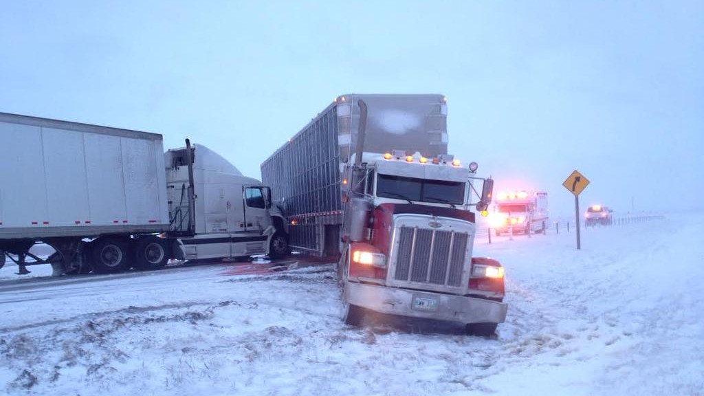
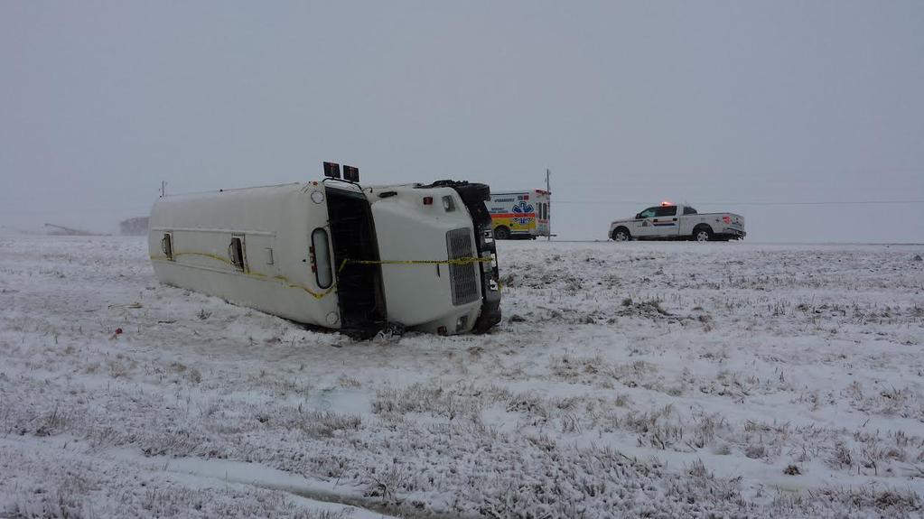
Lastly, there will be a bit of wind with this system too. Winds won’t be too bad on Saturday, however for a short while in the afternoon winds may climb up to around 30-40km/h out of the southeast. Winds will diminish overnight before picking up on Sunday out of the northwest. Blowing snow will be an issue on Sunday as the northwesterly winds increase to 40 gusting 60km/h and combine with the fresh snow. Through the Red River Valley, the strong winds will be in place by mid-day Sunday and persist into the late evening hours, so if you have plans to travel on Sunday afternoon or evening, prepare to give yourself some extra time to account for poor visibilities and driving conditions. For those reading this in southwestern Manitoba, the stronger winds will be in place by Sunday morning and persist into the overnight period as well, making blowing snow an issue all the way west into southeastern Saskatchewan.

Long Range: Colder Weather…But Only Briefly

Behind this storm system, cooler air will begin slumping into the Prairies, returning temperatures to seasonal values. Another batch of snow is possible Tuesday night as another disturbance moves through the region, which will usher in a pattern change that will see southwestern Manitoba clipped by several systems while even colder air works into the Prairies.

NAEFS 8-14 Day Temperature Anomaly Forecast — Valid February 13-20, 2016

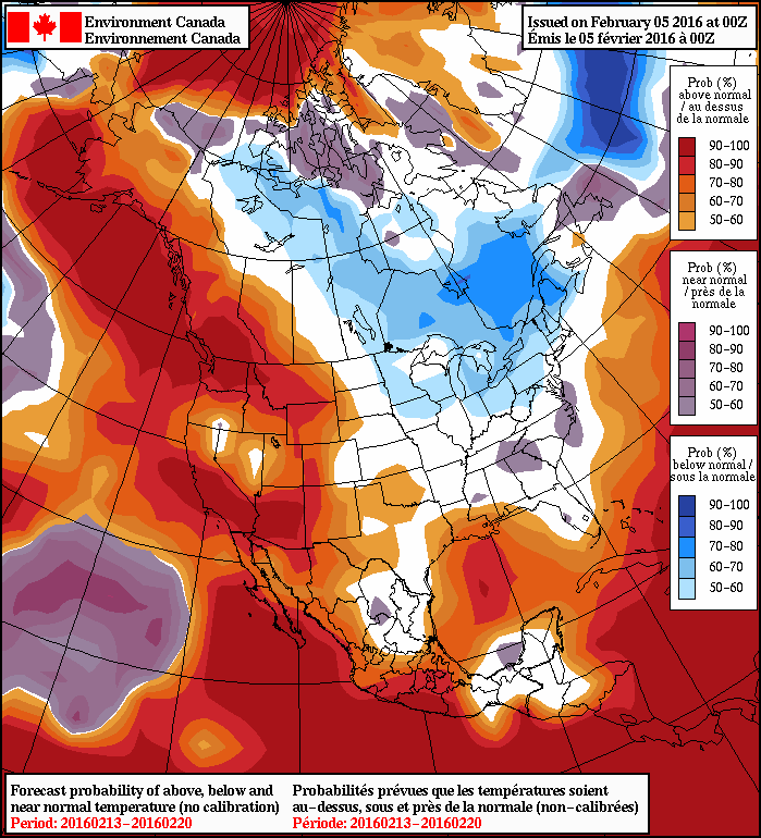
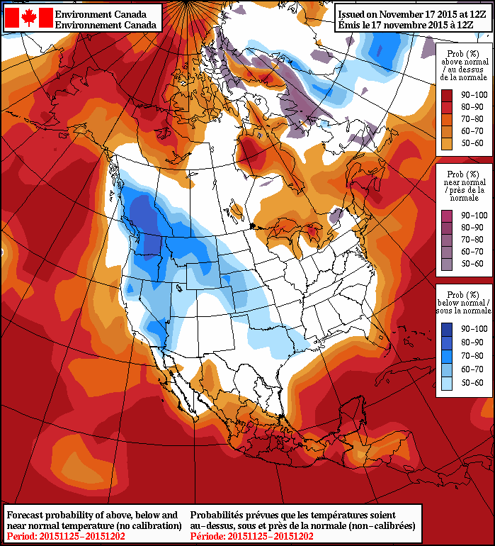
Into the second half of next week, below-seasonal temperatures will begin moving into the province with daytime highs slumping into the low minus teens and overnight lows dipping below -20°C. This cooler weather will likely persist into the early parts of the following week before a moderating trend begins, shown by the higher probabilities of cooler-than-normal weather in the NAEFS forecast above.

The seasonal daytime high for February 5th in Winnipeg is -10°C, while the seasonal overnight low is -21°C.


  1. A baroclinic zone is an area where there is a strong temperature gradient across relatively short distances, either at the surface or aloft.  ↩

First Major Snowstorm of the Winter Incoming

Southern Manitoba has its first major snowstorm of Winter 2015/16 on the doorstep as a Colorado Low moves northeastwards through the American Plains and is poised to produce 10–20 cm of fresh snow through the Red River Valley.

The incoming Colorado Low has spread snow across South Dakota this evening which is now pushing into North Dakota and Minnesota. This area of snow will intensify as it heads northwards courtesy a steadily organizing weather feature called an inverted trough. This trough of low pressure extends north/northwest out from the centre of the Colorado Low and will draw moisture into the Red River Valley and produce a swath of heavier snow through the region.

Mayville RADAR @ 10:29PM CST on December 15, 2015
At 10:29PM CST, Mayville RADAR in North Dakota shows a broad area of snow pushing northwards towards Manitoba.

At this point, it looks like the snow will begin pushing across the U.S. border sometime between 2 and 4 A.M. and then spread into Winnipeg before 4 and 6 A.M.. The heavier snow will build into the Red River Valley between 6 and 9 A.M. and persist until near lunch time. Through the first half of the day, as much as 10 cm could fall; that’s a fairly intense snowfall rate and will undoubtedly have significant impacts on transportation. The snow will ease slightly for the afternoon, but still be fairly persistent, dropping another 2–5cm or so.

Winnipeg Forecast Sounding for 11Z December 16, 2015
The forecast soundings for Winnipeg on Wednesday morning show very favourable thermodynamic profiles for moderate to heavy snow.

Heading into the evening and overnight hours, the snow will begin to become a little bit more disorganized save for one area known as the deformation zone. This feature will be the western-most extent of the snowfall and will typically have slightly more organized precipitation along it. Best indications at this point are that the deformation zone will line up through the Interlake and Red River Valley, meaning it’s fairly likely that more persistent light snow will last through the night. This snow could produce anywhere from 1–3cm more.

AWM Snowfall Outlook for December 15-17, 2015
AWM Snowfall Outlook for December 15-17, 2015 with verification overlaid.

By Thursday morning, the snow should be tapering off to flurries and moving out of the region. When all is said and done, it’s likely that anywhere from 10 to 20cm of fresh snow will have fallen in the Red River Valley. Localized amounts could possibly exceed 20cm in a few particular locations, namely anywhere that may see upslope enhancement in the northerly winds: the western escarpment of the Red River Valley and north side of Turtle Mountain being to of the most likely places. These higher amounts would be very localized, though, and are not reflected in the above snowfall forecast, which is looking more at large-scale snowfall totals.

Snowfall Warning Highlights
The highlights of this Colorado Low storm system

Environment Canada has issued a snowfall warning arcing across the Red River Valley with the discussion showing very similar thinking: 10–20cm of snow, heavy first thing Wednesday morning, then blowing snow and cooler temperatures heading into Thursday.

Cooler with Blowing Snow Behind the Colorado Low

Beginning Wednesday evening, northwesterly winds will begin moving into southern Manitoba. Despite the cooler temperatures pushing in and the relatively strong winds aloft, winds will likely only reach around 30 gusting to 50 km/h overnight.[1]

By Thursday morning, the wind will strengthen to 40 gusting 60 km/h, which when combined with the fresh snow, will almost undoubtedly produce fairly widespread blowing snow through the Red River Valley. These stronger northwesterly winds will also be ushering in a much cooler air mass that will drop temperatures to –20°C by Saturday morning.

This colder weather, while an abrupt change from what we’ve been seeing for the past month and a half, is actually not all that uncommon. Normal daytime highs for Winnipeg this time of year are around –10°C with normal overnight lows near –20°C. So while we’ll see temperatures dropping 10–15°C, they’ll be seasonal to just slightly below seasonal for this time of year.

Fortunately this cold snap will be brief. Early next week it looks like a weak system will move through bringing a chance for some light snow and a return to slightly above-seasonal temperatures.


  1. This is due to the cyclonic curvature of the surface pressure gradient which can act to diminish wind speeds.  ↩

Winter Arrives

Environment Canada made headlines with the special weather statement for Winnipeg issued Monday with a referential start: winter is coming. And how.

Today will mark the beginning of a harsh slide into winter after a essentially a month of temperatures well above seasonal for this time of year. The change in the pattern will be brought courtesy a rather peculiar weather setup that will see a relatively weak Colorado Low moving north through Minnesota into Northwestern Ontario merge together with an Alberta Clipper quickly moving eastwards across the Prairies. Each system is moderately potent in their own right, but when combined, they will form a new storm system that will rapidly intensify, driving strong northwesterly winds through the province alongside the first significant snowfall for many regions of Southern Manitoba.

Today will start deceptively. Relatively light winds and temperatures climbing towards 5 or 6°C will give a false sense of security betrayed only by the increasing cloud cover that will build in through mid-day into the afternoon. Some light rain will develop over the Red River Valley this afternoon, which will mark the end of our above-seasonal temperature streak and usher in winter. As the rain moves into the region, winds will pick up out of the northwest to around 50km/h sustained with gusts as high as 70–80km/h. The rain will switch over to snow sometime in the evening and likely begin piling up fairly quickly as the strong winds rapidly cool the ground and other surfaces.

The strong winds and snow will persist through tonight as temperatures dip down towards –3°C or so as colder air begins filtering into the region. With snow piling up and such strong winds in place over the Red River Valley, it’s quite likely that driving conditions become quite poor as roads freeze, become ice covered, and see reduced visibility in blowing snow.

AWM Snowfall Forecast issued November 18, 2015
AWM Snowfall Outlook issued November 18, 2015

Thursday will continue to bring light snow and strong winds to the region as temperatures remain around –4°C or so. The winds will be a bit lighter than at their peak, but will likely remain near the 40 gusting 60km/h mark through much of the day before beginning to taper off in the evening. Overnight, other than some lake-effect snow streaming southeastwards off of Lake Winnipeg, there’s likely to be just a few flurries lingering in the region. Temperatures will dip down to –6°C for the overnight low.

In general, around 5–10cm of snow is likely to fall with this system through southeastern Manitoba, the Red River Valley and northwestwards into Parkland Manitoba. Exact amounts will depend on the timing of the change-over from rain to snow and how quickly the snow begins accumulating instead of melting on the ground.

Friday will be a mainly cloudy day with just a very slight chance of light, scattered flurries. Temperatures will recover only a degree or two from the overnight low with highs around –4°C. There may be a few clear breaks through the Red River Valley on Friday night, but overall there will still be a fair amount of cloud as temperatures head towards an overnight low near –10 or –11°C.

Colder Weather Continues Through The Weekend

The cooler weather, which while a significant drop from what we’ve been experiencing is, in actuality, just a couple degrees below seasonal values for this time of year, will persist through the weekend.

NAEFS 8-14 Day Temperature Anomaly Outlook valid for November 25 to December 2, issued 12Z November 17, 2015
The NAEFS is showing a trend towards seasonal temperatures for the remainder of November.

Daytime highs around –5 or –6°C will be in place over Winnipeg & the Red River Valley this weekend, with a chance of some more flurries on Saturday improving to sunnier fare on Sunday. Overnight lows will be in the low minus single digits. So, while it may be a huge change from the weather we’ve been having, we’ll be shifting to more seasonal weather for the end of November.

IR Satellite Image of Late-March Storm over the Southern Prairies

Winter Storm Slams Manitoba

A potent spring storm is moving into Manitoba today and will likely exit the region known as one of the strongest of the Winter 2014/15 season. This storm has already brought drizzle, rain and freezing rain to southwestern Manitoba & the Red River Valley and will end up delivering the whole wintery mix by the time all is said and done. Environment Canada has issued a swath of heavy snowfall warnings and special weather statements across Manitoba in advance of this system.

Tuesday Night

Tuesday Night
-1°C
Rain changing to snow

Rain will redevelop this evening and persist through much of the overnight period until a cold front pushes through the Red River Valley and switches the precipitation over to snow. Many areas in the Red River Valley will see around 5-10mm of rain. Alongside the switchover to snow, strong northwesterly winds to 40-50km/h with gusts as high as 70km/h will begin to move into the Red River Valley. The combination of falling snow and strong winds, coupled with the temperature dropping below zero overnight after a day of melting, drizzle & rain will likely produce very poor driving conditions with slippery roads & poor visibilities in blowing snow by Wednesday morning.

Wednesday

Wednesday
⇒ -2°C / -11°C
Snow ending in the afternoon; windy

Snow will continue through Wednesday morning before beginning to taper off through the afternoon with a further 5-10cm possible for the City of Winnipeg and the Red River Valley. As mentioned before, the snow will be accompanied by strong northwesterly winds to 40-50km/h which will produce a fair amount of blowing snow as well. Temperatures will drop just barely to -2 or -3°C through the day. Given the relatively mild temperatures, it’s quite likely that as soon as the snow begins to taper off, the blowing snow will too; falling snow will be needed to produce it and it’s unlikely we’ll see much ground-based blowing snow after the fact. Winds will begin to taper off late in the afternoon or in the early evening as the storm moves off into Ontario. Left behind the storm will be partly cloudy skies as temperatures drop to around -11°C.


Storm Update

As expected, many regions across Manitoba saw a significant dump of snow overnight and into this morning. Snowfall totals to 10:30AM CDT across Manitoba are:

Location Snowfall Amount
Winnipeg 5cm
Portage la Prairie 5-10cm
Brandon 6cm
Steinbach 5cm
Dauphin 15-25cm
Rossburn 20cm
McCreary 18cm
Neepawa 15cm
Fisher Branch 15cm
Roblin 14cm
Elkhorn 10cm
Argyle 10cm
Swan River 8cm
Miami 6cm
Morris 2cm

In addition to the heavy snow, many areas through the Red River Valley saw several hours of rain last night. Here in Winnipeg, around 8mm fell overnight, and preliminary reports indicate that similar amounts were seen through much of the Red River Valley. In addition to the snow and rain, very strong winds to 50-60km/h moved into Red River Valley this morning producing blowing snow and helping make sure roads are slick.

The winter weather has wreaked havoc on area infrastructure with numerous accidents on highways as well as complications to power infrastructure with numerous pole fires & power line damage events reported. Many motor-vehicle collisions were reported on Manitoba Highways, with several resulting in sections of Highways 1 and 75 being closed. Two of the more significant ones, pictured above, involved a jackknifed semi-truck collision near Elie and a school bus rollover near Ste. Agathe on Highway 75.

Conditions have begun to improve in the Red River Valley; winds remain strong however with the snow finally moving off into Ontario, much of the blowing snow has stopped. Road conditions will continue to be poor through the remainder of the day, so if you are driving, especially on area highways, be sure to give yourself extra time and be cautious.


Thursday

Thursday
-6°C / -11°C
Partly cloudy

Thursday will be a mainly sunny day – perhaps just a few lingering clouds – with a cool high of just -6°C. Winds will be light, so with the increasingly strong March sun it may not actually feel all that bad outside. Even with the sub-zero temperatures, expect plenty of melting to happen. We head into Thursday night with clear skies and cool off to around -10 or -11°C again overnight, although that could be a couple degrees warmer depending on when cloud cover arrives from…

Friday

Friday
-3°C / -8°C
Mainly cloudy with a chance of light snow

Friday will bring mainly cloudy skies as clouds push in either early Friday morning or late overnight on Thursday thanks to a system rippling through Southern Manitoba from the northwest. It will most likely produce a band of snow through portions of the Parkland, Southwest and into the Western Red River Valley. Under this band, accumulations of 1-2cm look possible at this time. There’s a little uncertainty as to the exact track, given that it’s 3.5 days out at this point, so it may end up a little further west or east. With the current “most likely” track, Winnipeg sees a fairly decent chance at some flurries but little in the way of accumulations. Temperatures will climb to around -3°C with fairly light winds. Friday night looks pleasant with light winds again and a low near -8°C.

Long Range

It’s looking as if another storm is possible on Saturday night as a shortwave tracks across Manitoba.

GDPS 24hr. QPF Forecast valid 12Z Sunday March 29, 2015
The GDPS is forecasting a fair amount of precipitation associated with a significant storm moving through Manitoba this weekend.

Fortunately, it seems like it will be bringing enough warm air with it that precipitation would fall as rain. Either way, though, it looks like we’ll see plenty of cloud and wind this weekend. After a long spell of little in the way of weather, it looks like a typical, more active springtime pattern is setting up!