Cloudy, Cool Mid-Week Gives Way to Another Heat Wave

Temperatures will be well below-normal today as Winnipeg and the Red River Valley remain entrenched under a cool northeasterly flow behind yesterday’s low that moved through the region. Temperatures will rebound quickly, though, with well above-normal temperatures return for the end of the work week.

Today will see high temperatures some 10°C below typical seasonal as cool, cloudy weather hangs over the Red River Valley as northeasterly winds tap cooler air underneath a cold upper-level low crossing over the region. Skies will remain cloudy much of the day — there’s a slight chance we might see some sunny breaks late this afternoon — and there will be a chance for some light rain or drizzle, particularly in the morning hours. Temperatures will reach a high of only around 16°C1 with winds out of the northeast at 15-25 km/h.

Skies will begin to clear tonight as temperatures dip to a low near 11°C with light winds.

A cold low, shown here with closed height contours at the 700mb level, will move across southern Manitoba on Wednesday, keeping skies cloudy and temperatures cool.

Thursday will be a much nicer day as the remaining cloud cover clears out and temperatures climb to a high near 23°C under light winds. There may be some scattered clouds in the afternoon, but nothing that will spoil the sunshine. Expect clear skies on Thursday night as temperatures drop to a low near 13°C.

On Friday, the upper-level ridge that brought scorching hot weather to B.C. and the western Prairies last week begins building back into the region. Under sunny skies, temperatures in the Red River Valley will climb into the lower 30’s. Areas in the southwest corner of the province will be even hotter, with high temperatures climbing into the mid- to upper-thirties. Southerly winds at 20-30 km/h will be in place as a low pressure system slumps towards the region from the northwest. These winds will draw humid conditions northwards; by the end of Friday dew point values will climb into the low 20’s, making it feel positively muggy out there.

Very warm temperatures will build across the entirety of the Southern Prairies on Friday with highs in the 30’s.

Friday night will continue to be warm with lows dropping only to around 18°C.

Long Range

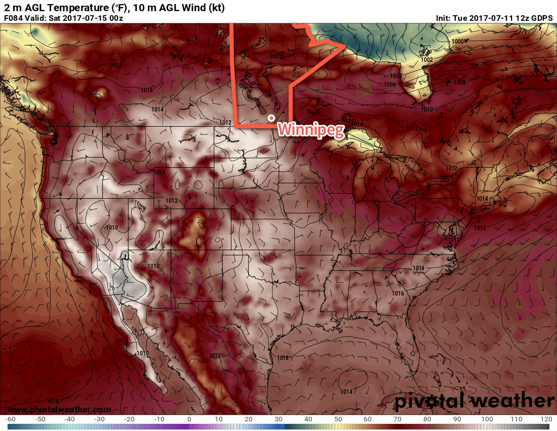
Northerly winds will move into the region on Saturday, flushing the humidity southwards and making for more comfortable conditions. Daytime highs will still remain in the upper 20’s or low 30’s throughout the weekend under mainly sunny skies. With the warm air still in place, overnight lows will still be quite warm, likely bottoming out in the upper teens.

The hot weather continues next week, but there are signs that there may be some unsettled weather to begin the week before things settle down again. No significant widespread rainfall is expected in the next week.

Winnipeg’s seasonal daytime high is currently 26°C while the seasonal overnight low is 13°C.


  1. Although if more clearing were to develop than expected, temperatures would quickly reach closer to 18 or 19°C. 

Mild, Sloppy Weekend Ahead

Winnipeg will see a mild weekend with temperatures continuing well above-normal, but a developing trough of low pressure will bring unsettled weather to the region.

Today will mark the beginning of a soggy weekend as temperatures hovering just above the freezing mark persist over the next several days.

Temperature-wise, expect temperatures to be within a degree of +1°C all the way until Monday morning, when it will dip just below the freezing mark. Alongside those mild temperatures will be overcast skies through the entire weekend.

We’ll an almost-continuous chance of precipitation of some sort. Today will bring dissipating fog patches this morning and a chance of drizzle through much of the rest of the day. A impulse heading northwest out of Minnesota will move across the region this evening, bringing an area of rain showers through the Red River Valley with amounts of 2-5 mm expected. After it passes tonight, fog patches will likely redevelop. Saturday will see a chance of showers or drizzle throughout the day and night.

An area of rain and snow will move through the province tonight, starting near Sprague and heading northwest towards Flin Flon.

That chance for light precipitation will continue through Sunday, but slightly cooler temperatures moving in mean that some flurries may mix into things.

Long Range

Not much will change through the first half of next week; cloudy conditions with temperatures near the freezing mark will continue with chances for light precipitation continuing.

Mild Conditions Continue

The remainder of the work week will be marked by daytime highs climbing above 0°C, continuing an above-normal temperature trend that has persisted through every single day so far this November.

Today will be damp but mild as stratus cloud bringing drizzle and fog lingers throughout the region. A few isolated flurries may also be thrown into the mix as well, but we’re done with any accumulating snow for now. We should reach a high temperature of +2°C, which will continue to melt the snow that fell yesterday morning across the city. Winds will be light out of the northwest at 10-15 km/h. Expect cloudy skies tonight with a continued chance of drizzle or freezing drizzle alongside fog patches. Tonight’s low should be near -1°C.

Thursday will likely be more of the same with low-level moisture trapped under a slack flow. Temperatures will reach a high near +2°C with light winds. There will be a very slight chance of some patchy drizzle or fog. For Thursday night, skies will remain mostly cloudy until some clearing begins working in late overnight. Temperatures will dip to a low near -2°C.

This forecast sounding for Thursday afternoon in Winnipeg shows a deep layer of saturated air in the lower atomosphere.

Friday will likely bring some sunshine back to the region with more above-normal temperatures on tap as the daytime high climbs to +2 or +3°C. Skies will gradually clear through the day and things should finally start to dry out a bit. Winds will be light out of the south.

Tuesday Snow Breaks Record

While the actual snowfall event that began early in the morning on Tuesday November 22 was unimpressive with just 2-5 cm of fresh snow accumulation across the city, it managed to break a long-standing record: the latest day of first measurable snowfall.

RankDate of First Measurable Snowfall (≥ 0.2cm)Year
1November 222016
2November 211963
3November 201953
4November 191931
5 tie
5 tie
November 18
November 18
1880
2015
7November 171890
8November 161977
9November 151903

Yesterday’s snowfall was the latest in the year Winnipeg has seen its first fall/winter snow in the 144 year old record that dates back to 1872.

Long Range

The weekend looks quite nice with a fair amount of sun and mild temperatures with daytime highs continuing slightly above the freezing mark. Heading into next week, though, it appears another significant winter storm may be brewing. Some long-range models are hinting at the possibility of 10-25 cm over the Red River Valley through the first half of next week, but it’s still too early to really comment on how accurate any of those predictions will be.

That said, the continued significant story is the above-normal temperatures that have been in place the entire month of November and continue to be forecast through to the end of the month. If we do indeed see high temperatures close to what is currently forecast, November will be in the contest for the warmest November on record!

Winnipeg’s seasonal daytime high is currently -4°C while the seasonal overnight low is -13°C.

Mixed Conditions Mark Transition to Cooler Weather

Today will bring a mixed bag of conditions to Winnipeg and area before a cold front sweeps through the region this evening and ushers in cooler air from Northern Manitoba.

We’re off to a misty, drizzle-filled start to the day here in Winnipeg thanks to a large area of stratus cloud that expanded northwards out of the Dakotas overnight. This expansive area of cloud—stretching from southeastern Saskatchewan across southern Manitoba and into northern Ontario—will remain in place until later this morning; by midday, westerly winds will begin building into the region and help to break up the clouds and bring an end to the fog patches and drizzle.

The sun should make an appearance in Winnipeg this afternoon as temperatures head towards a pleasant high of 20°C. The sunshine will be relatively short-lived as a cold slumping southwards out of central Manitoba spreads another batch of cloud southwards.

GDPS 850mb Temperature Forecast valid 00Z Thursday April 21, 2016
A cold front separates above-normal temperatures in southern Manitoba from well below-normal temperatures pushing southwards through northern Manitoba.

When the cold front slides through this evening, there will be a slight chance of an isolated shower or thundershower. This activity is not expected to be particularly widespread and will taper off very quickly once the sun begins to set. Breezy northerly winds of 20-30 km/h will move in behind the front ushering in cooler air that will send Winnipeg’s overnight low to near +2°C.

Thursday will be a pleasant but cool day with just a few clouds and a high near 8°C. Winds will continue to be breezy in the morning at 20-30 km/h, but will gradually taper off through the day. Expect an overnight low near -1°C with increasing cloud.

Friday will bring mainly cloudy skies as a frontal zone sets up across the eastern Prairies. Winds will be light and there will be just a slight chance of some light shower activity. Expect a high near 8°C once again and an overnight low near +1°C.

Winnipeg’s seasonal daytime high is currently 13°C while the seasonal overnight low is 0°C.