Warmth Continues Until Friday, Then Unsettled

Winnipeg will see another couple days of beautiful warm weather before a large-scale pattern change brings cooler and unsettled weather back to the region.

The upper ridge that brought highs close to the 30 °C mark yesterday will continue to bring seasonably hot conditions for a couple more days. Winnipeg will see breezy southerly winds near 30 gusting 50 km/h over the next couple days as temperatures climb to highs in the upper 20s. Solidly in the warm air, Winnipeg will see another mild low near 16 °C tonight, but temperatures will dip a tad cooler on Thursday night as the warm air begins to move off to the east. The city will see sunny skies today while Thursday will start sunny with cloud moving in through the afternoon.

RDPS 2m Temperature Forecast valid 06Z Friday October 8, 2021
A cold front will push across southern Manitoba on Thursday night.

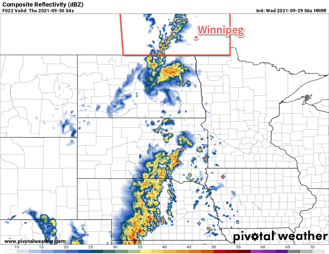
On Friday, an upper trough moving in from the west coast will push a cold front into southern Manitoba. At the same time, a shortwave will lift out of the Dakotas and will support an area of rain that will move to the northeast. These two things combined will bring cooler, cloudier weather to Winnipeg as winds shift to the north. The city will see a high near 18 °C on Friday with a good chance of rain through the day. The chance for a bit more rain will continue on Friday night as temperatures dip to a low near 12 °C.

Long Range Outlook

Friday marks the beginning of a shift to a much more unsettled pattern that will persist through the weekend and into next week. More rain is likely this weekend with the potential for some more organized accumulations across the region. Conditions will settle with mild temperatures to start next week, then another large storm system is forecast to move in mid-week, bringing the potential for a substantial rainfall and a return to seasonal temperatures.

Today’s seasonal daytime high in Winnipeg is 13 °C while the seasonal overnight low is 2 °C.

Another Hot Day; Seasonably Warm Temperatures Continue

Summer-like weather will persist through the end of the week, sending September 2021 off with beautiful conditions.

A potent upper-level ridge will bring another hot day to southern Manitoba today. Temperatures will climb up to the 30 °C mark again today with breezy southerly winds near 30 gusting 50 km/h. The region will see plenty of sunshine today despite a bit of cloud building in through the day.

It will be a mild night with a low near 15 °C as the winds ease. A cold front will gradually slide across the Red River Valley overnight, bringing a chance of showers or thunderstorms to the region with it. Most of the activity will likely stay over the western portion of the valley, but a few showers may push eastwards early Thursday. By Thursday morning, Winnipeg will see mostly cloudy skies with a light northwest wind.

HRRR Simulated Reflectivity valid 04Z Thursday September 30, 2021
Scattered showers and/or thunderstorms will lift northwards through the western Red River Valley along an advancing cold front on Wednesday evening.

The system bringing the unsettled conditions will be tracking eastwards slowly on Thursday, bringing mainly cloudy skies to the region. There will be just a slight chance of an isolated shower or two through the day. Temperatures will be cooler but still well above seasonal averages with a high near 20 °C. The cloud cover should break up on Thursday night as temperatures head to a low near 8 °C.

A ridge of high pressure will bring sun back to the region on Friday. Winnipeg will see light northerly winds and a high near 22 °C. Temperatures will dip to a low near 6 °C on Friday night under mainly clear skies.

Long Range Outlook

The region will see beautiful weather this weekend with highs in the low 20s, partly cloudy skies, and light winds. Lows will sit in the upper single digits. The mild weather will continue into next week.

Today’s seasonal daytime high in Winnipeg is 15 °C while the seasonal overnight low is 4 °C.

Scorching Summer Weather Returns

Temperatures in Winnipeg will soar through the first half of the week as summer returns in full force.

A potent upper-level ridge building over the region will bring temperatures well above seasonal values to wrap up September in southern Manitoba. With plenty of sunshine, temperatures will climb from the mid-20s today to near 30 °C on both Tuesday and Wednesday. Rather unusual for late season heat will be that it won’t be overly windy. The city will see southerly winds up to 30 gusting 50 km/h this afternoon that ease overnight, lighter southeast winds for Tuesday, then southerlies back up to 30 gusting 50 km/h on Wednesday.

RDPS 2m Temperature Forecast valid 21Z Tuesday September 28, 2021
Temperatures will climb into the 30s across much of southern Saskatchewan and Manitoba on Tuesday.

A cold front pushing towards the region on Wednesday will bring increasing cloudiness to the city through the day. Skies will stay mostly cloudy overnight with a good chance of showers moving through the region overnight into Thursday morning.

Lows over the coming nights will vary from the low teens to upper teens.

Long Range Outlook

While temperatures will cool behind the cold front, above-seasonal warmth will stay right through into next week. Forecasts show the upper ridge pattern breaking down in the second half of next week, bringing a return to more seasonal temperatures and unsettled conditions.

Today’s seasonal daytime high in Winnipeg is 15 °C while the seasonal overnight low is 4 °C.

Unsettled Conditions Usher In Seasonal Temperatures

A potent low pressure system crossing the northern Prairies will bring unsettled conditions to the region as temperatures cool to seasonal values.

Winnipeg will see another day of seasonally mild temperatures as blustery southerly winds send highs into the low 20s. The winds will pick up to 30 km/h by lunch, then strengthen to 40 gusting 60 km/h through the afternoon. As this push of warmer air moves in, so will the cloud cover. A trough of low pressure will push into the region this evening and will bring a slight chance of an isolated shower or thunderstorm.

The wind will ease overnight as it shifts to the west. Skies will clear and temperatures will dip to a low near 12 °C.

RDPS 2m Wind Forecast valid 21Z Wednesday September 15, 2021
Moderate to strong southerly winds will develop over the Red RIver Valley on Wednesday afternoon.

A disturbance aloft will follow into the region on Thursday, again bringing cloudy conditions to Winnipeg. There will be a chance of showers with this system and temperatures will be cooler with a high near 18 °C. Skies will begin to clear through the afternoon across the Red River Valley as the system pushes off to the east. The stars will be out on Thursday night with temperatures dipping into the upper single digits.

The sun will make its return on Friday with partly cloudy skies and a westerly wind of 20–30 km/h. The city will see a seasonal high near 17 °C. Temperatures will dip to around 9 °C on Friday night with some cloudiness ahead of the next system moving into the region.

Long Range Outlook

Another low will cross the Prairies this weekend bringing variable cloudiness to the region and highs climbing back into mid-20s. Unsettled conditions will likely return into the first half of next week.

Today’s seasonal daytime high in Winnipeg is 18 °C while the seasonal overnight low is 6 °C.