Warm weather continues in Winnipeg for a couple more days, but unsettled conditions will develop on Friday into the weekend.
Winnipeg will see mainly sunny skies today with temperatures climbing to a seasonably mild 26°C. Winds will be light for much of the day, then increase out of the south to around 20 km/h as a low pressure system approaches. The city will see a few clouds through the evening with a marginal chance of a passing shower or thunderstorm. It looks unlikely that Winnipeg will see anything, but the potential is there. Temperatures will head to a low near 12°C overnight with clearing skies.
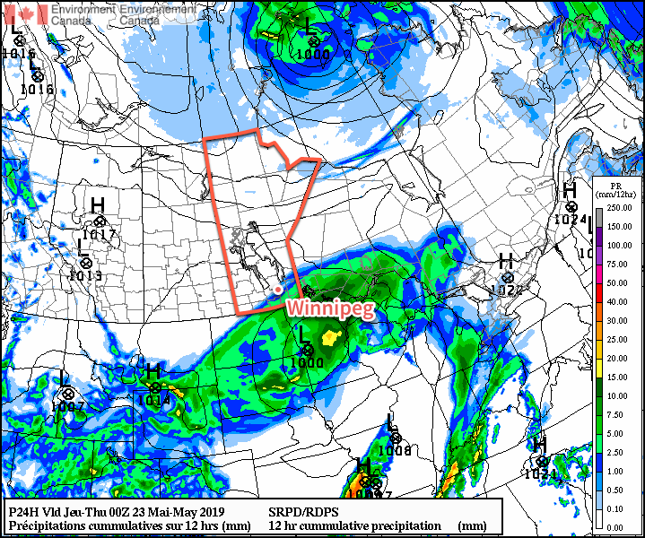
Thursday will be a gorgeous day across the region as the upper ridge begins building in. Temperatures will climb to a high near 26°C under sunny skies with light easterly winds. The wind will pick up overnight into the 20 to 30 km/h range out of the southeast as a developing low pressure system strengthens over Saskatchewan. These breezy winds will help keep temperatures warm with a low of just 16°C expected. By early Friday morning, some cloud will spread into the region along with a chance of a thunderstorm.
Very warm temperatures will move into southern Manitoba on Friday.
For Friday, a high-amplitude trough-ridge pattern over the Prairies will drive the weather. This upper flow will result in the gradual strengthening of a slow-moving low pressure system near the Saskatchewan/Manitoba border. For Winnipeg, that means a breezy southerly flow tapping into hot air mass over the northern Plains. With winds in the 30 to 40 km/h range, temperatures will climb to a high near 30°C under a mix of sun and cloud. The city may see a chance for a thunderstorm early in the day, then the chance redevelops for Friday night. Temperatures will stay warm on Friday night, dropping only to around 20°C with southerly winds continuing.
Long Range Outlook
Early indications show a rather unsettled weekend for Winnipeg. Friday’s low near the SK/MB border will stall over the province, bringing several chances for rain or thunderstorms to the city through the weekend. The weekend will start warm, but should cool towards seasonal temperatures for Sunday. Next week looks to bring settled conditions with near-seasonal temperatures.
Today’s seasonal daytime high in Winnipeg is 22°C while the seasonal overnight low is 9°C.
Summer finally arrives in Winnipeg this week with seasonal to above-seasonal temperatures in place right through the week.
An approaching low will spread heat and southerly winds of 20 to 30 km/h through the region. Much of the day will bring partly cloudy skies to the city as temperatures soar to a high near 29°C. Notably different from other warmth so far this year will be the humidity; by the afternoon, dew points will climb into the mid-teens. While it won’t feel humid per-say, it will be a noticeable difference from when temperatures reached 30°C last Thursday. The chance for thunderstorms will develop mid- to late afternoon and persist overnight as the low pressure centre approaches. Temperatures will stay warm on Tuesday night with a low near 18°C.
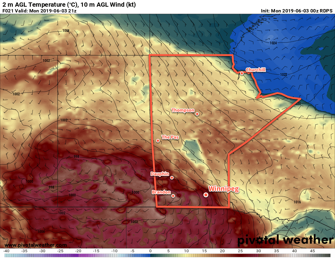
Daytime highs on Monday will climb into the upper 20s and low 30s across much of south-central and southwest Manitoba.
The low will move through the Red River Valley on Tuesday morning, bringing mixed skies northwesterly winds. By midday, the city will be under mixed to mainly sunny skies with northerly winds near 30 gusting 50 km/h. These northerly winds will clear the skies and usher in a drier air mass the afternoon. Temperatures should reach a high near 26°C midday then cool to around 21°C by the evening. Winds will ease in the evening and Winnipeg will have a pleasant night: clear skies, light winds, and a low near 12°C.
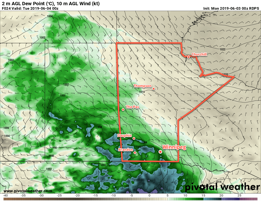
Dew points will climb into the mid-teens on Monday afternoon, bringing the first notable humdiity of the year to the region. Drier air will return through Tuesday and Wednesday.
Wednesday will see a high pressure system pass by to the south. It should keep winds light with a few clouds through the day. Temperatures will be warm again, though, with a high near 27 or 28°C. Another low pressure system moving through Saskatchewan will lift a warm front northwards through the province overnight. As it moves through, it will bring a chance of showers and/or thunderstorms to Winnipeg overnight.
Technical Thunderstorm Discussion
There is a widespread thunderstorm threat over the southeastern Prairies today. Although many ingredients are in place, the overall situation is conditional. Going over the MIST ingredients:
Moisture: Dew point values are forecast to rise into the mid-teens. There is a bit of uncertainty in this as dew points have been trending below model forecasts lately. That said, yesterday evening a pool of 15°C dew points was in place over western South Dakota. With the low-level jet continuing advection overnight, it seems likely that dew points should rise substantially towards forecasted values as the day progresses.
Instability: These dew points are forecast to produce MLCAPE values between 1000 and 1500 J/kg over SE Saskatchewan and SW Manitoba this afternoon. This instability will spread eastwards into the Red River Valley this afternoon. The instability will continue overnight with forecast MUCAPE values near 1000 J/kg spreading into the southeastern corner of the province.
Shear: Weak upper-level winds will limit shear in areas of greatest CAPE; only ~15 kt of 0-6 km bulk shear is forecast. Closer to the warm frontal boundary, strengthening upper-level winds increase the shear into the 30 to 35 kt range. Shear profiles are generally veering and would support primarily multicell thunderstorms.
Trigger: The warm front will be the primary area of focus, but strong capping will likely delay initiation until evening. Broad destabilization over southwestern Manitoba as the low approaches may trigger surface-based convection, but the storms may struggle to organize due to the lower shear values and poor ventilation aloft.
The best chance for thunderstorms looks to be over western and southwestern Manitoba this afternoon. These thunderstorms may be with the potential for some marginally severe thunderstorms. Heading into the evening, some of the activity will spread into the Red River Valley. It will likely become less extensive as the night progresses. The threat for severe thunderstorms will diminish as the night goes on.
Long Range Outlook
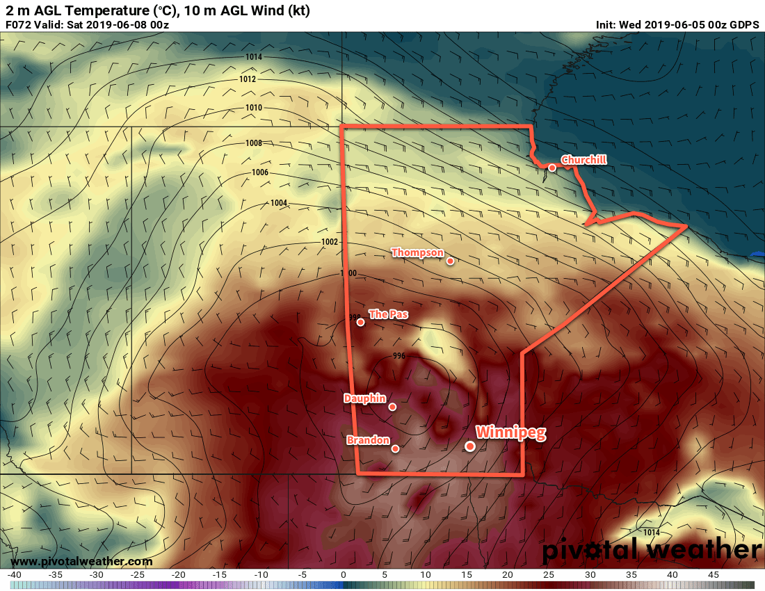
After Wednesday, Winnipeg will see the warm weather continue, but skies will be variable as several disturbances make their way through. These will bring several chances for showers or thunderstorms to the city that may persist right into the weekend. At least overnight lows will stay in the low to mid-teens and those chilly mornings will be a memory of the past by then!
Today’s seasonal daytime high in Winnipeg is 22°C while the seasonal overnight low is 9°C.
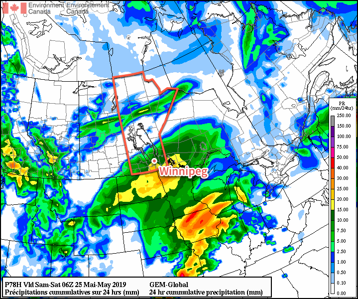
Rain will spread over Winnipeg later this morning, kicking off a weekend of unsettled conditions for the region.
More rain is on the way for Winnipeg today as another low pressure system moves through. This system shares bears resemblance to Wednesday’s rain, but will track a bit further north and is a bit stronger. Rain will spread into southern Manitoba from North Dakota through the morning. The main area of rain will exit mid- to late afternoon, but the chance for showers will continue.
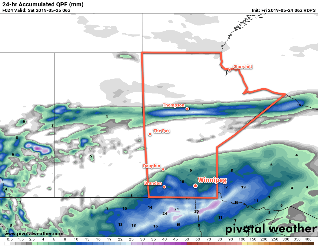
Rainfall totals for the region will be higher than seen on Wednesday. The highest amounts will fall close to the U.S. border with 15 to 25 mm by the time the rain tapers off. Rainfall amounts will diminish into the 10 to 15 mm range for Winnipeg and the Trans-Canada Highway corridor, then taper off to just a trace further north in western Manitoba across the Interlake. In Winnipeg, rain will taper off later this afternoon, but a few more showers are possible through the night. Temperatures will climb to around 14°C this morning, but once the rain moves in temperatures will dip to around 10°C. Winds will pick up out of the east into the 20 to 30 km/h range today.
Southern Manitoba will see a good soaking rain today with up to 20-25 mm of rian possible near the American border.
Winds will ease this evening with temperatures dipping to a low near 8°C overnight.
Saturday will bring mixed skies to the city. In the morning, there will likely be plenty of leftover cloud from Friday’s system, but that should break up for the afternoon. Once the sun pokes out, temperatures should manage to climb back up to a high near 19°C. The chance for showers will redevelop in Winnipeg overnight as skies cloud over and temperatures dip to a low near 8°C.
Sunday will bring more cloud and a continued chance for showers as the front stalls over the region. Temperatures should climb into the low teens with northeasterly winds up to around 20 km/h. Skies stay mostly cloudy Sunday night with another chance of showers as another disturbance crosses North Dakota. Temperatures will dip to a low around 5°C.
Long Range Outlook
The sun should reappear to kick off next week with temperatures climbing back into the upper teens and low twenties. A passing low might bring some showers to the region on Tuesday night, but otherwise it looks dry right through the end of the work week.
Today’s seasonal daytime high in Winnipeg is 21°C while the seasonal overnight low is 7°C.
Winnipeg will see two chances for rain in the second half of the work week as two disturbances move through the province over the next few days.
The first of two disturbances will impact the region today. A band of showers will push northwards out of the Dakotas this morning, reaching Winnipeg by midday. As the showers push northwards, they will also weaken, making rain more likely near the U.S. border than here in Winnipeg. The chance for showers in Winnipeg will continue through the afternoon, then taper off overnight as the low pushes eastwards. The cloudy skies and breezy northeasterly winds near 30 km/h will keep things rather cool today. Winnipeg should see a high near 13°C. Skies will clear overnight with easing winds and a low near 7°C.
Showers will graze across southern Manitoba on Wednesday.
Thursday will bring pleasant spring weather back to the region. Winnipeg will see a few cloud sand a high near 22°C. Temperatures will dip to a low near 7°C on Thursday night with increasing cloud.
The next low pressure system to impact the region will push northeastwards into North Dakota on Friday. As it does so, it will spread an area of rain into southern Manitoba. This system looks to be more organized and slightly more intense than today’s system, so it looks likely that it will bring a swath of 5 to 15 mm of rain across much of the region.
Southern Manitoba is forecast to see a more organized rainfall on Saturday.
With the cloud and rain moving through, temperatures will once be cool with a high near 15°C. The rain should move out by Friday evening, leaving behind mostly cloudy skies as temperatures dip to a low near 8°C.
Long Range Outlook
The weekend will bring variable cloudiness to the city with another chance for showers Saturday night into Sunday as a cold front slumps southwards into the region. Highs will likely approach 20°C on Saturday but drop back into the mid-teens for Sunday. After the weekend, it looks like the weather pattern will stabilize a bit, bringing more sunshine and highs near the 20°C for next week.
Today’s seasonal daytime high in Winnipeg is 21°C while the seasonal overnight low is 7°C.