Wednesday Brings Showers and Thunderstorms to the Red River Valley

Southern Manitoba will see showers and thunderstorms today as a low pressure system moves into the province.

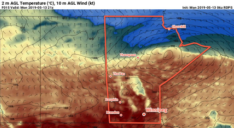
Winnipeg will see increasing cloud today as a low pressure system pushes a warm front into the province. The initial batch of showers with isolated thunderstorms will spread eastwards along a warm front into the Interlake this morning. This area of rain will likely will stay north of the Trans-Canada Highway, but there will be a small chance of scattered (thunder)showers further south through the day. With all the cloud cover over the region, highs will be seasonal despite the push of warmer air. Winnipeg should see a high near 18°C with breezy southerlies near 30 gusting 50 km/h.

The thunderstorm threat will increase this evening as a cold front begins working its way across southern Manitoba. This may end up being one of the first organized severe weather threats of the season for southern Manitoba. Going over the MIST ingredients:

  • Moisture: A southerly fetch ahead of the warm-sector trough will draw moisture northwards. Dew points will rise into the low teens along a narrow strip ahead of the trough.
  • Instability: Marginal mid-level lapes rates will limit instability despite the surge of low-level moisture. MLCAPE values will likely climb into the 500 to 1000 J/kg range by the end of the day.
  • Shear: A 60 kt jet overriding the frontal boundary will produce 50 to 65 kt of 0-6km bulk shear. While high, it’s not unreasonable for thunderstorm development.
  • Trigger: Convection will focus along a cold front as it destabilizes the low-level inversion inhibiting surface-based convection.
Most forecast models show a line of thunderstorms moving through the Red River Valley this evening as the cold front pushes through.

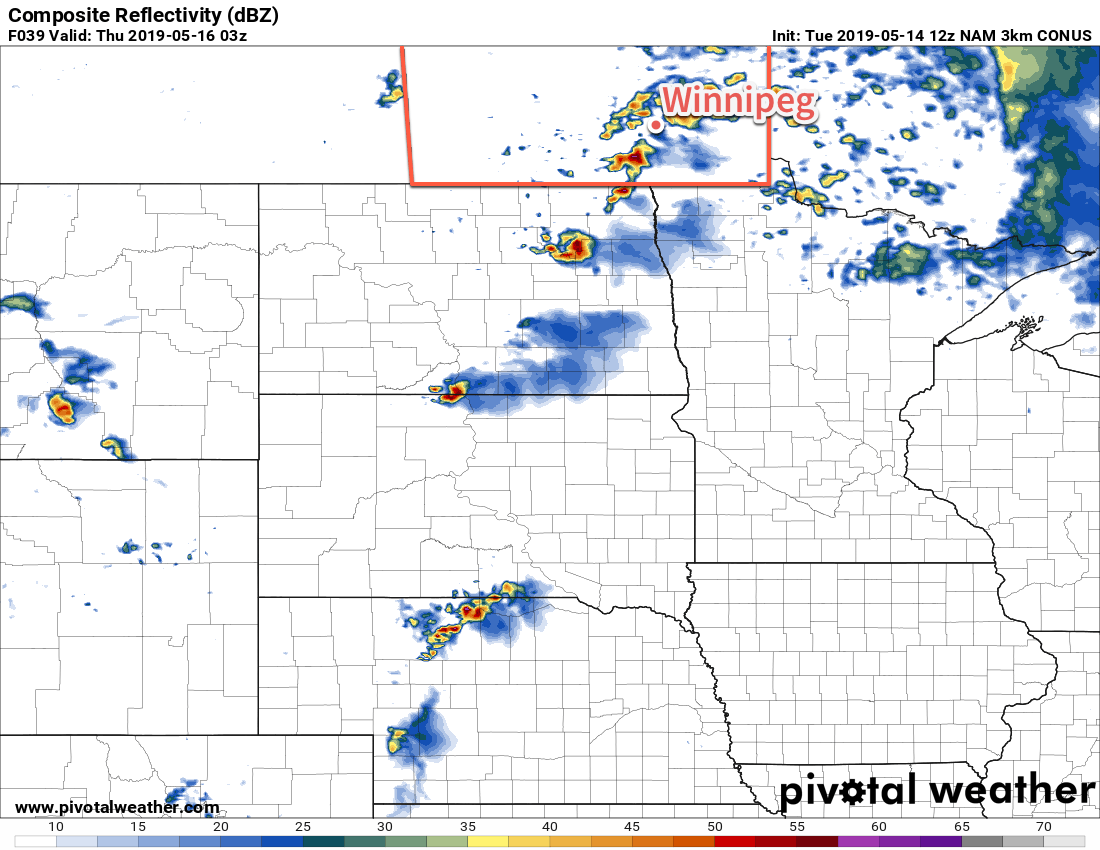
All in all, it looks like there’s a good chance of marginally severe thunderstorms developing on Wednesday evening. Strong shear will support the development of multicellular thunderstorms that may grow upscale along the front into a line of showers and thunderstorms as the evening progresses. These thunderstorms will initiate near the Saskatchewan border and then progress east-southeast across the Red River Valley through the evening. Some of these thunderstorms may become severe with primary threats being large hail and/or damaging wind gusts. The convection will clear out in the evening with breezy northwest winds of 30 gusting 50 km/h picking up behind the cold front. Temperatures will dip to a low near 7°C.

Thursday and Friday will bring variable cloudiness as a developing storm system slowly intensifies. A ridge of high pressure extending from Nunavut southwards through the province will keep things seasonably cool and dry. Tonight’s northwesterly winds will slowly taper off through the day on Thursday, with light winds expected on Friday.

Long Range Outlook

More cloud is on the way for the weekend with temperatures remaining in the mid-teens. Forecast models diverge on Sunday with American models suggesting a broad area of rain lifting northwards into southern Manitoba while the Canadian models keep things further south. With the strength of the ridging over Manitoba, I’m inclined to side with the Canadian models at this point, but we’ll certainly be keeping an eye on things to see how they develop.

Today’s seasonal daytime high in Winnipeg is 20°C while the seasonal overnight low is 5°C.

Warm And Unsettled Conditions Ahead

Several disturbances tracking across the southern Prairies will bring warm temperatures, variable cloudiness, and several chances for showers or thunderstorms.

Winnipeg will start the day with cloudy skies, but skies will clear a bit later this morning. After that, a truly summer-like day lies ahead as temperatures climb to a high near 24°C with light southerly winds. The city will see a chance of showers or thunderstorms late in the day as a cold front moves through. Skies will clear for the first half of the night as temperatures head to a low near 10°C. A low in Saskatchewan will spread cloud back into the region through the second half of the night, though.

Tuesday morning will kick off with a good chance of showers with a small chance of thunderstorms as a disturbance rolls through. After it moves through, skies should clear out fairly quickly leaving much of the day with sunny skies. Daytime highs will be cooler than today, but still pleasant at a seasonal 19°C with light winds. Temperatures will dip to a low near 6°C on Tuesday night under clear skies.

Showers with the risk of thunderstorms will move though the Red River Valley early Tuesday morning.

On Wednesday, Winnipeg will see increasing cloudiness as a low pressure system approaches from Saskatchewan. Southerly winds will strengthen to around 30 gusting 50 km/h, drawing mild air northwards. How warm it gets in the city will largely depend on how long the sun manages to shine. Around 21°C looks most likely, but if skies cloud up earlier in the day, temperatures may end up a bit cooler than that. Scattered showers and thunderstorms will develop on Wednesday evening as the low pressure system moves through. That activity will move out overnight with temperatures dropping to a low near 9°C with light winds.

Long Range Outlook

Looking ahead, it appears that southern Manitoba will be entering a rather unsettled period as a large-scale upper pattern shift occurs. The city will see numerous chances for showers or thunderstorms through the latter half of the week and the weekend. By next week, depending on how things develop, Winnipeg may see itself launch into summer with humid conditions pushing northwards into the region. While there’s some uncertainty depending on how things evolve through the weekend, it does appear that things are finally shifting gears and heading towards summer!

Today’s seasonal daytime high in Winnipeg is 19°C while the seasonal overnight low is 5°C.

Unsettled Start To Weekend Brings Warmer Weather

After an unsettled start to the weekend, Winnipeg will finally see a return to seasonal temperatures.

After a sunny start to the day, the Red River Valley will see increasing cloud cover this afternoon as a low pressure system moves into the region from Saskatchewan. Before the cloud arrives, though, temperatures should climb to a high near 15°C with southerly winds near 30 gusting 50 km/h. The chance for showers will spread into western Manitoba this afternoon and then push eastwards along a warm front draped across the southern Interlake. There will be slight chance of isolated showers south of this line in the Red River Valley, but the odds are low. Winds will veer southeasterly tonight and persist through the night in the 20 to 30 km/h range.

Any possible showers on Friday night will likely pass north of Winnipeg.

Winnipeg will continue to see mostly cloudy skies on Saturday with a better chance of showers as this system slowly heads off into Ontario. Temperatures will reach a high near 16°C with northerly winds of 20 to 30 km/h. The city may see a few sunny breaks through the day, but skies will clear in earnest on Saturday evening. Saturday night will bring light northerly winds as temperatures head to a low near 5°C.

Sunshine and warmer weather return on Sunday! With just a few clouds, Winnipeg will see temperatures climb to a high near 18°C. Winds will stay light out of the north, finally giving Winnipeg a beautiful spring day. Temperatures on Sunday night will be mild with a low near 8°C as skies become mixed.

Long Range Outlook

Next week will bring variable cloudiness with seasonal temperatures. Showers and/or thunderstorms may make an appearance sometime mid-week.

Today’s seasonal daytime high in Winnipeg is 18°C while the seasonal overnight low is +4°C.

Cool Weather Continues With Chance of Rain to End The Work Week

Below-seasonal temperatures will continue through much of the rest of the week, but a warm-up is on the way this weekend!

Today’s main weather feature will be a weak cold front will slumping south through the Red River Valley. It will bring some cloud to the region, but the sun should reappear after it moves through. Behind the front, winds will pick up out of the north to around 30 gusting 50 km/h and temperatures will top out around 12°C. Tonight should bring clearing skies with a low near the freezing mark. Winds will keep up around 20 km/h through the night.

On Thursday, the region will see sunny skies and a ridge of high pressure moves in. Winds will continue out of the north at 20 to 30 km/h and temperatures will be cool with highs near 10°C. Winds will ease in the evening as temperatures head to a low near +1°C under clear skies.

On Friday, Winnipeg will have a sunny start to the day that gives way to increasing cloudiness in the afternoon. An approaching low pressure system will strengthen southerly winds to around 30 gusting 50 km/h for the afternoon. This disturbance will spread showers through western Manitoba in the morning; these showers will likely continue to spread south-eastwards into the Red River Valley through the afternoon. Winnipeg will see the best chance for showers late in the afternoon and through the night.

Near-seasonal temperatures will finally return to the region on Friday ahead of an approaching low pressure system.

Fortunately, this system will also bring a return of closer to seasonal temperatures. Winnipeg should see a high near 16°C which is only a couple degrees below seasonal values! Skies will stay cloudy on Friday night with a chance of showers. Temperatures will dip to a low around 6°C.

Long Range Outlook

Winnipeg will finally see some warmth return this weekend. On Saturday, a slight chance of morning showers will give way to clearing and a high near 15°C. Sunnier skies are forecast for Sunday with a high near 19°C. Much of next week looks to bring near-seasonal highs in the mid- to upper-teens with variable cloudiness.

Today’s seasonal daytime high in Winnipeg is 18°C while the seasonal overnight low is +4°C.