Wet End to a Wet Long Weekend

This long weekend will end on a rainy note – big surprise! Conditions should gradually improve as we move into the work week.

image

A significant weather system will spin just to our south for the next couple days

Monday and Tuesday

Monday
image
Periods of Rain
11°C / 7°C
Tuesday
image
Periods of Rain Ending
14°C / 5°C

A powerful weather system over the Dakotas/Minnesota region will continue to bring rain to Southern Manitoba on Monday. Weather models wrap a band of rain through much of Southern Manitoba through all of Monday and even into Tuesday. Models are struggling to resolve the intensity of this rain and therefore total accumulations are a major question mark. If this band does indeed stall through Southern Manitoba for the next day and a half as models indicate, then storm total accumulations could well be in the 50 to 100mm range that models are predicting. On the other hand if things pan out differently than the models predict, which looks probable, then we’re probably looking at more like 30 to 60mm on a widespread basis (these numbers include Sunday accumulations as well by the way). I believe there is a sufficient moisture feed for those high end amounts (close to 100mm) on a localized basis. However, the intensity of rain appears to be lower than model predictions, so I think in general storm totals will be closer to the 30-60mm range mentioned above. Either way a lot of rain will be had today and tomorrow, not the way most people had hoped to spend their Victoria Day.

Wednesday

Wednesday
image
Mainly Sunny.
20°C / 5°C

Conditions should improve for Wednesday as we experience a brisk north-easterly flow behind Monday’s system. Temperatures should be in the upper teens or lower twenties.

Long Range

The late week outlook looks fairly seasonal temperature wise, with little or no additional precipitation. Long range guidance doesn’t give a clear picture of how the rest of May will play out. It doesn’t appear that we’re headed for any kind of significant cool down, but a large warm up doesn’t look likely…hopefully the long range forecast will show more clarity later this week.

Unsettled Weekend Ahead

An unsettled weekend lies ahead of us as the atmosphere slowly organizes itself into a major low pressure system to start next week.

North America Satellite Image - Annotated

North America satellite image showing the intense long-wave trough developing over the Rocky Mountains and associated convection with shortwaves pushing northeastwards into the Plains/Prairies. Orange arrows depict the jet stream.

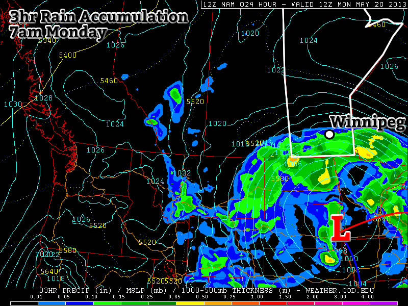
We’ll see several batches of showers/thundershowers over the next few days before a significant area of rain develops through the Dakotas may push into Southern Manitoba for the start of next week. How stormy is it going to get? Lets take a look…

Today & Tonight

Friday

20°C
A few morning showers then mainly cloudy with a chance of afternoon showers.

Today will bring mainly cloudy skies over most of Southern Manitoba ahead of a weak shortwaves ejecting northeastwards from Wyoming towards north-central North Dakota which will be coupled with a decent 500mb jet streak. There may be a few light showers over southwest Manitoba or the Red River Valley this morning as some scraps of overnight convection drift in from North Dakota, then the next slight chance of precipitation will come this afternoon.

Whether or not the afternoon convection materializes is very questionable; if it does, it would likely be driven by a phenomenon called jet coupling1 as the nose of a 70-80kt jet pushes into Southern Manitoba from Wyoming/North Dakota catches up to a weaker 40kt jet sliding across the Interlake. The most likely area for showers would be south of the lakes in the Red River Valley and west towards Brandon and the Pilot Mound area. If any showers form they’ll be relatively weak and short-lived as most convective parameters aren’t all that favourable. We’ll climb up to around 20°C today.

Friday Night

12°C
Cloudy. Showers or thunderstorms possible overnight.

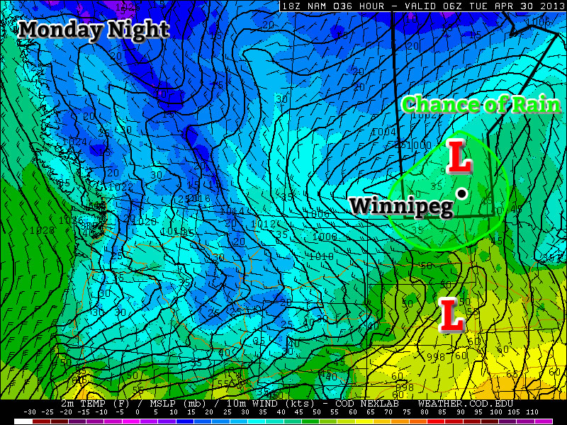
Things will begin to get more organized tonight as the first impulse pushes into Southern Manitoba. An area of showers and thundershowers should develop early in the evening through Montana and North Dakota and advect east-northeastwards into Southern Manitoba. The bulk of the system looks to track along the international border but will extend northwards towards Portage la Prairie & Winnipeg.

There’s uncertainty to exactly how far north these storms will push; the Trans-Canada corridor (including Winnipeg) may miss out on all of the precipitation or may end up seeing the bulk of it if things set up even 50-100km further north. It’s a fairly sensitive situation that we’ll be monitoring and providing updates below if necessary.

The precipitable water values are expected to rise to around 25-30mm tonight, which means that while the storms are not expected to really even approach what would be considered a severe thunderstorm, they may have the potential to produce quite a bit of rain, perhaps locally as much as 1 to 1.5” (25-35mm), in short periods of time under any heavier showers that may develop.

Saturday

Saturday

18°C / 11°C
Cloudy. Showers likely.

On Saturday we’ll likely see leftover convection pushing into the Red River Valley maintained by a weak low pushing northeastwards out of North Dakota. Whether or not this happens will depend on the low being able to initiate and support convection on it’s northern/northwest quadrant overnight, so it’s by no means a sure bet. If it does develop that convection, we’ll likely see some showers/rain in the Red River Valley through the day. Any left over precipitation will pull out of the region by Saturday evening at the latest with up to 10-15mm of rain falling through the day through the RRV and the Whiteshell. Mostly cloudy skies will remain through Southern Manitoba on Saturday night with temperatures dropping to around 10 or 11°C.

Sunday

Saturday

18°C / 11°C
Cloudy. Chance of heavy rain or thunderstorms…or not.

Sunday is a massive wildcard. What up until now has looked like a slam-dunk significant rainfall event for Southern Manitoba has been thrown into question by the latest long-range model runs which have pulled all the precipitation further south into the United States. Interestingly enough, it’s for different reasons:

  1. The GDPS2 pulls the precipitation further south due to a rather bizarre closed high it develops at 500/250mb that interacts the the long-wave trough in really, really bizarre ways. I’ve never quite seen anything like what the GDPS is doing with the upper flow and would say that I would err on the side of the past 4-5 runs which have all, definitively, placed the precipitation further north into Southern Manitoba. Importantly, the position of the main upper low has not changed with the latest GDPS run; it’s actually moved it a little east and a little further north, emphasizing the impact of the closed high it’s developing.
  2. The GFS3 is also pulling the precipitation further south, not because of bizarre acts of physics in the upper-levels, but for a rather boring reason: it’s faster and more progressive with the system. Overall it is now producing a little less precipitation than before and shifting everything further east. Instead of the deformation zone (which marks the northern/western extent of the precipitation) laying west-east through the southern Interlake region, it has the deformation zone laying along a line from Bismark, ND through Sprague, MB.

If the models are right about the rain staying to our south, then I’ll definitely believe it’s for the GFS’ reasons before I give the GDPS honours for a correct forecast. If they’re wrong, though…

If the previous runs of the models turn out to be correct, then we’d see heavy rain or thunderstorms push up into the Red River Valley on Sunday afternoon, pushing as far north as the southern Interlake by evening. The precipitation would then stall out and slowly spread east and westwards across Southern Manitoba overnight. In this scenario, it would also be likely that there would be some embedded thunderstorms on Monday night.

The Start of Next Week

…will play out in one of two ways:

  1. We’ll see heavy rain through the first day or two of the week as multiple shots of precipitation wrap across Southern Manitoba.
  2. We’ll see mainly sunny skies as the deformation zone of this system sets up through North Dakota, locking the precipitation up to our south.

It’s simply too early to tell which will come true; again, we’ll update below when things become a little more clear.


  1. When looking at jets in the atmosphere, meteorologists will look towards the left side of the nose of the jet and the right side of the tail of the jet. These regions are areas of atmospheric lift which can be very vital in forecasting convection. Jet coupling occurs when two separate jets organize in such a way that the right side of the tail of one and the left side of the nose of the other cover the same area. When this occurs, the lift can be increased substantially.
  2. GDPS stands for the Global Deterministic Prediction System; it’s Canada’s long-range forecast model.
  3. The GFS is the Global Forecast System, the US’ long-range forecast model.

Warm but Unsettled

This week will be warm, but somewhat unsettled. A fairly potent weather system will bring rain and possibly thunderstorms to Southern Manitoba on Tuesday.

image

A low pressure system will bring unsettled weather to Southern Manitoba on Tuesday

Monday

Monday
image
Showers in the morning, then becoming Mainly Sunny.
27°C / 13°C

Monday looks to be the nicest day of the week as we potentially experience our warmest day of the year so far. However, before that happens there may be some shower activity this morning along an approaching warm front. Once this front passes skies will clear and temperatures will begin to rise. High temperatures are expected to be in the mid or upper twenties, with skies becoming mainly sunny by the afternoon.

Tuesday

Tuesday
image
Mainly cloudy. Periods of Rain.
20°C / 6°C

Tuesday will be a rather unsettled day in Southern Manitoba. A strong low pressure system will bring rain and perhaps a few non-severe thunderstorms to the southern-most part of the province. The Red River Valley will be in the warm sector of this system in the morning, allowing temperatures to climb up to around the 20C mark before a cold front goes through later in the morning/early in the afternoon. There is a chance we may see some rain or a weak thunderstorm in the morning, but generally speaking the main area of precipitation is expected to pass to our north in the interlake area. Up north of Winnipeg heavy rain will be possible as a stream of moisture is lifted by this system and forms an area of rain. There may be some embedded thunderstorms within the larger area of rain, but they will not be very strong. The Red River Valley may see some wrap around rain on Tuesday night as the area of precipitation over the interlake slumps south. Precipitation amounts from this system will be nearly impossible to predict due to the potential for embedded thunderstorms. In Winnipeg we should see somewhere in the range of 5-10mm, unless a storm goes through in which case we’ll get more. North of Winnipeg upwards of 25mm is possible, but more precise estimates are too difficult to attempt.

Wednesday

Wednesday
image
Mix of Sun and Cloud
20°C / 7°C

Wednesday will see a return to more settled conditions as Tuesday’s system departs. Temperatures will be around the twenty degree mark with a breezy west wind.

Long Range

The rest of the week looks fairly seasonal temperature-wise, with perhaps a chance of light rain on Thursday and/or Friday. A first glance at the long weekend forecast reveals a chance of rain and near seasonal temperatures…but based on past experience, rain on May long weekend is usually a strong possibility…though I probably didn’t need to tell you that!

Return to Cooler Conditions

After a beautiful weekend we’ll unfortunately slip back into well below normal weather this week. This cooler weather will be triggered by the passage of a weather system on Monday.

image

A weather system will bring rain to Southern Manitoba on Monday

Today

image
Increasing clouds. Periods of rain in the afternoon-overnight.
12°C / 6°C

Today will be a fairly normal late April day. Temperatures will be in the low teens with a breezy south wind. Cloud cover will increase during the day, with there being a chance of rain beginning in the afternoon and lasting into the overnight period. This rain will be generated by a fairly strong, complex low pressure system moving through Southern Manitoba and North Dakota today. It is quite difficult to figure out what accumulations might be as the rain may end up quite showery & localized, but my guess would be around 10mm in general with locally higher amounts. The first shot of precipitation will push through in the afternoon as low-level jet over-running a weak warm front slides across the province. This precipitation will be convective in nature, meaning rainfall amounts could be fairly significant (10-20mm) in a short period of time and relatively localized. Those showers will clear out in the evening before a second batch of precipitation arrives with the main low center late overnight. Here in the Red River Valley, that means that we’ll likely see some more shower activity overnight.

Tuesday and Wednesday

Tuesday
image
Chance of Flurries.
6°C / -2°C
Wednesday
image
Mix of sun and cloud
3°C / -3°C

A cold front will swing through tonight, ushering in cooler temperatures for Tuesday. The showers tonight may transition into some flurries on Tuesday morning as this cooler air moves in. Fortunately, these flurries won’t amount to anything, but they will signal a shift back into unpleasant, below-normal conditions. On Tuesday we’ll only see high temperatures in the low single digits with similarly cool values on Wednesday.

Long Range

In the long range there is no sign of a shift towards a more consistently above normal pattern. It looks like we’ll see near normal conditions return around the weekend, with some days being a bit below normal, with others are slightly above normal. There is also no sign of significant precipitation in the long range, which is a good for the flood situation.