After a beautiful weekend we’ll unfortunately slip back into well below normal weather this week. This cooler weather will be triggered by the passage of a weather system on Monday.
Today
Increasing clouds. Periods of rain in the afternoon-overnight.
12°C / 6°C
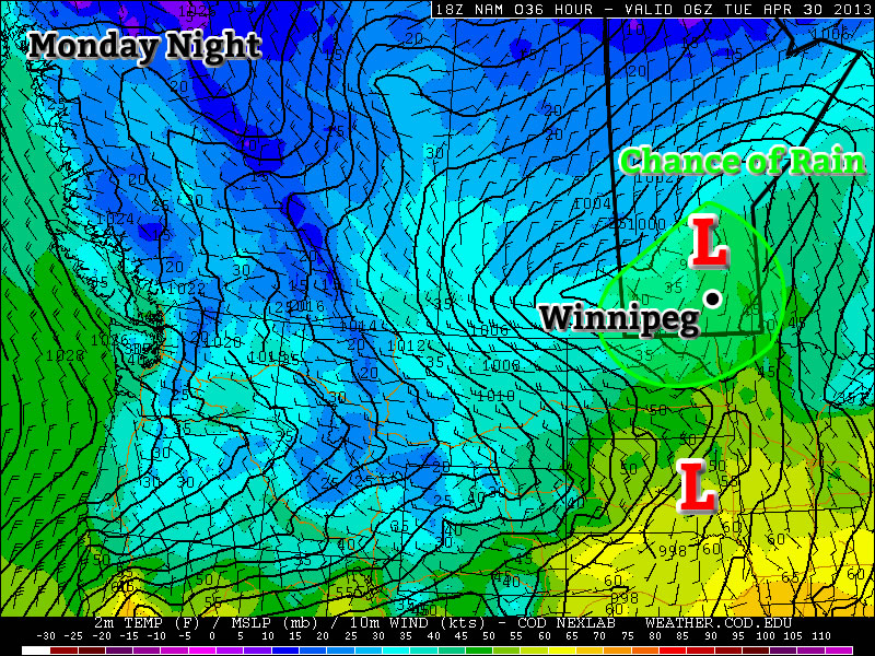
Today will be a fairly normal late April day. Temperatures will be in the low teens with a breezy south wind. Cloud cover will increase during the day, with there being a chance of rain beginning in the afternoon and lasting into the overnight period. This rain will be generated by a fairly strong, complex low pressure system moving through Southern Manitoba and North Dakota today. It is quite difficult to figure out what accumulations might be as the rain may end up quite showery & localized, but my guess would be around 10mm in general with locally higher amounts. The first shot of precipitation will push through in the afternoon as low-level jet over-running a weak warm front slides across the province. This precipitation will be convective in nature, meaning rainfall amounts could be fairly significant (10-20mm) in a short period of time and relatively localized. Those showers will clear out in the evening before a second batch of precipitation arrives with the main low center late overnight. Here in the Red River Valley, that means that we’ll likely see some more shower activity overnight.
Tuesday and Wednesday
Chance of Flurries.
6°C / -2°C
Mix of sun and cloud
3°C / -3°C
A cold front will swing through tonight, ushering in cooler temperatures for Tuesday. The showers tonight may transition into some flurries on Tuesday morning as this cooler air moves in. Fortunately, these flurries won’t amount to anything, but they will signal a shift back into unpleasant, below-normal conditions. On Tuesday we’ll only see high temperatures in the low single digits with similarly cool values on Wednesday.
Long Range
In the long range there is no sign of a shift towards a more consistently above normal pattern. It looks like we’ll see near normal conditions return around the weekend, with some days being a bit below normal, with others are slightly above normal. There is also no sign of significant precipitation in the long range, which is a good for the flood situation.