Unsettled March Weather Continues

Southern Manitoba played host to almost all the different kinds of weather out there, with many locations seeing almost any combination of thunderstorms, hail, rain, drizzle, snow and blowing snow. A system that brought heavy snowfall to Western Manitoba and the Interlake region as well as thunderstorms and rain to the Red River Valley and Southeast Manitoba has trundled off into Ontario; we’re not out of the woods yet, though, as another system is set to quickly make it’s way into the province by tomorrow morning.

Hail Accumulation

Photo of accumulated small hail at a downspout exit. Winnipeg was hit with hail from this size up to as large as dimes as a thunderstorm pushed through the city at around 2:30AM on Tuesday morning.

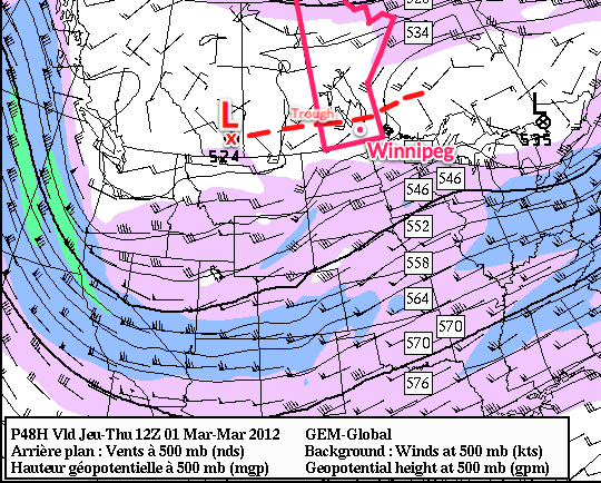
For today, we’ll see cloudy skies with a chance of a few remnant flurries this morning. We’ll see a daytime highs of only 2°C or 3°C through the RRV. Another low pressure system is already on it’s way to Manitoba, however, with the parent upper trough making landfall on the Oregon coast last night. This trough will advect eastwards and rotate northwards into the Central Prairies, bringing with it a warm front that will bisect the Prairies and slowly push eastwards.

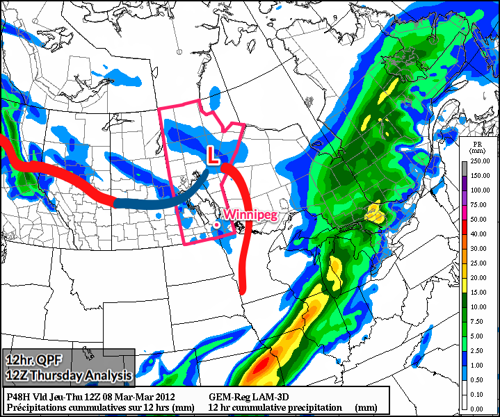
This warm front is expected to push through the Winnipeg and the Red River Valley through the day on Thursday. Current indications are that we’ll be far enough south that we won’t have to worry about snow, that should be reserved for areas a bit further north in the Interlake region. We’ll see rain push in tomorrow morning around mid-morning and clear out by early evening. Rainfall totals currently look to be fairly uniform through the Red River Valley with totals around 10-15mm, however it does look like there’s a good chance for some enhanced convective areas which will result in fairly heavy showers interspersed through the general area of rain.We’ll enjoy warmer temperatures through the rest of the week, with the warm air pushing through bringing our daytime highs up to around 10°C.

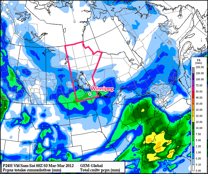
We’re not out of the woods quite yet, though, as another low is forecast to track through the southern Interlake region bringing rain to areas along and north of the Trans-Canada Highway Friday night and Saturday morning. Current indications are that regions south of the Trans-Canada Highway will only see some scattered showers with this system.

8-14 Day Temperature Anomaly Outlook

NAEFS 8-14 Day Temperature Anomaly Outlook, valid for April 4 – April 11.

With a the passage of Tuesday’s weather system, North America has transitioned into a much different weather pattern that that which brought us our record-busting heat wave. With the blocking high collapsed over the SE United States, the summer-like heat will be contained further south in the Central and Southern Plains of the United States. Fortunately, the bitterly cold Arctic air that’s still omnipresent north of 60 will remain bottled up. So what does that mean for us? As the image above shows, ensemble forecasts are showing a moderate chance of above normal temperatures, however nothing nearly as certain as what was being predicted a couple weeks ago. The long-wave pattern has shifted to favor more frequent disturbances tracking through the Prairies, which should result in temperatures that may still be slightly above normal, but we’ll likely also see more precipitation than we had through much of March.

Spring at the Gates

After the blast of winter Winnipeg and the rest of Southern Manitoba recieved last week where some regions recieved upwards of 7” of snow, spring has begun its march towards Southern Manitoba. After a cooler day today, we’ll see temperatures climb into the low single digits for the rest of the week. Some weather models show suprising heat building into the province, so the big question is: just how warm is it going to get?

12hr. QPF w/Surface Analysis

GEM-REG model image valid 12Z Thursday morning. Shaded areas are 12hr. precipitation accumulation. Red lines represent warm fronts and dark blue lines represent the cold front.

Southern Manitoba will start today on the cold side of a baroclinic zone that carves across Central Saskatchewan into North Dakota. This will limit our temperatures into the low minus single digits with daytime highs through the Red River Valley reaching only -7 or -8°C with a light northwest wind.

Winds will veer to the southwest in the evening as a low pressure system track through the Central Prairies drags a warm front across Southern Manitoba. This front will have a few scattered flurries associated with it, but accumulations should be only from a skiff to a cm. After the front passes overnight, temperatures will be on the up and up for the forseeable future.

On Thursday, we should see temperatures climb to around -4°C through the RRV under sunny skies. Thursday night temperatures will drop to between -15 and -20°C on the last cold night for a while. On Friday, temperatures will climb above zero and stay there through the night as temperatures are sustained by a southerly wind supplied by a powerful low pressure system tracking along the 60th parallel. Warm temperatures combined with a south-east wind will likely result in fairly cloudy skies as moisture from the melting snow is trapped underneath all the warm air aloft.

In the long term, models continue to pump warm air over Southern Manitoba. Warm temperatures will be the name of the game as low after low tracks across the northern Prairies. Little precipitation is in the forecast over the next 10 days, and the real question is just how warm will it get? High temperatures will be highly dependent on snow cover and, thus, difficult to accurately forecast. We’ll have to see just exactly how quickly the snow cover is eroded to get a better handle on high temperatures next week.

When a substantial snowpack is in place, daytime temperatures can have extreme difficulty rising much above 0°C regardless of the temperatures even a couple hundred feet off the ground. In Winnipeg, temperatures will often top out at 2 or 3°C under light or southerly winds. Under a westerly or south-west wind, temperatures can reach as high as 6 or 7°C, even with a snowpack.

The GFS currently has all the snow melting over the RRV by the middle of next week, and subsequently is able to pump up daytime highs as high as 16°C. This seems somewhat unrealistic, given how the snowpack was substantially reinforced at the end of last week.

Snow Tapering Off Today

Today’s post will be short as I’m occupied with some family-related business.

Moderate snow pushed into the Red River Valley yesterday evening, bringing reduced visibilities and slippery conditions. Snow will continue through much of the day before tapering off.

Accumulated Precipitation From 00Z Friday to 00Z Saturday

GEM-GLB Accumulated precipitation from 00Z Friday to 00Z Saturday

Snowfall accumulations will generally be close to 5cm, however there will be a swath near the Trans-Canada highway between Brandon and Winnipeg that will likely see total amounts in the 5-10cm range. Snow should taper off by evening, and we’ll see an overnight lows throughout the RRV around -15°C.

Over the weekend, we’ll see mostly sunny skies with daytime highs near between -10° and -5°C, with overnight lows between -20°C and -15°C. The next chance for precipitation will come Monday with a passage of a warm front that will push our temperature up into the plus mid-single digits.

Unsettled Weather into the Weekend

After a few sunny days, snowier weather will return to Southern Manitoba as a slow-moving system tracks from Southern Saskatchewan into Southern Manitoba along the international border. For today, we’ll see skies cloud over this morning, but we’ll still have beautiful conditions, with highs through the entire RRV sitting within a degree or two of 0°C and winds dying off by early afternoon.

Tonight will mark a transformation to a snowier pattern, however, as a complicated series of shortwaves begin to march across the Prairies associated with a strong upper low.

500mb Winds

500mb Winds from the GEM-REG valid 12Z Thursday morning, March 1st.

As the Colorado low that has brought severe winter weather to the Northern Plains progresses eastwards, an upper low will be pushing into Southern Alberta and inducing troughing eastwards across the Southern Prairies. As this troughing occurs, a series of smaller shortwaves will lift northwards and track across Southern Manitoba.

Tonight, an area of light snow will develop along the RRV in North Dakota and slowly lift northwards into Winnipeg. This area of snow will slowly fizzle out over the region before being replaced by a more organized area of snow that will push across Southern Manitoba as the main low tracks across the Southern Prairies. By Thursday night, we’ll be back under steady snowfall.

24hr. QPF

24hr. Precipitation Accumulation valid 12Z Friday morning, March 2nd.

The entire system will exit the region overnight on Friday. Snowfall totals west of the Trans-Canada highway will be general amounts near 5cm. Areas in the RRV and east into the Whiteshell will see more, with widespread accumulations of 5-10cm and localized amounts potentially reaching as high as 12-13cm. These amounts are estimates right now, and we’ll certainly see how things shape up over the next day and a bit.

After this system clears out we’ll have a bit of an unsettled weekend with the potential for some light flurries as a weak low pressure system tracks through Central Manitoba. The next potential for snow comes on Monday as another powerful low pressure system tracks through the Prairies. More on that on the weekend!