Light Snow Gives Way to Cool But Pleasant Conditions

Snow moving through the region today will give way to more sunshine, but below-seasonal temperatures remain.

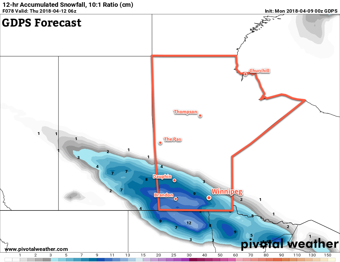
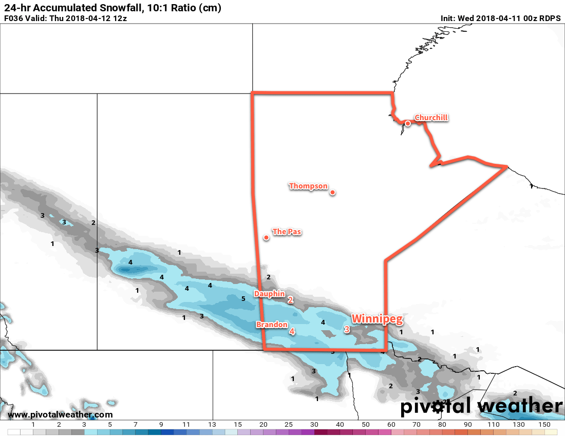
Winnipeg will see another day with high temperatures above the freezing mark with cloud cover spreads eastwards into the Red River Valley. Winds will remain light, which should help make a relatively pleasant day. Skies in Winnipeg will become cloudy by late afternoon with light snow spreading into the region this evening. This system will bring 2 to 4 cm of snow to the city1, but higher amounts will fall to the west and southwest. 4 to 8 cm of snow is likely through Parkland and southwestern Manitoba, extending into the southwestern Red River Valley. The snow will ease to a few flurries overnight as temperatures dip to a low near -6°C.

24hr. RDPS Snow Accumulation (at 10:1 SLR) valid 12Z Thursday April 12, 2018
A swath of snow will fall across southwestern and south-central Manitoba Wednesday afternoon into Wednesday evening.

Any remaining flurries will taper off on Thursday morning as skies gradually clear. Temperatures will be similar to Wednesday with a high near +1°C, but northerly winds of 15 to 25 km/h will be more prominent in the afternoon. While Winnipeg will have more sun than cloud by the afternoon, the southern Red River Valley will likely have to wait until evening to see the cloud cover move out. Winds remain out of the north at 10 to 20 km/h on Thursday night as temperatures dip to a low near -11°C.

Friday will bring mainly sunny skies to Winnipeg as a ridge of high pressure builds in from the north. Winds will continue out of the north at 20 to 30 km/h. Temperatures will continue to be cool with a high near +1°C. Winds will ease on Friday night as temperatures dip to a low near -12°C.2

Long Range Outlook

The weekend is actually looking quite pleasant with plenty of sunshine and daytime highs climbing back into the mid-single digits.3 Winds look to remain light out of the east.

The next chance for precipitation looks to come mid-week with increasing cloud as a Colorado Low develops over the Northern Plains. On the bright side, it looks like a gradual trend towards seasonal temperatures through the course of the week!

Winnipeg’s seasonal daytime high is currently 9°C while the seasonal overnight low is -3°C.

  1. Amounts could end up a bit less due to snow melting on contact with the ground early in the event.
  2. With the incoming ridge of high pressure, it’s possible that temperatures could reach even a few degrees colder if the conditions are right.
  3. It has to be noted, though that this is still well below seasonal normals.

Temperatures Climb Above Freezing But More Snow Ahead

Temperatures will finally climb above 0°C this week, but sadly more snow is on the way.

Winnipeg will see temperatures finally climb above the freezing mark today as the high climbs to around 0 or +1°C under sunny skies. Once the sun burns off the morning chill, it will actually be a fairly nice day with light winds as a ridge of high pressure moves across the province. A bit of cloud cover will begin moving into the region tonight as temperatures dip to a low near -7°C.

Tuesday will bring mixed to mostly cloudy skies as thicker cloud cover builds into the province ahead of the next low tracking across the Prairies. Temperatures will reach the closest to seasonal they’ve been since March 28th with a high near +4°C expected. Unfortunately, this will still be a fair amount below the seasonal high of 8°C. Winds will pick up out of the west to around 15 to 25 km/h in the afternoon. Skies will become overcast Tuesday evening with temperatures falling to a low near -4°C.

12hr. Accumulated Snowfall GDPS/GFS/NAM Comparison valid 00/06Z Thursday April 12, 2018
Comparisons of 12 hour accumulated snowfall across Southern Manitoba through the day Friday

A weak low passing through Saskatchewan into North Dakota will spread a narrow swath of snow southeastwards across the Canadian Prairies. It will spread snow across Manitoba through Wednesday, however where the snow exactly falls is a bit in question and depends precisely on the track the low ends up tacking. In general, it looks like this low will produce a swath of snow from western Manitoba into North Dakota. Around 5 to 10 cm of snow looks likely along the centre of the swath with amounts quickly tapering off into the 2 to 4 cm range to the north and south. Isolated pockets of higher amounts are possible under the heaviest band.

Winnipeg will likely end up under or just north of this band. It looks like 2 cm would be a likely low-end forecast for Winnipeg, with 3 to 6 cm looking likely through the day. That said, with temperatures near or just above freezing, some of that snow may melt, shaving a bit off the measurements.

The snow will taper off in the afternoon/evening, with winds picking up out of the north-northeast to around 20 to 30 km/h. Temperatures will head to a low near -6°C under cloudy skies on Wednesday night.

Long Range Outlook

Attention then turns to Friday, where weather models are picking up on the development of a potent storm in the United States but have strongly diverging opinions on where it will go. There may be a good chance that it remains south of the border as a strong deformation zone develops south of the 49th as the cooler outflow from the northern Prairies is pinned against the developing Wyoming/Colorado low.

GDPS 24hr. Snowfall Accumulation Forecast valid 00Z Saturday April 14, 2018
While the location is uncertain, there is good agreement of Friday’s storm system producing upwards of 25 cm of snow along its heaviest swath

Earlier model runs had this system pushing into southern Manitoba, which is something we’ll definitely keep an eye on. It will be a very potent storm, likely producing significant snowfall with totals of more than 25 cm across its heaviest bands, so wherever it ends up will have to deal with a return of treacherous winter travel conditions. We’ll be keeping an eye on things as they develop and have updates later in the week!

Winnipeg’s seasonal daytime high is currently 8°C while the seasonal overnight low is -3°C.

Cool Weather Continues

The rest of the week will bring more of the same: unseasonably cold temperatures.

Cold weather will continue for Winnipeg throughout the second half of the week as a persistent northwesterly continues to tap into Arctic air. Daytime highs will remain well below the seasonal value near 6°C over the coming days starting with a high near -2°C today that will slump towards -5°C by Friday. Overnight lows will keep with the trend as well, generally hovering near -15°C, about 10°C below seasonal.

Skies will be cloudier through the second half of the week than they were in the first. A sunny start to today will lead to mixed skies this afternoon as low-level instability develops. These clouds will dissipate as soon as the temperatures begins dropping in the evening. Quickly replacing them will be a more organized area of cloud associated with a weak low pressure system tracking across northern Montana into North Dakota. This will spread mostly cloudy skies into Winnipeg and the Red River Valley for Thursday. An area of organized light snow will likely spread eastwards through areas primarily south of the Trans-Canada Highway on Thursday morning, but flurries are possible for much of the day as another cold front slump southwards through the province. Skies will be back to mixed to mainly cloudy on Friday with a very slight chance of a flurry.

GDPS 300mb Height and Wind valid 12Z Thursday April 5, 2018
An entrenched and slow-moving vortex over southern Hudson Bay is sustaining a cold northwesterly flow over the Canadian Prairies

The wind won’t be too much of an issue today, but on Thursday they’ll pick up out of the northwest again up to 30 km/h. The winds will ease on Thursday night, then pick back up to 30 gusting 50 km/h on Friday. Brrr!

Long Range Outlook

The extended forecast hasn’t changed too much from our last forecast: a slow and gradual trend towards seasonal conditions. That said, what is considered seasonal is changing quickly now; the seasonal daytime high is increasing by 0.4°C per day right now, so today’s 6°C will be nearly 9°C by this time next week. That said, it is beginning to look like temperatures may return to seasonal values by the latter half of next week, so relatively speaking, a big warm-up might be in store next week!

Winnipeg’s seasonal daytime high is currently 6°C while the seasonal overnight low is -5°C.

Variable Cloudiness, Cool Temperatures, And A Chance of Flurries

Winnipeg will see variable cloudiness over the next few days with a couple chances for flurries. Below seasonal temperatures will continue as well, with little improvement expected until next week.

Winnipeg’s chilly morning will lead to a cool day with a daytime high of just -10°C, a whopping 15°C below seasonal for this time of year. The city will see a sunny start to the day, but cloud cover will build in from the west this afternoon associated with a low pressure system moving into Montana and North Dakota. As the cloud moves in, the city will see a slight chance of flurries, but the better chance for snow will be in the southwestern Red River Valley westwards to the Saskatchewan border. Skies will clear tonight with temperatures dipping back down to around -19°C again.

Saturday will bring more cool weather to the region with daytime highs once again near -10°C with gusty northwesterly winds of 30 to 40 km/h developing in the afternoon. Mainly sunny skies in the morning will give way to mixed to cloudy skies in the afternoon as cloud cover drifts southwards out of northern Manitoba. This cloud will bring a good chance of flurries with it. The cloud and chance for flurries will persist into the evening. Temperatures will drop to a low near -13°C on Saturday night with skies becoming mixed towards morning.

RDPS 12hr. QPF valid 00Z Sunday April 1, 2018
Much of Manitoba will see light snow or flurries on Saturday

Sunday looks to bring warmer temperatures to the region. The high temperature for Winnipeg should end up near -4°C: still below seasonal, but better than the days before it. Winds will be westerly at 20 to 30 km/h with mixed skies. Those mixed skies look like they’ll stick around Sunday night as temperatures dip to a low near -13°C.

Long Range Outlook

Next week looks like it will bring benign weather to Winnipeg with temperatures gradually climbing back towards seasonal by next weekend. No significant precipitation is expected through the week, although a few flurries may roll through a few times.

Winnipeg’s seasonal daytime high is currently 5°C while the seasonal overnight low is -6°C.