The cool weather will continue through the next few days with daytime highs struggling near 5°C below seasonal for early April. Heading into the weekend, the wind will be the biggest story as a low pressure system brings strong southerly winds to the region on Saturday and strong northerly winds on Sunday.
A ridge of high pressure situated over the province will bring cool temperatures, clear skies and light winds to Southern Manitoba today. In Winnipeg & the Red River Valley, temperatures will climb to a high near -4°C, some 12°C below seasonal values for this time of year. Tonight will be a cool night with overnight lows dipping below -10°C. Through the second half of the night, cloud cover ahead of an approaching low pressure system will begin spilling into Western Manitoba and towards the Red River Valley.
Windy Saturday
Saturday’s weather will be dominated by a fairly strong low pressure system moving across the province. The primary story for Winnipeg & the Red River Valley will be the strong winds associated with it.
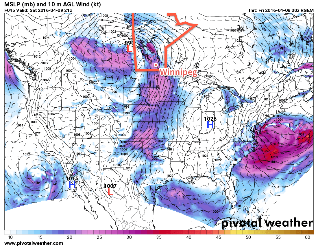
Beginning mid-day on Saturday, strong southerly winds will develop over the Red River Valley southwards into the Dakotas. Winds will reach their peak by mid-afternoon with sustained winds of 50-60km/h with gusts up to 80km/h. The winds will then diminish in the evening as the low pressure centre moves over the region.
There will be a chance of some shower or flurry activity with this system on Saturday, but at this point it looks like a vast majority of the precipitation will remain to the north, primarily falling through Parkland Manitoba eastwards through the Interlake.
Temperatures will climb to around +2°C during the day under mainly cloudy skies.
Flurries Move in on Saturday Night Alongside Strong Northerlies
With the passage of the low occurring mainly on Saturday night, temperatures will remain relatively warm; by early Sunday morning the temperature is expected to dip to just -2°C. It will begin to feel a lot colder, however, as the low passes to the east and strong northwesterly winds begin moving in behind the system.
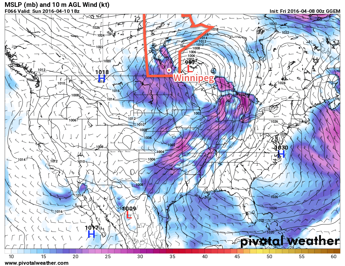
Sunday will be another cloudy day with decent chance of some flurry or light snow activity as temperatures climb to a high of +1°C. Winds will strengthen out of the northwest to 40-50km/h with gusts up to 60km/h. The wind ease to 30km/h or so on Sunday night as temperatures dip to -8°C for a low.
Long Range: Heading Into A Warming Trend
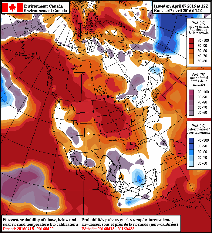
After a lengthy stretch of below-normal temperatures, it’s beginning to look like we’ll finally see a taste of spring in the second half of next week as an upper-level ridge begins shifting eastwards and spreading milder air into Manitoba. Daytime highs of will climb towards 10°C by the end of next week. No significant precipitation is expected through the next 4-8 days at the moment.
Winnipeg’s seasonal daytime high is currently 8°C while the seasonal overnight low is -4°C.