Mild Weekend Ahead With A Windy End

A series of low pressure systems moving through Manitoba will bring mild temperatures back to the region for the weekend.

Winnipeg will see temperatures climb back towards the freezing mark this weekend as milder Pacific air builds into the region. This warmth will come in two waves, each tied to a low pressure system moving through the province. The first low will move into northern Manitoba today and spread seasonal temperatures back into southern Manitoba. With skies becoming mixed today, Winnipeg will see a high near -6°C today. Winds will be light through the morning hours, then pick up into the 20 to 30 km/h range for the afternoon and evening.

Skies will cloud over for the night with temperatures hovering around -5°C. Winds will gradually ease through the night.

On Saturday, a second low pressure system will begin to move towards the province from Saskatchewan, pushing warmer conditions towards the region. The city will see mostly cloudy skies, but temperatures will climb to a high near 0°C with light southerly winds. It will cool only a bit on Saturday night with a low near -3°C.

GDPS 10m Wind Forecast valid 18Z Sunday March 1, 2020
Moderate west-northwest winds will develop across southern Manitoba on Sunday.

The low will move across Manitoba on Sunday, sweeping a cold front across the region through the morning. Temperatures will stay seasonably mild with a high near -1°C, but moderate west-northwest winds of 40 to 50 km/h will develop behind the front. Skies will continue to be mostly cloudy and there will be a chance for some flurries as front moves through and cooler air pushes into the region. Temperatures will begin to head back towards seasonal values on Sunday night with a low near -12°C under clearing skies. The winds will taper off through the evening hours.

Long Range Outlook

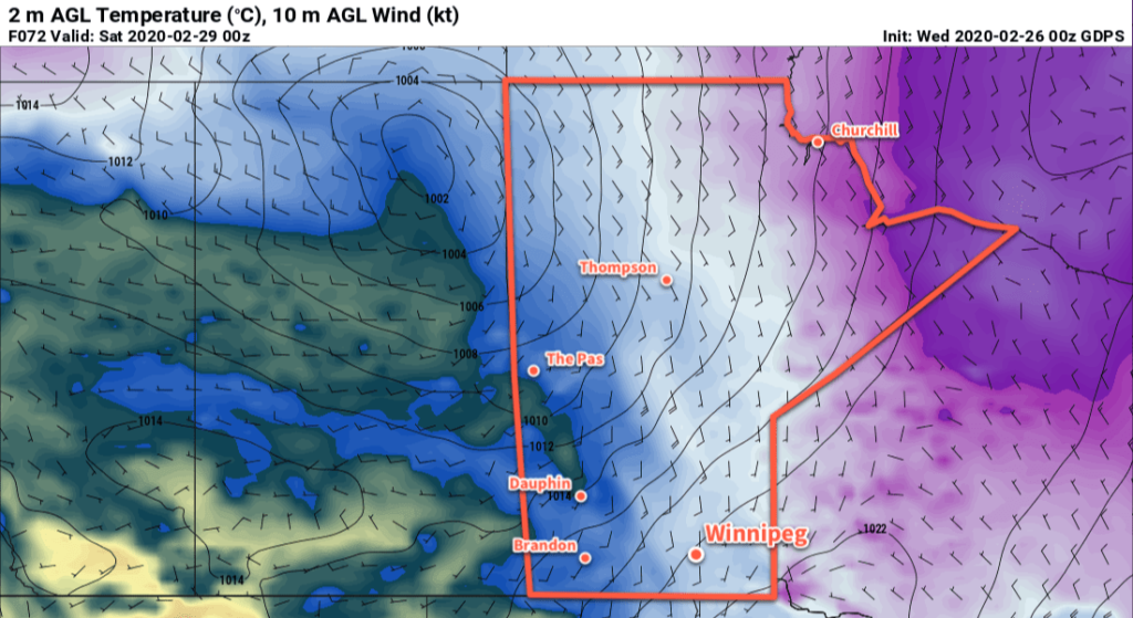
Warm weather looks to continue into the beginning of next week as Pacific air continues to flow over the Prairies. There will be a couple stronger low pressure systems moving through the province in the first half of the week. The first will likely keep well to the north of Winnipeg and mainly impact central and northern Manitoba. The second, however, may swing through further south and bring a notable snowfall to southern Manitoba Tuesday night into Wednesday.

That said, there is still significant disagreement among the forecast models as to how this next series of lows will evolve, so for now we’ll sit tight, enjoy the warm weather, and take another look at things at the start of the new week!

Today’s seasonal daytime high in Winnipeg is -6°C while the seasonal overnight low is -16°C.

Plenty of Cloud With Seasonably Cool Conditions

Winnipeg will see plenty of cloud over the coming days as a weak Arctic high slides through the province. Temperatures will return to seasonal values by the end of the week, followed by a return to mild temperatures for the weekend!

Winnipeg should see ample low cloud today trapped under an Arctic ridge moving across the province. The city should see a high near -12°C, which is favourable for the chance of a few non-accumulating flurries. Winds will be light through the day. The region may see some sunny breaks, particularly through the afternoon hours. Temperatures will dip back down to a low near -18°C tonight with mixed to cloudy skies.

On Thursday, winds will be light out of the southeast as the ridge slowly exits the province. Temperatures will be a bit warmer with a high near -9°C as the region sees cloudy skies with periods of light snow. The snow won’t pile up to anything too significant, but 1 to 2 cm by the end of the day may be enough to get the roads nice and slick again. The city will see mixed to cloudy skies on Thursday night with a low near -15°C.

GDPS 2m Temperature Forecast Valid 00Z Saturday February 29, 2020
Warmer temperatures from the west will begin to move into Manitoba on Friday.

Temperatures will climb a tad more on Friday to a high near -8°C in Winnipeg with mostly cloudy skies. Winds will be light through the morning, then pick up into the 20 to 30 km/h range by the end of the afternoon. There’s a chance for some more light snow on Friday evening as a warm front pushes through, but most of the snow should stay north of the city. Winds will shift to the west overnight with mixed skies. Temperatures will rise to around -5°C by Saturday morning.

Long Range Outlook

Warm weather returns to Winnipeg for the weekend with highs near 0°C and variable cloudiness. Breezy conditions will develop on Sunday into Monday with a chance for some light snow later in the day on Sunday through the night as a low crosses the province.

Mild temperatures are forecast to continue through the first half of next week before returning to seasonal values.

Today’s seasonal daytime high in Winnipeg is -6°C while the seasonal overnight low is -16°C.

A Return to More Seasonal Conditions

After a sunny and mild weekend, temperatures in Winnipeg will gradually dip back towards seasonal values.

Cooler temperatures will gradually return to Winnipeg this week as the westerly flow aloft that brought mild Pacific air to the Prairies slowly collapses. As the flow aloft turns northwesterly, a weak ridge of high pressure will build southwards out of the Arctic and through Manitoba.

GDPS 2m Temperature Forecast valid 18Z Wednesday February 26, 2020
Cooler temperatures will return to Winnipeg mid-week.

As the high builds in, the region will see variable cloudiness as temperatures head to slightly below-seasonal values. Highs will fall from near -2°C today to -12°C by Wednesday with overnight lows dipping into the -20s midweek. A few flurries will be possible Monday night into Tuesday as the cooler temperatures push into the region.

Winds will be generally light over the coming days. Tuesday will bring comparatively breezy conditions with northwest winds of 20 to 30 km/h. Monday and Wednesday, on the other hand, will see northerly winds up to 15 km/h.

Long Range Outlook

The cooler conditions will be short lived as an upper ridge quickly begins building back into the region. Temperatures will gradually warm through the second half of the week with highs likely reaching back to the 0°C mark by Saturday. The mild weather will persist into next week. No notable snowfall is in the forecast.

Today’s seasonal daytime high in Winnipeg is -6°C while the seasonal overnight low is -17°C.

Sunny, Warm Weekend Ahead

Winnipeggers will get a break from the cold this weekend as a mild Pacific air mass brings warmer temperatures to the region for the weekend.

Winnipeg has seen temperatures climb from below -20°C on Thursday morning into the mid-minus single digits this morning. Temperatures will continue to climb today as westerly winds continue to spread mild Pacific air eastwards. Under sunny skies, Winnipeg will see a high near -2°C with west winds around 20 km/h. Skies will stay clear tonight as temperatures head to a. Low near -8.

The city will continue to see mainly sunny skies on Saturday with temperatures reaching a high near 0°C. Winds will be out of the southwest at 10 to 20 km/h. A bit of cloud cover will move in on Saturday night with temperatures dropping to a low near -7°C.

RDPS 2m Temperature Forecast valid 21Z Saturday February 22, 2019
Mild weather will be in place over southern Manitoba through the weekend.

On Sunday, a weak cold front will sweep through the region in the morning. Behind the front, breezy northwest winds will develop up to 30 gusting 50 km/h. Temperatures will be mostly unaffected by this, however, with a high once again near 0°C. The city will see partly cloudy to mixed skies through the day. Sunday night will see the winds easing off as temperatures dip to a low near -10°C.

Long Range Outlook

Seasonably mild conditions will stick around for Monday, then a cold front will push through and gradually send temperatures back to seasonal to slightly below-seasonal values midweek. Milder weather should return next weekend.

Today’s seasonal daytime high in Winnipeg is -7°C while the seasonal overnight low is 17°C.