Mild Weather Continues Through The Week

Mild weather will continue through the remainder of the week with daytime highs generally 3-6°C above normal for the latter half of February. With limited snow and some sunshine expected, it’s shaping up to be a fairly pleasant few days.

Cloudy skies will be in place over the Red River Valley today as a weak low pressure system slides across the region. Alongside the cloud will be some light flurry activity that’s just enough to be noticeable, but hardly enough to actually leave much of a mark. Winds will be fairly light out of the north-northwest at just 10-15 km/h with temperatures climbing to a high of -2°C. Skies will clear overnight as a weak cold front slumps through Southern Manitoba; temperatures will dip down to around the -11°C mark for the overnight low.

Thursday will be a slightly cooler day as a weak ridge of high pressure moves through the province behind Wednesday’s cold front. It will be a pleasant day, though, with a high temperature near -7°C, light winds and partly cloudy skies. Clouds will thicken up over the Red River Valley by Thursday night as a low pressure system approaches from the northwest.

GDPS Surface Temperature Forecast valid 00Z Saturday February 27, 2016
The GDPS is forecasting near-0°C temperatures for Southern Manitoba on Friday.

Friday’s weather will be very mild as a low pressure system crossing central Manitoba spreads mild air eastwards over the southern half of the province. Westerly winds of 15-25 km/h will push temperatures up to the -2 to 0°C range here in the Red River Valley. Skies will be mainly cloudy with no precipitation expected through the day. A cold front will slump through the region on Friday evening, bringing some scattered flurries and cooler temperatures. Overnight winds will shift out of the north to 20-30 km/h and temperatures will dip to about -9°C by Saturday morning.

Long Range: Cooler & Unsettled

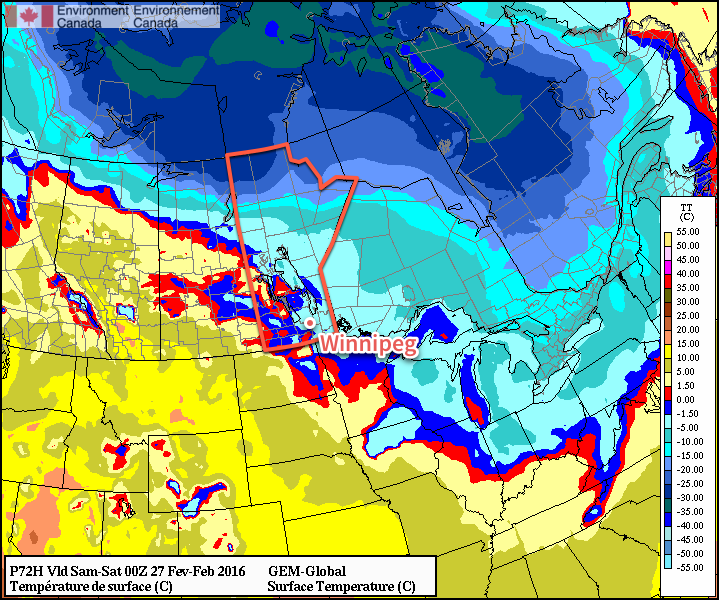
Heading into the weekend, there’s positive agreement that we’ll be heading for cooler temperatures as Arctic air filters southwards. A few flurries may stick around for Saturday morning before the skies clear out. How cold it gets will be largely determined by how a system expected to track through on Sunday develops; some models bring it through Manitoba, keeping temperatures closer to seasonal values and spreading some light snow across the province, while others keep it to the south, giving us clear, cool weather.

NAEFS 8-14 Day Temperature Anomaly Forecast — Valid March 2 to March 9, 2016

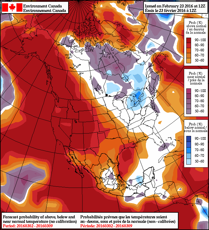
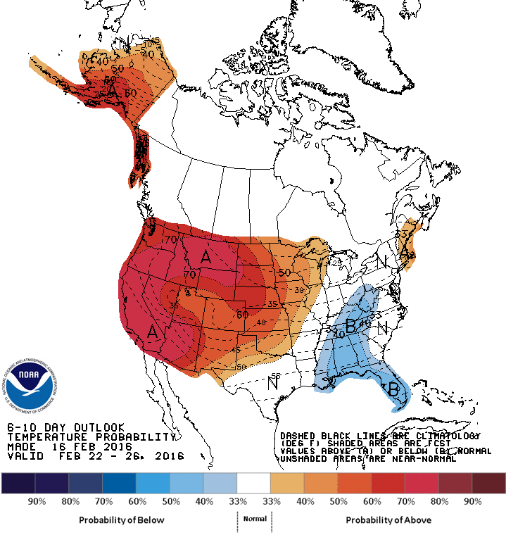
After that it looks like the weather will be relatively quiet with a gradual return towards seasonal temperatures. This is reflected in the NAEFS 8-14 day outlook which shows the above-seasonal temperatures collapsed westwards towards the more prominent west coast upper ridge. Manitoba’s pattern is forecast to be generally northwest, but with multiple shortwaves moving through over the 6-12 day time-frame. This would translate to variable temperatures as we see warmer than normal temperatures as disturbances roll through and then cooler than normal temperatures behind these systems.

All in all, much like we’ve been seeing lately! We’ve hit the point now, though, where we can be happy with near-normal temperatures since normal daytime highs continue to gradually march towards 0°C!

Winnipeg’s seasonal daytime high is currently -6°C while the seasonal overnight low is -16°C.

Mild Weather Early This Week

This week will start out mild, with temperatures just below the freezing mark. However, colder weather appears to be on the way for the weekend.

Today will be mainly cloudy with some flurry activity. A low pressure system to our north will push southward during the day, ushering in this light snowfall. We’ll be in the warm sector of this low pressure system, allowing us to experience mild temperatures just below the freezing mark. Winds will also be light, making for a generally nice day.

Southern Manitoba will be in the warm sector on Monday

Tuesday will remain mild, although temperatures will dip slightly in the northerly flow behind Monday’s system. A few flurries may persist on Tuesday, though no significant accumulations are expected. Winds will be breezy from the north at 20-30km/h.

Wednesday will see the continuation of mainly cloudy, but mild conditions. Temperatures will remain just below the freezing mark with flurries likely again. Winds will be light however, making for a grey, but generally decent day.

Long Range

The long range forecast suggests that mild weather will stick around through the remainder of the work-week. However, it appears another arctic blast is on tap for the weekend, bringing temperatures well below normal. Models suggest that this arctic air mass will stick around into next week, although it will be tough for extreme cold conditions to persist as we push into March.

Winnipeg’s seasonal daytime high is currently -6°C while the seasonal overnight low is -17°C.

Mild Friday Leads to Cooler Weekend

The mild weather will continue today with daytime highs of +1 or +2°C today as yet more warm air washes over Southern Manitoba. The system responsible for this mild spell will be making its way across the region today and after it brings some mixed precipitation, it will push eastwards into Ontario, taking the warmth with it. Northerly winds will develop tonight and begin to usher in cooler, more seasonal temperatures.

Today will bring some more organized precipitation across the Red River Valley as the main disturbance that’s been responsible for the warmth this week moves across the region. With temperatures so close to the freezing mark, what type of precipitation will be falling is a bit of a difficult question to answer. Looking at the Red River Valley as a whole, we can say that there will be mixed precipitation, however for any one location may see just rain, just snow, or both. Even if snow falls, with the above-0°C temperatures, it won’t be able to accumulate much. By the time the precipitation tapers off, just 1-2 mm of rain or cm of snow will have fallen.

With light winds and above-zero temperatures, it also is possible that drizzle or fog patches are an issue throughout much of the day.

As the system moves into Ontario later today, northerly winds will begin developing over Southern Manitoba and draw in cooler air from the north. Drizzle or freezing drizzle will be possible through the early evening hours, but that risk should dissipate heading into the overnight period. Temperatures will dip to about -6°C with gusty northerly winds up to 30 km/h.

GDPS 850mb Temperature Forecast
The GDPS shows the gradual return of colder air via 850mb temperatures.

Saturday will bring mixed skies and diminishing winds as the Red River Valley sees a weak ridge of high pressure begin to build in. There’s a bit of uncertainty to exactly how much cloud will clear out of the region; it will likely trend towards cloudier, but we should see a few sunny breaks through the day. Temperatures will recover just slightly from the overnight low to a high of -5°C. The colder weather will continue pushing southwards with gradual clearing through the evening & overnight that will allow temperatures to dip to an overnight low near -17°C.

Sunday will bring partly cloudy skies to Winnipeg, but the southern Red River Valley will likely see cloudier skies as a weak low pressure moves through North Dakota. This system will produce some light snow for areas further south, but in Winnipeg there will just be a chance of flurries. Temperatures will be slightly cooler than seasonal with a high of -12°C. Skies should clear on Sunday night as temperatures head to a low near -16°C.

Long Range: Not Cold For Long

This cool-down will be brief; by Monday daytime high temperatures approaching the freezing mark will return to the Red River Valley.

Temperatures will be variable next week with warm days giving way to 1-2 days of seasonal temperatures before warmer weather returns again. No significant precipitation events are expected through next week.

Winnipeg’s seasonal daytime high is currently -7°C while the seasonal overnight low is -18°C.

Warm Weather Brings Unsettled Conditions

Today will mark the start of a prolonged spell of unseasonably warm weather for Southern Manitoba. A strong west-to-southwest flow aloft will begin building into the region today, ushering in much milder Pacific air which will help daytime highs climb above the freezing mark. The milder weather will bring unsettled weather with numerous chances for snow or rain along with the risk for freezing rain over the coming 3-5 days.

Today will bring soaring temperatures as gusty southerly winds develop and raise our temperatures from sub-minus 20 values this morning to around -4 or -3°C by the end of the day. While winds will be light early this morning, they will pick up towards midday to 30-40 km/h out of the south as the warm front towards the Red River Valley. As the warmer air advances eastwards, it will produce scattered flurries that will pass through much of the Red River Valley.

Temperatures will remain steady or drop slightly on Thursday night as more warm air surges northeastwards ahead of an incoming low pressure system. Any remaining flurry activity will taper off overnight, but by Thursday morning the potential for precipitation will return.

RDPS Precipitation Type Forecast for Thursday February 18, 2016

Thursday will be a mild but messy day. A low pressure system tracking across the Southern Prairies will spread a wintery mix of precipitation through the region with pretty much anything possible. With a high of just +1°C, much of the day will bring the potential for flurries or ice pellets, with the risk of freezing rain. At this point it doesn’t appear that amount will be too significant for the Red River Valley, but with a significant chance for freezing precipitation, we’ll be keeping close tabs on it.

Winds will be moderate throughout Thursday morning out of the southeast to about 30-40km/h. Temperatures will climb to near the 0°C mark and then remain there through the remainder of Thursday and through Thursday night. The chance for any type of precipitation (flurries, freezing rain, rain showers) will likely continue through Thursday night.

Friday will see even warmer air push into the Red River Valley with a daytime high near +2°C expected. There will continue to be a chance for flurries in the morning transitioning to rain showers. Winds will remain light until later in the day when a weak cold front swings through and ushers in winds near 30km/h out of the west-northwest.

Long Range: Mild Weather Continues

Looking forward, it looks like the warmer temperatures will remain in place for a while yet. This weekend will remain warm with daytime highs near 0°C on Saturday and -5°C on Sunday, with chances for snow on both days.

CPC 6-10 Day Temperature Anomaly Outlook

Further on into next week, temperatures are forecast to continue above seasonal for this time of year as shown above in the CPC’s 6-10 day temperature outlook.

The normal daytime high for Winnipeg is currently -8°C and the normal overnight low is -18°C.