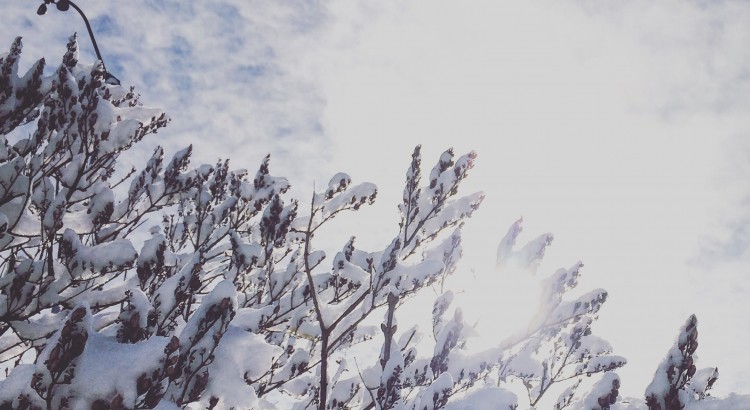
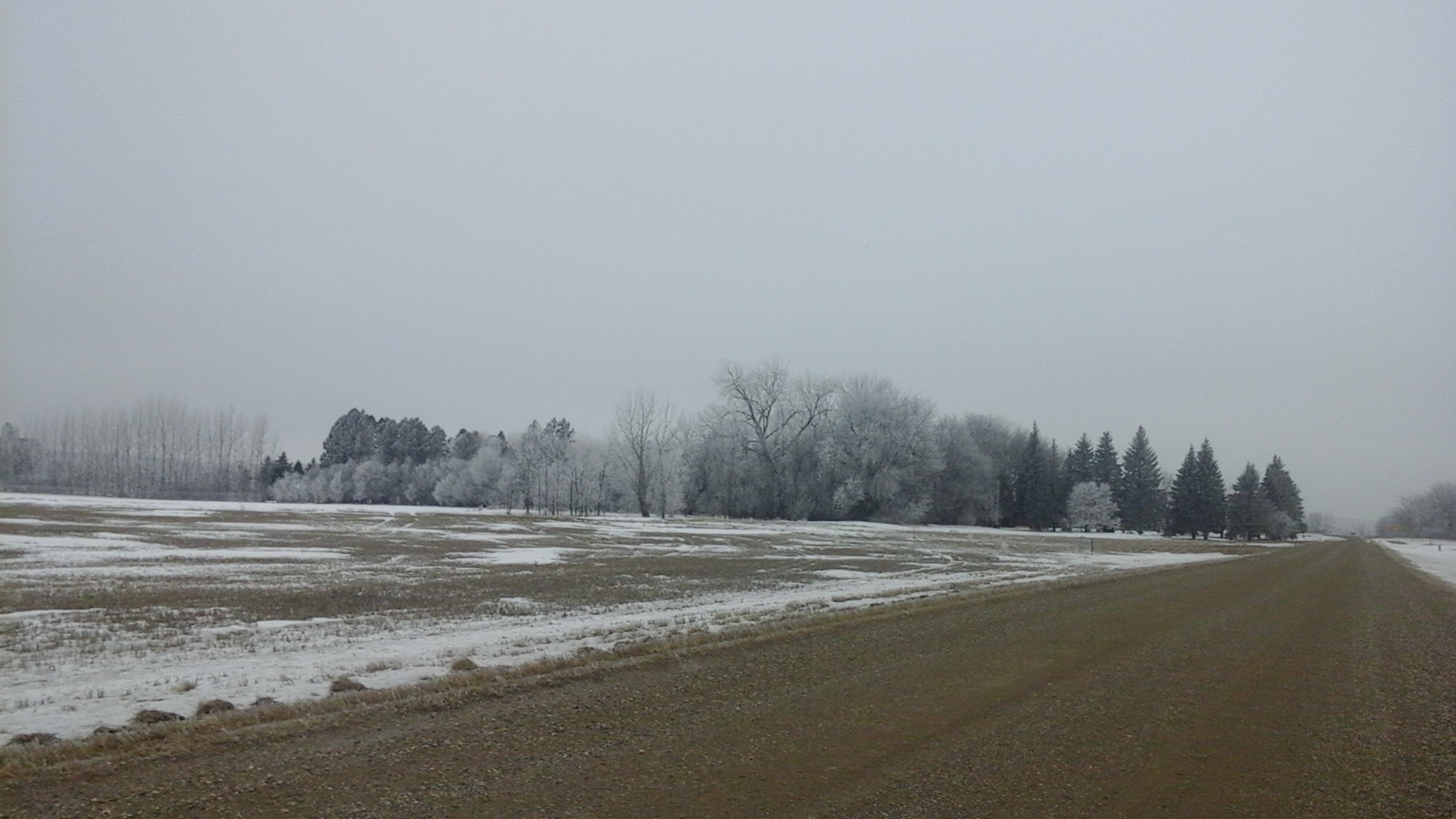
After a stretch of weather that brought record breaking temperatures, record breaking dew points, and new daily rainfall records[1] before shifting into a weird weather pattern that brought moderate-to-heavy snow to much of southern Manitoba (with a rather beautiful aftermath, pictured above), the weather over the coming days will be downright dull as a benign pattern brings seasonal temperatures to Winnipeg.
In a rather nice change of pace, there isn’t too much to talk about regarding this weekend’s weather. Near-seasonal temperatures will be in place throughout the weekend with daytime highs hovering in the 0 to +2°C range while overnight lows hover between -6 to -8°C. Skies will progressively become more cloudy with a sunny day today, a few clouds tomorrow, and mixed skies on Sunday, but no precipitation is expected. Winds will remain quite calm throughout the weekend with the strongest winds on Sunday at just 20km/h or so.
Long Range: More Active Week Ahead
Next week is looking a little more active with a storm system expected to move through on Monday night & Tuesday. It’s too early to try and pin down too many specifics, but overall it appears that it will spread 5-10cm of snow across Southern Manitoba followed by some gusty northerly winds that may produce some local blowing snow.
The GDPS is showing a solution further south than other long-range models, pushing Tuesday’s system southwards into the United States
Towards the end of next weak it also appears that we may see another weak disturbance produce some light snow over the region.
Temperatures will be fairly consistent next week with daytime highs and overnight lows expected to be near-seasonal.
Winnipeg’s seasonal daytime high is currently 0°C while the seasonal overnight low is -10°C.
Winter 2015-2016 brought just what was predicted to southern Manitoba: much warmer than normal conditions, a shorter winter and a lack of major snowstorms overall (except the week before Christmas).
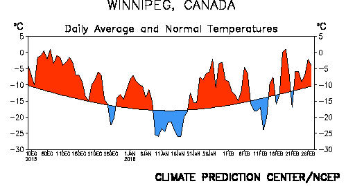
Daily temperature departures from normal from December to February in Winnipeg, via NOAA
One of the Strongest El Ninos on Record
Whether or not this past winter featured the strongest El Nino on record has not been confirmed yet. There are many indices that measure the strength of El Nino and their values are still preliminary. Nonetheless, the Oceanic Nino Index (ONI) is one of the primary indices. It measures the 3-month average sea surface temperature departure from normal in the Nino 3.4 region (the central Equatorial Pacific Ocean). The ONI peaked at 2.3 in the November to January period, tied with the winter of 1997-1998 for highest on record since records began in 1950. Without a doubt, this past winter joined the winters of 1982-1983 and 1997-1998 for the top three strongest El Ninos since 1950.
Category
Total/Average
Deviation From Normal
Rank (Since 1872)
High Temperature
-7.1°C
+ 2.4°C
13th warmest (tie)
Mean Temperature
-11.3°C
+ 3.2°C
9th warmest
Low Temperature
-15.4°C
+4.0°C
7th warmest (tie)
Rainfall
0.4 mm (est.)
- 4.2 mm
69th rainiest (tie)
Snowfall
85.0 cm
+ 23.1 cm
24th snowiest
Precipitation
53.1 mm (est.)
- 1.2 mm
60th driest
A Top 10 Warmest Winter With a Lack of Cold Days
With an average mean temperature of -11.3°C in Winnipeg, winter 2015-2016 was the 9th warmest winter on record since 1872.
Top 10 Warmest Meteorological Winters (Dec-Jan-Feb) in Winnipeg Since 1872
Rank
Mean Temperature
Year(s)
1
-7.2°C
1877-78
2
-8.2°C
1997-98
3
-9.5°C
1986-87
4
-9.7°C
2011-12
5
-10.1°C
1930-31
6
-10.8°C
1991-92, 2005-06
8
-10.9°C
1982-83
9
-11.3°C
2015-16
10
-11.6°C
1999-00
There was a notable lack of cold days from December to February with just 30 days dipping below -20°C. This was well below the 1981-2010 normal of 46 days and tied with the winter of 1918-19 for 8th least -20°C days since 1872. In addition, only 1 day dipped below -30°C, the third least -30°C days on record since 1872. The winters of 1930-1931 and 2011-2012 were the only ones to not see one day below -30°C and this winter was the only one to see just 1 day below -30°C. The 1981-2010 normal is 13 days below -30°C.
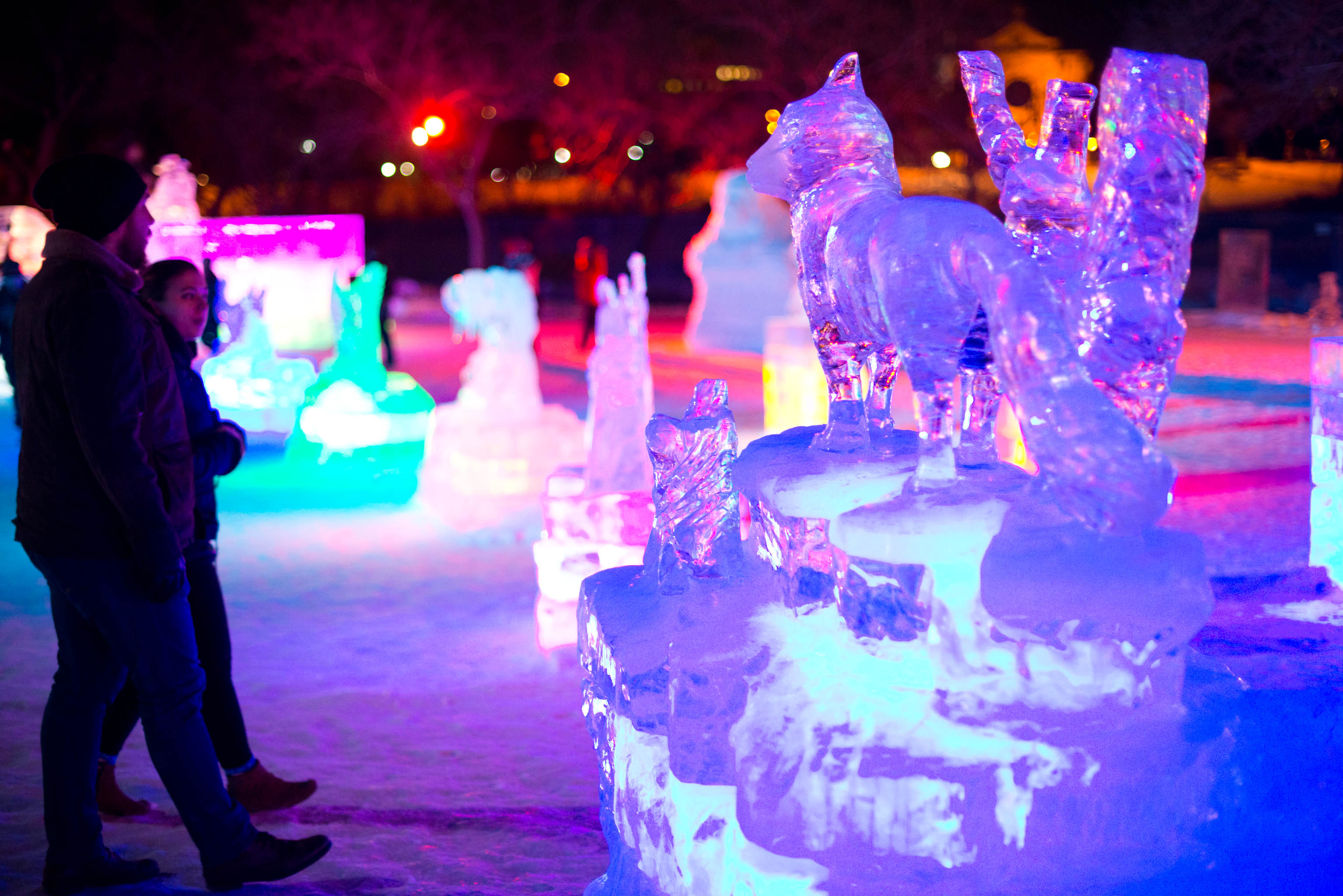
Despite warmth, it was still cold and snowy enough for Winnipeg’s winter festivals. The Ice Show, shown here, was a new addition this winter. Credit: ManitobaHot.com
Winter’s Late Arrival
A significant warm spell occurred in the first half of December, delaying the arrival of sustained winter conditions until mid December. In fact, it was the second warmest first half of December on record since 1872 in Winnipeg with an average mean temperature of -3.0°C. 14-consecutive days from the 3rd to 16th never dropped below -9°C and 8-10 days exceeded freezing. The only record broken during the warm spell was on December 9 when a high of 5.6°C at the airport broke the old record of 5.1°C in 1990. No snow was on the ground in parts of southwestern Manitoba and in the Morden-Winkler area allowing temperatures to reach double digits. In Morden, four days exceeded 10°C, three of which were record highs. The high of 14.2°C on December 4 was the third warmest on record in December since 1904. Some thermometers reportedly reached 15°C, more typical of late September or early October. A similar milestone was reached in Brandon with a high of 11.1°C on the 4th, the third warmest temperature in December since 1890.
In the end, it was the 9th warmest December since 1872 in Winnipeg with an average mean temperature of -8.1°C.
Stormiest Part of Winter
Winter, once it finally arrived, came in with a bang on December 16 thanks to a major Colorado Low. About 20 cm fell in Winnipeg, 18 cm of which fell on December 16 alone breaking the old record of 8.4 cm in 1942 for the day. Two additional snowstorms before Christmas dumped another 20 cm. Thanks to the snowfall, snow depth in Winnipeg sat at 30 cm on Christmas morning, the deepest snow pack on Christmas Day in 15 years (since a 30 cm depth in 2000). In total, 44.0 cm of snow fell in Winnipeg in December, 83% above normal and the 12th snowiest December on record since 1872.
January and February – Mild With Just Two Brief Cold Spells
The worst cold spell of the winter was in early to mid January from the 9th to the 19th. 5 days never rose above -20°C. The coldest night of the winter was on the 17th with a low of -32.3°C, the only -30°C day of the winter. Another brief cold spell occurred from February 8th to 13th, but was not very significant. The coldest temperature was only -27.9°C. Other than that, conditions were near to above normal, making for an easy mid-winter. It was warmest in late January and late February with a combined 8 days above freezing in Winnipeg. The late January warm spell in particular was sufficient to erode much of the snowpack in southwestern Manitoba thanks to warm temperatures and rainfall. Fields were nearly bare from Morden to Melita. Without much snow in February, these areas maintained a very thin to non-existent snowpack up until March. This allowed for warmer temperatures with highs reaching 9°C in Melita in early and late February.
Hoar frost and lack of snow south of Winkler February 1, 2016
In the end, January averaged -14.6°C in Winnipeg, 1.8°C above normal and tied 29th warmest since 1872. February averaged -11.1°C, 2.4°C above normal and tied 22nd warmest since 1873. This was only the second warmer than normal February since 2005.
February Thundersnow
Even some thundersnow occurred not far from the US border in late February, an extremely rare event in this area. One lightning strike was recorded northeast of Altona just after midnight on February 23. Even stronger thundersnow occurred just south of the border near Langdon, ND in the evening on February 28.
Remarkably Warm February Out West
The further west you went in the Prairies, the warmer it was in February. Cold snaps generally remained to the northeast and there was little to no snow on the ground from Melita, MB westward to Calgary, AB. Persistent warmth was the story in this area, especially in southern Alberta. After February 3rd, every single day exceeded the freezing mark in Calgary and this streak has continued into March. In addition, 7 days in February reached double digits with a monthly high of 16.9°C on February 26. There was also a lack of snow with not a single snowfall from February 2nd to 27th. With just 1.8 cm, it was the 5th least snowy February since 1885 in Calgary. Lethbridge, AB was even warmer in February with 15 days reaching double digits. Saskatchewan also received this extreme warmth. Only 11 days failed to exceed the freezing mark in Regina. The monthly high was 13.2°C on February 26, the second warmest temperature on record in February since 1884.
From east to west, here’s how February averaged and ranked across the southern Prairies:
City
Average
Deviation From Normal
Rank
Winnipeg, MB
-11.1°C
+ 2.4°C
22nd warmest (tied)
Brandon, MB
-9.3°C
+ 4.3°C
7th warmest
Regina, SK
-4.5°C
+ 7.6°C
4th warmest
Calgary, AB
1.4°C
+ 6.8°C
2nd warmest
North Dakota Record February Warmth
The warmth was also extreme to our south in North Dakota. Bismarck, located in southwestern North Dakota, reached a record 23°C on February 27. This was the warmest temperature ever recorded in North Dakota in February, breaking the old record of 22°C in 1992.
The shift back to closer-to-seasonal weather will feel like quite an abrupt change given the marked warmth that’s been in place much of March so far. Fortunately, even with the cooler weather, daytime highs will remain above the freezing mark, and with little snow left and not too much expected to fall, it gets harder and harder for the cold air to stick around[1] as the sun continues to increase in strength.
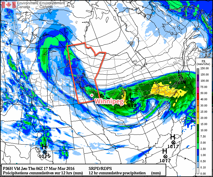
The low pressure that brought yesterday’s rainfall to the Red River Valley will dominate the weather for two more days before things gradually shift to a more neutral set-up.
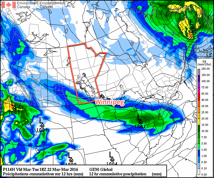
Some say what goes up must come down, and while not typically true about the weather, today we’ll see the area of precipitation that pushed northwards into Central Manitoba slump back southwards throughout the day as an inverted trough extending west-northwestward a from the main low pressure system in NW Ontario rotates southwards around the low. This will result in some showers and cooler air pushing into the Red River Valley through the day. As the precipitation moves in from the northeast, the rain will—at some point—switch over to snow. The flurries will continue through the evening and overnight before tapering off on Thursday morning.
12hour preciptation accumulations forecasted for Wednesday afternoon & evening from the RDPS.
Temperatures will climb to around 3-4°C this afternoon and then drop with the cooler air to a low near -3°C tonight. Winds will fairly breezy today out of the northwest at around 30 km/h with gusts up to 50km/h or so. To the southwest of Winnipeg, winds will likely be a bit stronger at 40 gusting 60 km/h. The winds will ease tonight as the axis of the inverted trough moves into the region.
Thursday will be an unexciting day compared to the past week. Any lingering flurries will taper off early in the morning and leave Winnipeg with mainly cloudy skies and temperatures gradually climbing towards a high of 2°C. Winds will be out of the north at 20-30km/h. Skies will remain cloudy tonight as temperatures dip to a low near -3°C with winds slowly easing off.
Friday will once again bring mainly cloudy skies and a high temperature near 3°C. Winds will be light and no precipitation is expected. Skies will remain fairly cloudy on Friday night as the temperature drops to a low near -2°C.
Winnipeg’s seasonal daytime high is currently -1°C while the seasonal overnight low is -11°C.
Long Range: Continuing Cloudy, Chance of Flurries
Heading into the weekend, it looks like we’ll likely continue to see a fair amount of cloud as a weak trough remains in the region. While Winnipeg won’t likely see any snow, there is a very slight chance of some flurry activity through the region. Should any snow develop, amounts are expected to be minimal and in most cases likely won’t even accumulate. Temperatures are expected to remain slightly above seasonal.
The weather will turn more active next week as a zonal flow develops aloft and multiple shortwaves ripple across the Prairies. Multiple storm systems are forecast to track through next week, each bringing a mix of wintery precipitation. Temperatures will remain slightly warmer than seasonal through the period.
Snow is so effective at keeping temperatures cool due to its white colour. Snow can reflect much of the sun’s energy, limiting the ability for temperatures to warm up. Once the snow cover is reduced or eliminated, the darker ground absorbs more sun and helps temperatures warm up more quickly. ↩
Numerous record were broken across the province from March 11-14, 2016 as abnormal warmth spread across the Southern Prairies. In Winnipeg, the event ended up breaking several record types, including record high temperatures, record high dewpoints, and record daily rainfall amounts.
What caused this anomalous event and what was the overall outcome? Read on to find out!
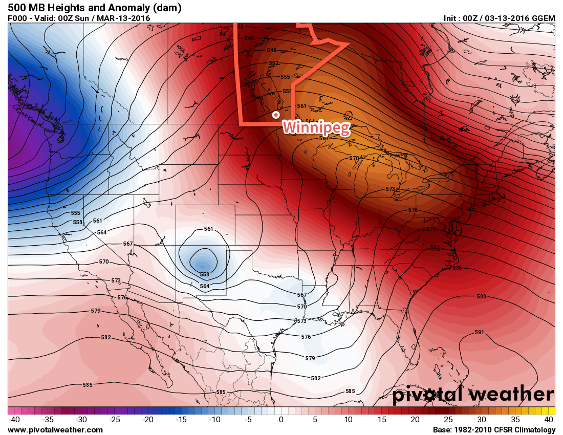
Upper Ridge Brings Anomalous Warmth to the Prairies
GDPS 500mb height anomalies valid the evening of Saturday March 12, 2016
The entire event was precipitated by an anomalous 500mb ridge over much of North America. This feature introduced a broad southwesterly flow through the western Prairies and northern Plains of the US, allowing mild Pacific air to flood eastwards across the region.
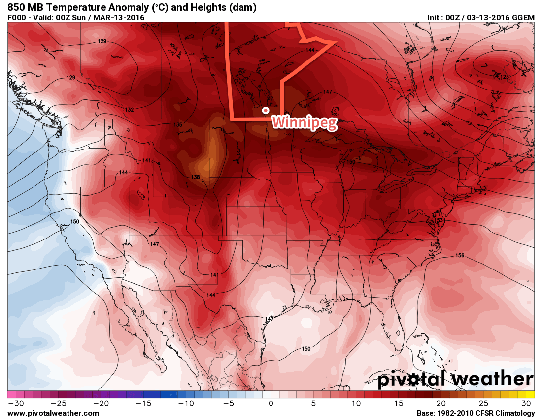
GDPS 850mb temperature anomalies valid the evening of Saturday March 12, 2016
Temperatures ended up well above seasonal values across the entire Prairies. Shown above in the above image, 850mb[1] temperatures were nearly 20°C above normal over southern Manitoba. This translated to very mild temperatures at ground level, with many communities seeing multiple days of record high temperatures.
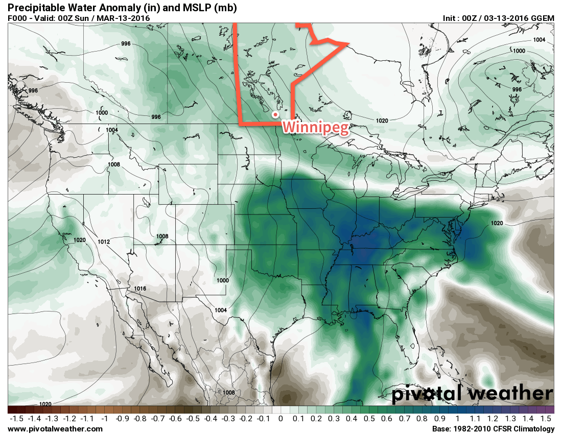
Southerly Feed Enhances Dew Point Values
Additionally, a weak cut-off low over the central Plains resulted in a enhanced southerly component to low-level winds, which tapped into [relatively] humid air to the south and fed it northwards into the province, evident in the above image that shows that there was a higher-than-normal amount of water in the atmosphere over southern Manitoba.
GDPS precipitable water anomalies valid the evening of Saturday March 12, 2016
This resulted in seasonally high dew points for the region. Winnipeg ended up breaking two maximum dew point records on Saturday March 13 and Monday March 14. The anomalous moisture also brought a heavy London-like fog to the region on Sunday night which resulted in a fog advisory for the Red River Valley and southeastern Manitoba as near-zero visibilities blanked the area for over 8 hours.
Wet Transition Out of Pattern Breaks Daily Rainfall Records
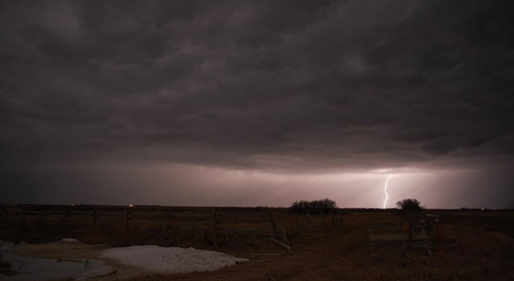
A deep trough began digging into the Western United States on Monday March 14, developing a deep surface trough extending from Northern Alberta all the way to Texas. Ahead of this trough, a southerly feed tapped into moisture-laden air over the southern United States and began pumping it northwards towards Manitoba. As the system organized over the Dakotas on Monday night, it was able to spawn an area of thunderstorms over North Dakota that blossomed into an area of moderate rain as it pushed eastwards through the night.
Twitter user @DusterMB caught this lightning bolt near Killarney, MB on March 14.
Woodlands RADAR at 8:30AM on Tuesday March 15, 2016
This area of rain pushed through southern Manitoba on Tuesday morning, dumping anywhere from 10-20mm of rain over the region. This resulted in a new daily rainfall record for Winnipeg, breaking the prior record of nearly 70 years.
Record Values
In Winnipeg, 4 records were broken through the period of March 11-15, 2016:
Record high temperature in Winnipeg on Saturday, March 12 (New 12.2°C, old 9.7°C set in 2012)
Record high dewpoint in Winnipeg on Sunday, March 13 (new 7.6°C, old 6.7°C set in 2010)
Record high dewpoint in Winnipeg on Monday, March 14 (new 7.7°C, old 6.2°C set in 2012)
Daily rainfall record in Winnipeg on Tuesday, March 15 (New 15.6 mm, old 11.4 mm set in 1946)
However, numerous record high temperatures were broken throughout Manitoba over the 4-day span. Of note was Melita’s high of 20.5°C on Monday, March 14, which marked the earliest 20°C temperature in Manitoba, beating out the prior record of March 16, set by 13 communities in 2012.
Significant Daily High Temperatures across Southern Manitoba on Friday March 11, 2016
Location
High Temperature
Record High
Record High Year
Type
Gretna
14.8°C
8.7°C
2012
New Record High
Melita
15.8°C
14.6°C
2012
New Record High
Pilot Mound
14.1°C
11.8°C
2012
New Record High
Brandon
13.4°C
13.5°C
1981
Near-Record High
Winnipeg
11.6°C
12.8°C
2012
Near-Record High
Significant Daily High Temperatures across Southern Manitoba on Saturday March 12, 2016
Location
High Temperature
Record High
Record High Year
Type
Brandon
12.0°C
11.7°C
1910
New Record High
Gimli
8.6°C
8.5°C
1994
New Record High
Gretna
13.8°C
11.3°C
2012
New Record High
Melita
15.3°C
9.8°C
2007
New Record High
Pilot Mound
12.1°C
9.9°C
2012
New Record High
Pinawa
12.5°C
10.2°C
1996
New Record High
Winnipeg
12.2°C
9.7°C
2012
New Record High
Significant Daily High Temperatures across Southern Manitoba on Sunday March 13, 2016
Location
High Temperature
Record High
Record High Year
Type
Melita
17.7°C
15.5°C
2012
New Record High
Portage la Prairie
15.0°C
13°C
2012
New Record High
Pilot Mound
15.0°C
13°C
2012
New Record High
Island Lake
12.3°C
11.2°C
2010
New Record High
The Pas
11.4°C
11.1°C
1929
New Record High
Thompson
10.1°C
9.6°C
2012
New Record High
Brandon
15.2°C
15.2°C
2012
Tied Record High
Berens River
9.3°C
10.4°C
2012
Near-Record High
Fisher Branch
7.1°C
9°C
2012
Near-Record High
Gretna
11.4°C
12.3°C
2012
Near-Record High
Norway House
8.2°C
8.8°C
2010
Near-Record High
Significant Daily High Temperatures across Southern Manitoba on Monday March 14, 2016
Significant Weather Events in Winnipeg, March 11-15, 2016
Date
Record Type
Value
Record Value
Record Year
March 11
Near-Record High Temperature
11.6°C
12.8°C
2012
March 12
New Record High Temperature
12.2°C
9.7°C
2012
March 13
New Record High Dewpoint
7.6°C
6.7°C
2010
March 14
New Record High Dewpoint
7.7°C
6.2°C
2012
March 14
Near-Record High Temperature
13.1°C
13.2°C
2015
March 15
New Daily Rainfall Record
15.6 mm
11.4 mm
1946
850mb is approximately 1.5km above the ground. This level is favourable to use for temperature anomalies at the moment because it is mostly free of the influences of snow cover. ↩
Melita’s high temperature of 20.5°C on March 14, 2016 marks the earliest date of a ≥ 20°C temperature in Manitoba. The prior record occurred across 13 sites in the province on March 16, 2012. ↩