Sunny, Mild Weekend Ahead

Plenty of sunshine is on tap for the coming weekend throughout the Red River Valley thanks to a developing southwesterly flow of mild, dry air developing through the coming days. As warmer air pushes into the region, temperatures will climb to summer-like values by Sunday with highs reaching the mid-20’s.

Today’s post will be quite short thanks to a distinct shortage of weather to talk about. Today’s weather will be dominated by a ridge of high pressure moving across Southern Manitoba, bringing mainly sunny skies and seasonal daytime highs near the 17 or 18°C mark. There will be a little bit of high cloud skirting the U.S. border as a disturbance moves through, but otherwise, mainly sunny skies will be seen through the Red River Valley. Tonight, expect temperatures to drop to the mid-single digits under clear skies.

Heading into the weekend, a southwesterly flow of warmer air will develop over the region. Daytime highs will climb into the low 20’s with a light southwesterly wind through the valley. A bit of cloud will show up in the afternoon, but overall it will be quite a nice day. Overnight lows on Saturday night will be quite a bit warmer than Friday night, dropping only to around the 10-12°C with the cloud clearing out overnight. Sunday will be a gorgeous day with daytime highs climbing into the mid-20’s under mainly sunny skies. Winds will be a little bit breezy out of the south. Expect overnight lows in the low teens once again on Sunday night.

Mild & Dry Weather Continues Into Next Week

Relatively mild weather is expected to continue into next week and beyond with seasonal or warmer temperatures expected and little precipitation on the horizon.

CPC 8-14 Day Outlook - Issued 17 Sept. 2015
The latest 8-14 day temperature anomaly outlook from the CPC shows a high probability of above-normal temperatures through the September 25 – October 1 period.

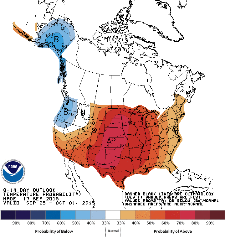
Persistent troughing off west coast of North America is forecast to develop over the coming week, which is often favourable for us here in Southern Manitoba thanks to the southwesterly flow that develops in response. As the large trough develops, the result will be a milder flow of drier air, bringing above-seasonal temperatures to the region. All in all, it means we’ll have a “second summer” of sorts throughout the last half of September, so get out and enjoy!

Unsettled Weather Brings Seasonal Cool-Down

After a pleasant, summer-like start to the week, the weather is set to turn more unsettled as a disturbance rolls through Southern Manitoba tonight. Fortunately, the agitated weather will only bring temperatures back towards seasonal values before we see the heat move back in through the weekend, setting Winnipeg & the Red River Valley up for a hot start to next week.

Today will be a fairly pleasant day in the Red River Valley. There’s a slight chance of some shower activity early this morning as a trough passes through the region, but afterwards we’ll see the cloud begin to clear out through the remainder of the morning leading to just a few clouds this afternoon through the region. Daytime highs will climb to around 21°C–but with significantly less humidity than yesterday–with winds initially out of the northwest at 20–30km/h tapering off through the morning.

The more significant weather will roll into the province this evening as a low pressure system lifts northeastwards out of North Dakota and pushes across southern Manitoba. An area of showers, likely with thunderstorms embedded, will develop across southern Saskatchewan and northeastern Montana and spread eastwards through the night, pushing into southwestern Manitoba early in the evening and then spreading into the Red River Valley and Interlake through the remainder of the night. As is typical with systems that involve convection through the night-time hours, model solutions are a little scatter-shot as to what the outcome will be. Overall, it appears that the bulk of the precipitation will pass to the north of Winnipeg, however some models are coming up with solutions that bring significantly more precipitation into the region.

NAM Forecast Simulated RADAR Reflectivity valid 12Z Thursday September 17, 2015
This simulated RADAR image from the NAM forecast valid on Thursday morning shows a band of heavy, convectively-driven rain over Winnipeg & the Red River Valley.

The NAM-based solutions all tend to produce fairly strong, convectively-driven rainfall over the Red River Valley late tonight into Thursday morning. With PWAT[1] values near 35mm, the rainfall could be quite intense, however strong winds aloft should be moving anything that develops along at a fairly decent clip, meaning overall rainfall accumulations shouldn’t be excessive with around 10–20mm in any heavier precipitation that develops. Outside of thunderstorms/heavy rain cells, the more general rainfall amounts from this system should be around 2–5mm or so in regions south of the Trans-Canada Highway, and closer to the 5–10mm range for areas northwards.

NAM Forecast Sounding for Thursday Morning
This forecast sounding for Winnipeg from the NAM for Thursday morning indicates heavy rain or thunderstorms may be possible.

Temperatures will dip to around 14°C tonight. Thursday will see a high near 15°C with winds increasing out of the northwest to 40 gusting 60km/h in the afternoon. A chance for showers will persist through the remainder of Thursday under mainly cloudy skies.

Friday will bring calmer weather to the region with mainly sunny skies and a high near 19°C. Winds shouldn’t be too bad at around 15–20km/h.

Warmer Weather Returns on the Weekend

Our cool-down to seasonal temperatures will be short-lived, however, as warmer weather is set to build back into Manitoba through the weekend. The upper-level trough that will bring us our unsettled weather will push off to the east and a zonal flow is forecast to quickly develop across the Prairies, pushing in warmer air aloft that will begin to bump our temperatures back upwards. Saturday looks to have a high around 20°C, while Sunday will see the mercury climb towards the mid–20’s.

GPDS Forecast 850mb Temperatures valid 12Z Monday September 21, 2015
This forecast of 850mb temperatures from the GDPS shows temperatures pushing into the upper teens on Monday morning.

The GPDS is forecasting 850mb temperatures pushing into the upper teens through Monday, which would equate to temperatures in the upper 20’s as long as we see the sunshine. Afterwards, it looks like we may see a couple more disturbances roll through in the remainder of the week, bringing temperatures back towards seasonal.

While we will have occasional cool-downs, long-range forecasts continue to forecast above-normal temperatures through the remainder of September.


  1. Precipitable Water  ↩

Above Seasonal Temperatures Continue

The first part of this week will see the continuation of seasonably warm weather.

A push on warm, moist air on Monday night may trigger storms in southern Manitoba

Monday

Today will be near seasonal, with high temperatures around 20C and mainly sunny skies. Winds will light from the east. The main feature worth talking about for Monday’s weather is the risk of thunderstorms overnight. It appears most likely that storms will develop early Tuesday morning near the International border then drift north-east, but some storms may be possible on Monday night as well. The main threats will any storms that develop will be hail and heavy rain.

Tuesday

Tuesday will be a variable day across southern Manitoba. The Red River Valley and south-eastern Manitoba should be hot, with high temperatures in the upper twenties. On the other hand, western Manitoba will likely be cool, with temperatures staying stuck in the teens, along with a good chance of rain.

Wednesday

Wednesday looks to be a pleasant day in southern Manitoba with high temperatures in the low twenties. Winds should be light and skies should be mainly sunny!

Long Range

Long range models suggest normal to above-normal conditions are likely in southern Manitoba for the rest of September. That doesn’t mean we won’t see cooler stretches or weather here and there, but the general pattern should remain on the warmer side.

Japan Faced with Severe Flooding

The worst flooding that some parts of Japan have seen in decades occurred this past week as a tropical storm brought tropical, moisture-laden air to the country.

[map autofit=”1″ disable_scrollwheel=”1″] [pin]Sendai[/pin] [pin tooltip=”Ikari”]Ikari Nikko, Tochigi Prefecture 321-2806[/pin] [pin]Nikko[/pin] [pin]Kanuma[/pin] [pin]Tokyo[/pin] [pin tooltip=”Joso”]Joso, Japan[/pin] [/map]

Tropical storm Etau had the worst impact on Japan’s biggest island, Honshu. Here heavy rain bands were set up for over 24 hours in the area and rainfall totals were further enhanced by local topography. Unstable terrain leading to mudslides also grew to be a concern as heavy rain fell and the ground became saturated. By the end of this past week, when the rain was all said and done, some villages in central and southern Honshu had rainfall totals near 700mm, with some 24 hour totals topping 500mm. It’s to note that the average monthly rainfall for September in Tokyo is less than a third of that (181mm). Here are a few of the notable rainfall amounts (provided by weather.com) :

  • Ikari 551*mm* in 24 hours.
  • Nikko 668*mm* rainfall total.
  • Kanuma 444*mm* in 24 hours, which is more than double the previous 24 hour record for the city (record 212*mm* in 2002).
  • Sendai central business district 269*mm* 24 hour total
Levees of the Kinugawa River breached in Joso from the heavy rains. (Source: AFP/via TWC)

What resulted from these very high rainfall amounts was historic flooding, mainly north and northeast of Tokyo. Over 13,500 buildings were reported to be completely flooded out by officials in result of the heavy rain falling as well as some levees being breached north of Tokyo. In total 3 people have been confirmed to have died from this rainfall event and 23 are still missing; mostly from landslides. It was reported that 185,000 were forced to leave their homes, while over two million more were advised that they should leave by authorities. It’s not possible to assign a dollar amount to the damages yet but authorities speculate it will at least be in the hundreds of millions.

Flooding in the city of Joso, where floodwaters nearly reached the second story of homes. (Source: CNN)

A few showers are expected this weekend in the Tokyo area but nothing close to the magnitude of what seen this past week.