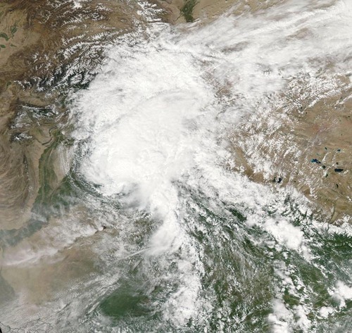
Flooding has been the story for both last weekend and this week as heavy monsoonal rains fell across northern India and Pakistan, having its strongest impact in the Kashmir, Jammu provinces and Jhang district. In this case, the heavy monsoonal rains were caused by very moist air advecting in from the Bay of Bengal due to a low pressure system located in northern India. This moist air was then lifted as it interacted with the rugged terrain of northern India and fell as heavy rain. Satellite estimates show that over 350mm fell in the hardest hit areas in a 7 day period, resulting in rivers overflowing their banks and putting residents at risk.
Satellite image of the low pressure system over northern India; combined with orographic lift, it made for heavy rain in the region. Taken on September 5th. (Source: NASA via Wunderground)
According to news outlets, 5,000 rescues had to be executed in the flooded region as people scrambled to higher ground. When floodwaters will have receded damages will be significant; about 980 villages in the region have seen flooding problems. On Friday night it was reported that 461 people have died due to the flooding with 600 more injured. Some 60,000 residents continue to evacuate to higher ground, not only in concern of flooding waters but also infrastructure being washed out leading to significant transportation problems for food and clean water. In developing countries the residents are typically affected by not only the initial disaster, but also the aftermath of the disaster. This is the case here as water borne diseases are of great concern to officials and will be a true threat to some residents as floodwaters recede. It’s estimated that over one million people have already been affected by this disaster.
In other news several tropical disturbances have formed in the Atlantic, including a tropical storm in the mid-Atlantic. These should be watched in the next few days, however, there is fairly strong shear in the region currently which is causing problems for these storms to develop further.
Cool weather will persist across Southern Manitoba this weekend as the region remains under the influence of an unseasonably cold outbreak of Arctic air. Temperatures will continue to slowly moderate, however things will be generally mixed through the weekend with a fair amount of cloud and slight chance of precipitation. The real warm-up will build into the region next week, returning us to summer-like weather.
Friday
13°C / 4°C
Mainly sunny
Saturday
14°C / 5°C
Mainly cloudy
Sunday
14°C / 5°C
Mixed skies
Today will be the nicest day that the area has seen in a while thanks to a westerly wind which will help dry out the low-levels and clear out the cloud that has been so persistent over the past week. Thanks to that, mainly sunny skies will be seen in Winnipeg and throughout much of the Red River Valley with westerly to southwesterly winds up to around 20km/h. Temperatures will remain cool, however, as the wind will be outflow from the colder air mass slumping to our south; highs through the Red River Valley will sit near the 13°C mark.
Tonight will see mainly clear skies with a little bit of cloud working in from the northwest late in the overnight period and a low near 4°C.
Cool, Mixed Weekend
Saturday will be a mainly cloudy day as a weak trough of low pressure swings through the Red River Valley. While no precipitation looks likely, there will be a slight chance of some isolated, light shower activity. The temperature will climb to around 14°C for a high temperature in the valley.
Skies will begin to clear overnight as the trough slides off into Ontario and winds back to northwesterly, although another slightly cool shot of air will be moving in behind the trough so some cloud with a chance of showers or drizzle in the lee of the lakes is likely. Lows will be near 4 or 5°C in Winnipeg & through the Red River Valley.
Sunday will bring mixed skies with a chance of drizzle or showers in the lee of the lakes. The high will once again be near 14 or 15°C while the overnight low drops to a repeat 5°C.
Warmer Weather Next Week
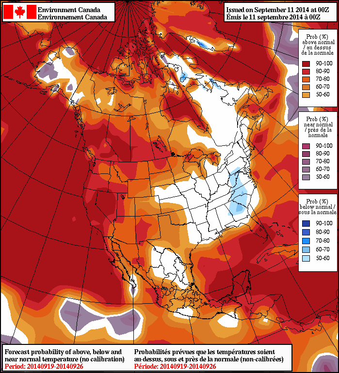
The NAEFS is forecasting above-normal temperatures across Southern Manitoba in the 8–14 day outlook.
Manitobans will be repaid for their patience with the cold weather – if medium-to-long-range enesemble models are to be believed – with a hurried return to summer-like conditions. Both Canadian and American models show an upper-level ridge building eastwards across the Prairies next week brining significantly warmer air with it.
850mb temperatures will climb early next week from the –2°C or so they sit at this morning over Winnipeg to around 10°C. This warming aloft will translate to significantly warmer temperatures down here where we live, with daytime highs moving from low-to-mid teens up to the low 20’s.
The weather also looks fairly dry through the warm-up, although by week’s end there looks to be a chance of showers or thunderstorms as a low pressure complex tracks eastwards through the Prairies & Northern Plains of the United States.
Unfortunately, this week’s plunge into terrible cold for September is far from over, with cooler temperatures still set to work their way into Southern Manitoba. The growing season will be at risk for a tragically early end with frost a slight possibility over the next couple nights here in the Red River Valley.
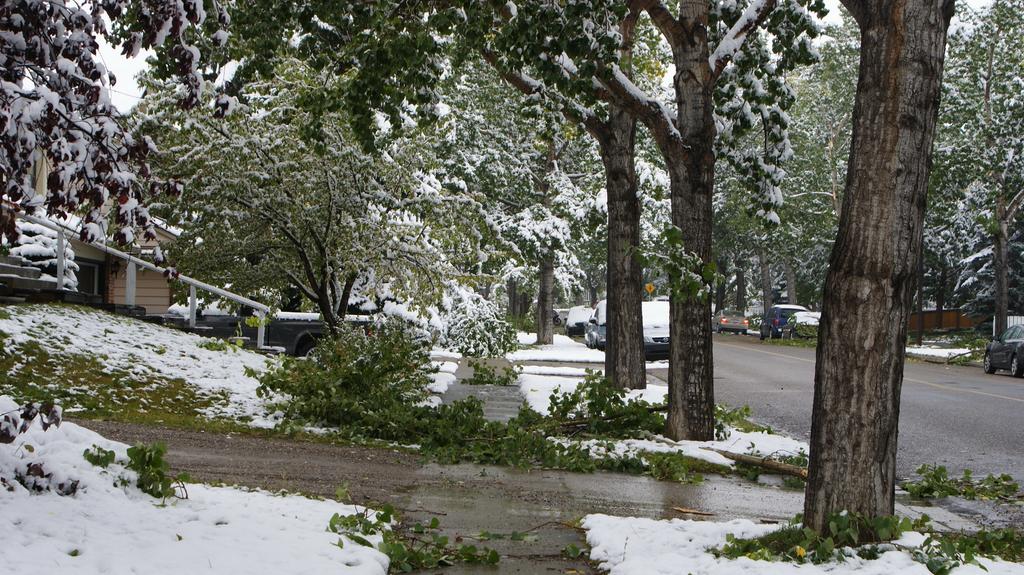
Calgary, AB and its surrounding areas have been hit particularly hard by this early-Fall outbreak of cold weather, with up to 25cm of snow causing all sorts of problems, including broken tree branches as shown in this picture taken in NW Calgary. Credit: @jpaint
The weather story for the Red River Valley over the next few days is dominated by a rather significant high pressure system slumping southwards through Alberta. The 1034mb or stronger high is a result of a large outbreak of cold air from the high Arctic and while the high center is sliding down the foothills of Alberta, the system covers the entire Prairies.
This means that substantially below-normal temperatures[1] accompanied by brisk northerly winds will persist for much of the rest of the week before slightly milder air finally pushes across the Prairies as the high pushes southwards into the United States.
Wednesday
12°C / 2°C
Mixed skies; drizzle possible overnight.
Thursday
12°C / 1°C
Mixed skies
Friday
13°C / 5°C
A few clouds
Today will be a windy day with moderate northerly winds to around 30km/h and a high of only 12°C or so. Skies will be fairly mixed, although it will become more consistently cloudy this evening as cooler air begins working into Southern Manitoba aloft and the lakes begin producing more cloud. By late-evening a slight chance of drizzle will work its way into Winnipeg as north/northeasterly winds bring in cloud streamers off the south basin of Lake Winnipeg. Drizzle or showery weather is more likely near the Portage La Prairie region where Lake Manitoba, under slightly colder air and more favourable wind profiles undergoes more vigorous lake-effect activity.
Temperatures will drop to around 2°C or so, however it’s possible that the temperature drops to the freezing mark with some frost in some of the rural areas in the Red River Valley, depending on where cloud vs. clear skies set up.
Thursday will bring mixed skies again, although the winds should be a bit lighter than today. The high will once again be around 12°C. There will be more cloud from the lakes on Thursday night and a slight chance for some drizzle down-wind of the lakes as we head to a low of around 1°C. Once again, it’s possible some areas see the temperature drop to the freezing mark in rural regions, depending on cloud cover.
Friday will bring a shift in the weather as the high finally slumps to our south and westerly winds work their way in. We won’t see the temperature move much during the day thanks to the fact that, despite the shift in wind, southern Manitoba will still be under the influence of outflow winds from the high. The westerly winds should clear things out, allowing for our sunniest day of the week.
A disturbance will then begin diving southwards from the Northern Prairies on Friday night, spreading cloud ahead of it and slightly milder temperatures aloft. As a result, temperatures will likely be a little warmer on Friday night with lows near 5°C.
Improving Conditions for Next Week
Looking ahead, things look to begin gradually improving on the weekend. Saturday will bring some sun and cloud alongside a slight chance for some shower activity as a weak disturbance trundles through. On the backside of the system lake-effect showers/drizzle will again be possible on Saturday night. Temperatures will likely be limited to the low teens on Saturday.
Sunday will be a nicer day. At this point it looks like it will likely be a mainly sunny day with a high in the mid-teens. There’s some discrepancy in models right now with some models suggesting a mainly cloudy day, others mainly sunny. We’ll have to wait and see what exactly pans out for the day.
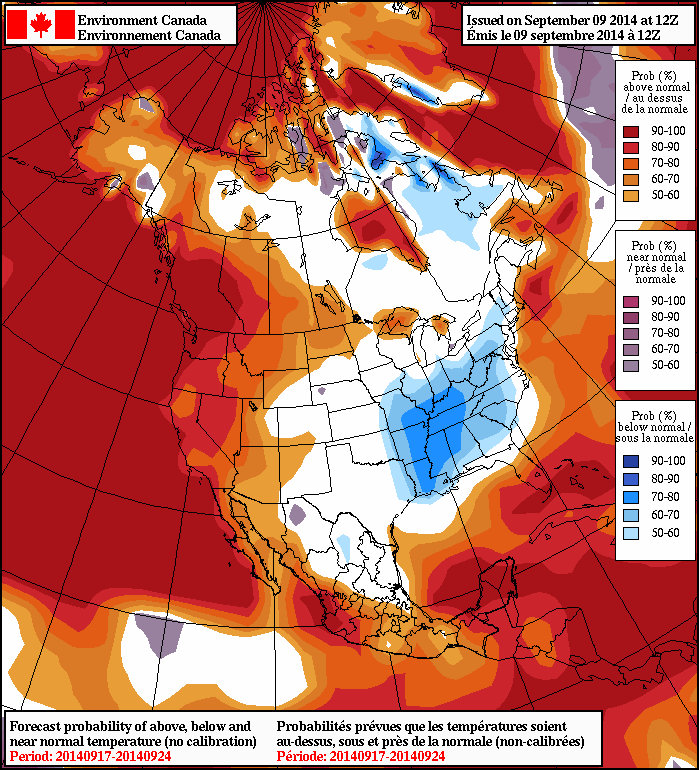
The NAEFS 8–14 day temperature anomaly forecast is calling for above-normal temperatures in Southern Manitoba.
Into next week, it looks like we’ll see a return to summer weather as a surge of warm air spills eastwards across the Prairies. The NAEFS[2] is calling for above-normal temperatures in the 8–14 day outlook, which will be a welcome relief after this very early cold snap. Models are suggesting that next week will be relatively dry, with the potential for rainfall near the end of the week.
Normal temperatures for around August 10th in Winnipeg are highs of 19°C and lows of 7°C. ↩
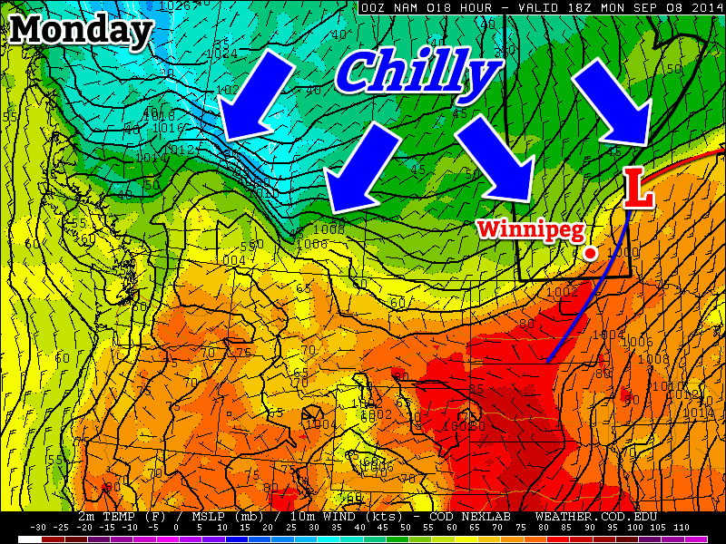
The cold front is coming! The cold front is coming! After a pleasant weekend, things will turn sharply cooler this week as a potent cold front plows through southern Manitoba today.
A cold front will bring sharply cooler weather to southern Manitoba on Monday
Monday
Monday
22°C / 7°C
Mainly cloudy with chance of showers
Today will see a strong cold front sweep through southern Manitoba. The front will move through western Manitoba early in the morning, exiting the province by late afternoon or early evening. There may be a few showers along this cold front, but no significant precipitation is expected. However, temperatures will drop significantly behind the front, and winds will increase as well, marking an end to summery weather, at least for now.
Tuesday
Tuesday
10°C / 4°C
Mainly cloudy with showers
Tuesday will be a nasty day. High temperatures will struggle to reach double-digits and there will be a breezy north wind. To add insult to injury, we may also see some showers throughout the day, just adding to that nasty fall feel. This will be our first taste of fall weather since, well, last fall!
Wednesday
Wednesday
12°C / 2°C
Mix of sun and cloud
Wednesday will be another cool day in southern Manitoba. High temperatures in the low double digits are expected, with a breezy north wind once again.
Long Range
After reading about the gloomy weather above, you’re probably hoping this isn’t it for summer…well, all hope is not lost, at least not yet! Long range models suggest that we may return to a more summery pattern at some point in the second half of September. Let’s hope the long range forecast is correct!