State of the Climate: The Year So Far

Editor’s Note: Something I’ve wanted to do far more frequently than I’ve been able to is comprehensive climate statistics for Winnipeg. In between the regular posts, occasional event summaries and keeping this website humming along, I simply haven’t had the time time to get my personal climate archive quite up to snuff yet to really dig into things. So, I’d like to introduce a new contributor to the AWM team, Julien (@jjcwpg on Twitter). He’s the proprietor of Winnipeg Weather, does fantastic work with climate statistics[1] and will be in charge of seasonal climate updates as well as summer severe weather climatologies, similar to his guest post covering last summer’s thunderstorm statistics across the province. Since Julien is joining the team mid-season, we’re doing a “Year so Far” climate summary to bring readers up to speed on the current climate story for Winnipeg – hint: it’s cold – and to introduce him. So without further ado, here’s the first post of our new feature: State of the Climate!


Quite the year so far!

It’s no secret that 2014 has been an unusually cold year so far; in fact, we’ve managed to reach some impressive milestones in the last few months. Our brutal winter is now long gone and most of you probably want to forget about it (me as well), but before doing so I do have some interesting statistics about the winter of 2013/14 that I think are worth sharing.

To start off, this past December to March period didn’t only feel like one of the harshest ever recorded in Winnipeg, it statistically was. Our mean temperature (an average of all daily highs and lows) was -18.4°C, making it the coldest December to March period in 115 years. However, because we only tied with the winter of 1898-1899 for 11th coldest, we have to go back 121 years to find a December to March period that was even colder than this year’s. With 124.6cm of snowfall, it was also the 12th snowiest December to March period. Combining 12th snowiest with 11th coldest truly made this past winter one of the harshest since records began in Winnipeg in 1872.

In total, there were 90 days below -20°C between December and March, tying 6th most since 1872 and the most in 121 years! That’s 74% of all available days! The 1981-2010 normal is 51 days. The following table summarizes the number of -20°C and -30°C days we had from December to March.

Days below -20°C and -30°C
December 2013 to March 2014
Month Days below -20°C Days below -30°C
December 25 (tied 6th most) 9 (tied 15th most)
January 26 12
February 24 (tied 13th most) 6
March 15 (tied 20th most) 2
Total 90 (tied 6th most) 29 (tied 19th most)
Anything within the top 20 is noted.

The winter minimum was -38.0°C on January 5, the coldest temperature in Winnipeg since a -41.7°C low in February 2007. The high of -30.2°C for the day was not only a record low maximum but also the coldest since a -30.8°C high on Jan 30, 2004.

Many of you might remember the super cold day we had on March 1. Well, I’d say that was the most anomalous day of the winter. The low of -37.0°C that day was actually the 9th coldest in March since 1872. The high of -26.0°C obliterated the old record low maximum of -22.2°C in 1972 and was the second coldest in March on record. The mean temperature for the day was -31.5°C, making it the second coldest March day since 1872. In fact, this was a whopping 21°C below normal for the day, almost as extreme as March 2012’s 23.7°C above normal on March 19, 2012. Of course, to Old Man Winter all this was not enough. A minimum hourly wind chill value of -49.6 at 7 am was the lowest ever in March since 1953. Previous record was -48.8 in 1962.

Cold Not the Only Story of 2014

Despite all the cold weather news to talk about this year, one warm record managed to stand out. On January 15, a high of 3.3°C broke the old record high of 2.2°C in 1973. However, this high was an amazing 30.7°C increase from a low of -27.4°C in the morning, the greatest single-day warmup on record since 1872[2]. The top 5 are given in the table below. The 30.7°C warmup took about 14 hours and peaked between 4 and 5 pm when the temperature rose 5-6°C in just 1 hour.

Top 5 Greatest Calendar-Day Warmups since 1872
Rank Temperature rise of… Date
1 30.7°C Jan 15, 2014
2 30.6°C Jan 20, 1874
2 30.6°C May 12, 1949
4 30.5°C May 19, 1899
4 30.5°C Jan 30, 1934
Note the fact that this statistic doesn’t consider how quickly the temperature rose.

Nonetheless, the cold will forever be remembered as the top story of early 2014.

Stubborn cold continues into spring

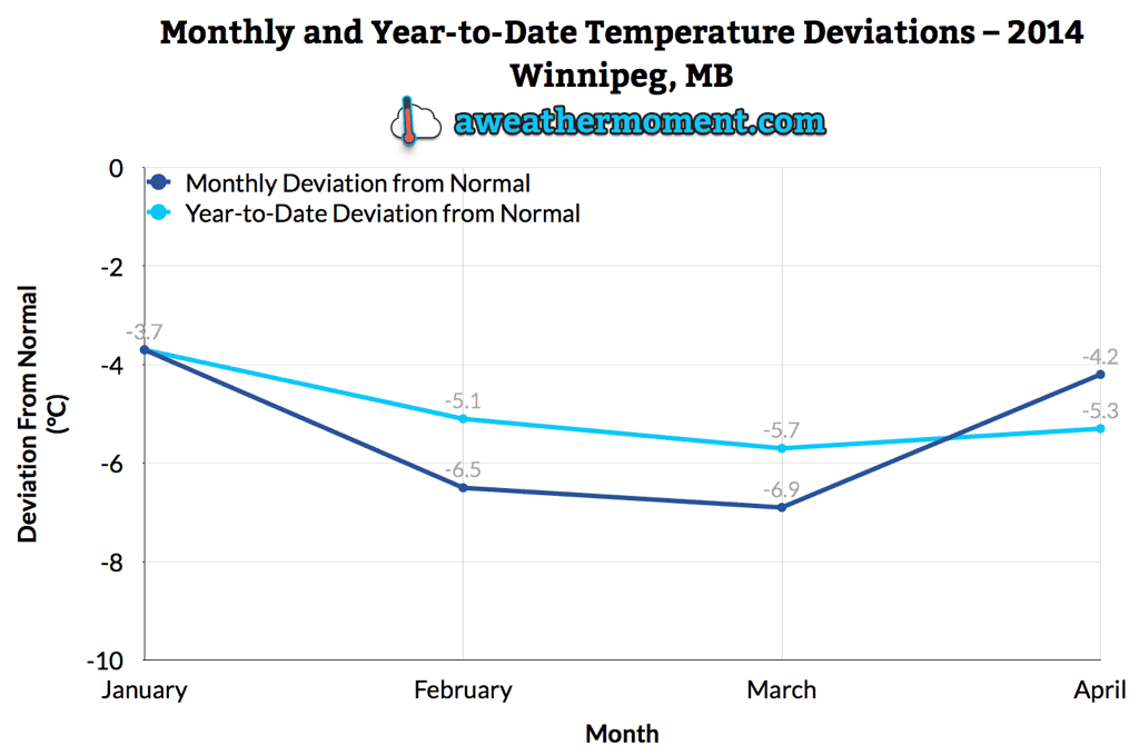
In more recent memory, the cold continued into April with near record lows at times mid month. At 4.2°C below normal, April was the 5th consecutive month averaging over 3.5°C below normal and 7th consecutive month averaging below normal in general; a streak which began in October. In fact, up to April 30 we’ve averaged -13.1°C for 2014, 5.3°C below normal for the period. This ties with 1996 for 15th coldest first third of the year since 1873 and 4th coldest in the last century. The following graph shows how each month so far this year has averaged compared to the 1981-2010 normal as well as the year-to-date average compared to normal.

2014 Monthly and Year-To-Date Temperature Deviations for Winnipeg, MB

Yet another couple impressive statistics have come from this year’s cold. Our winter snow pack still sat at 43cm deep on April 1, the 3rd deepest winter snow pack entering into April since 1955. It didn’t reach a trace cm until April 19, the 3rd latest on record, and disappear until April 21, the 8th latest on record.

Thank you for reading and we hope you all enjoyed this first State of the Climate post!


  1. Seriously, the number of stats he’s worked out is fantastic!  ↩
  2. In this case, when referring to a single day we mean a single calendar day.  ↩

Unsettled Week Ahead

Summer weather will continue to elude us as a complicated weather pattern is set to bring more unsettled weather this week. A series of moderate to strong disturbances will move through Southern Manitoba, each bringing a chance for rain. The first major disturbance looks to move through on Tuesday, with a second major disturbance coming through on Wednesday night.

The forecast surface weather pattern on Monday afternoon

At this point it appears that each of these pieces of energy will just bring light to moderate rain to parts of southern Manitoba. However, there is always the potential for heavier amounts if convective elements (i.e. thunderstorms) become embedded within the larger area of rain. These disturbances will be coming in from the south-west along a strong jet stream.

This strong jet may also be the focus for severe thunderstorms in the US Great Plains this week, so you may wish to keep tabs on that if you’re a thunderstorm enthusiast!

Monday

Monday
12°C / 5°C
Mix of Sun and Cloud

Today will be seasonably cool, with high temperatures in the low teens. Skies will be a mixture of sun and cloud to mainly cloudy, but at least no precipitation is expected. There will be a breezy south wind during the day, but it shouldn’t be quite as windy as it was on the weekend.

Tuesday

Tuesday
15°C / 6°C
Mainly Cloudy. Showers.

Tuesday is expected to feature showers in much of southern Manitoba. There is also a slight risk of a thundershower, which may lead to isolated pockets of heavier rain. Temperatures will be in the low to mid teens with a south wind once again.

Wednesday

Wednesday
15°C / 2°C
Mainly Cloudy. Chance of Showers.

Wednesday will be, you guessed it, unsettled once again, with the threat of showers remaining in southern Manitoba. Temperatures will be in the low teens, with a light northerly wind.

Long Range

The long range forecast suggests we’ll see warmer temperatures this weekend. By warmer, we’re talking probably upper teens or maybe low twenties. It won’t be anything spectacular, but those values will feel quite warm considering the weather we’ve seen as of late.

Elsewhere in Weather News: May 3rd, 2014

Severe Weather, including Tornadoes Rip through United States

It’s been a rough week in the south-central United States for tornadoes. Monday and Tuesday warranted two consecutive high risk outlooks by the SPC for central Arkansas and Mississippi/Alabama, respectively. The system did continue on further to the Carolinas, but conditions weren’t as ripe for tornadoes. As of Friday evening, NWS had confirmed 67 tornadoes from the outbreak and from these, 11 were of EF-3 strength or higher.

Sunday was predicted to be a big day tornado-wise across Arkansas but cloudy conditions in the morning prevented much daytime heating from occurring. A mesoscale convective system (MCS) had also passed through the region the night prior which could have further disturbed the environment. With that said, the environment did manage to sustain a violent supercell in central Arkansas on Sunday which spawned the EF-4 Mayflower/Vilonia tornado. The tornado was on the ground for a length of 66.5km, at its peak produced winds of 300km/h and had a width of 1.2km. Unfortunately 15 people perished from this tornado.

Velocity data of the Mayflower/Vilonia supercell before it hit Mayflower on Sunday. Notice the intense couplet (red and blues are close), a sign of strong rotation. (Source: Radarscope)

Monday was a threatening day with numerous supercells lined up from southern Tennessee all the way down to southern Mississippi, all a posing threat to drop a tornado because of the volatile environment. The Louisville, MS tornado was one of the most significant one spawned on this day, with an EF-4 rating. It tore through the town killing 9 people and injuring several more. The tornado was on the ground for about an hour, traveling 57km. Another town that took a direct hit on that day was Tupelo, MS. The tornado, which had an EF-3 rating, passed through the northern part of the city taking the life of one person.

Supercells across the US South on Monday, notice the overshooting tops associated with the powerful updrafts. (Source: NOAA)

Tornadoes were not the only thing that this system produced on Tuesday night as the MCS stalled out over the Pensacola area of Florida producing flash flood conditions across the region. Interstates were underwater, roads got washed out and parking lots full of cars could be seen underwater. Record-breaking amounts were recorded from this event (provided by Jeff Masters blog):

  • 144mm of rain in one hour
  • 520mm of rain for the event

This weekend the pattern is much calmer across the Southern US and Plains as the atmosphere recharges for the next trough coming ashore next week.

Cool, Unsettled Start to the Weekend

Cool, showery weather will round out another week of below-normal temperatures in the Red River Valley. Unfortunately, we won’t see any significant warming through the next few days, keeping our daytime highs 3-6°C below seasonal1.

The RDPS shows convectively driven rainfall this evening through much of Southern Mantioba.

The weather over the next several days will be dominated by a series of disturbances sliding southeastwards across the province ahead of an incoming cold low aloft. The upper-level flow will keep us locked in cooler air until early next week – at the least – until any sort of significant shift in the overall weather pattern may begin to allow more seasonal warmth to begin working it’s way towards the province.

Friday

Friday
12°C / 2°C
Early morning showers ending then a slight chance of showers through the day. More showers in the evening.

We’ll see a few lingering showers from the overnight period this morning as a low pressure system exits the Red River Valley into Minnesota. The organized preciptiation should taper off fairly early this morning, leaving us with some mixed skies and temperatures on their way to a high of around 11°C.

A weak trough line will extend along a NW/SE line through the Red River Valley, and it’s possible that we may see a few disorganized showers through the day as a result of the daytime heating. If anything develops, it will likely be short-lived and relatively unremarkable thanks to fairly limited low-level instability.

Another low pressure system will slide along the trough line into the Red River Valley this evening, bringing with it another batch of showers. The instability associated with this second low looks rather decent, and if it arrives early in the evening while we’re still near our daytime high, the showers that develop – in particular further to the southwest near the Turtle Mountains and eastwards towards the Pembina Valley – could intensify enough to become a few thunderstorms. There’s no real risk of severe weather, but at this point I think that any sign of summer, even a thundershower or thunderstorm, would be a welcome sight to most people.

The Weekend

Saturday
8°C / -1°C
A few early morning showers, then mainly sunny.

Sunday
10°C / 0°C
Mainly sunny.

Saturday will start out similar to Friday morning, plus or minus a couple hours, as a few showers right underneath the upper-level disturbance associated with Friday night’s low pressure system exit out of the Red River Valley. We’re in for the coolest day of the weekend with a high of only around 8°C as a northerly flow continues to push unseasonal Arctic air southwards over the region. There will be some afternoon cloud that pops up and it should stay at that; the overall level of instability will be quite a bit less than Friday. Saturday night will be another late-season sub-zero night with temperatures dropping to -1 or -2°C through the Red River Valley under clear skies.

Sunday will feature light winds and mainly sunny skies with temperatures climbing to around 11°C. Some cloud cover looks to push in through the evening hours and we’ll see an overnight low near 0°C.

Next Week

The start of next week looks cool with mixed skies for much of the first half of the week. Early indications are that a series of low pressure systems tracking through the Northern Plains will bring showers to Southern Saskatchewan and perhaps southwestern Manitoba, however a blocking ridge will shunt precipitation southwards into the States, leaving us with cool, dry weather and variable cloud. The NAEFS2 continues to predict below-normal temperatures in the 8-14 day range.

  1. Seasonal daytime highs over the next few days sit around 16-17°C.
  2. North American Ensemble Forecast System