A break from the bitter cold snap that we’ve been under the influence of over the past week is on it’s way this weekend.

Behind yesterday’s Alberta clipper system, a zonal flow[1] is pushing into the Prairies and breaking down the entrenched northwesterly flow that has been in place over the past week bringing us multiple nights with overnight lows in the mid-minus 30’s and many daytime highs barely climbing over –25°C. The milder Pacific air contained in the more zonal flow will begin to work it’s way eastwards across Alberta and Saskatchewan today, bringing daytime highs closer to –7 or –8°C instead of –20°C.
Friday
Sunny
-20°C / -29°C
For us in Winnipeg & across the Red River Valley, we’ll face one more day with quite chilly temperatures. Under mainly sunny skies, temperatures will climb to about –20°C with light winds. Temperatures will drop quite a bit tonight as another arctic ridge passes over us; our last cold night before the warmer air pushes in will see us with temperatures bottoming out near –29°C.
Saturday & Sunday
Mix of sun and cloud. Increasing cloudiness overnight.
-12°C / -13°C
We’ll see a mix of sun and cloud on Saturday as the milder Pacific air finally pushes in. Temperatures will climb quite quickly through the late morning and early afternoon from our overnight low all the way up to –12°C by the evening hours. By the evening there may be a few light flurries over the southeast portion of the Province (Whiteshell & Sprague), but through the Red River Valley there’s no significant chance of any snow. Temperatures will remain fairly steady overnight as more clouds push in.
Mainly cloudy. Chance of flurries overnight.
-7°C / -8°C
We’ll see mainly cloudy skies on Sunday as more moisture and lift begin to spread over the province ahead of an approaching shortwave. Temperatures will climb to around –7 or –6°C across Southern Manitoba; the warmest day we’ve had in what seems like quite a long time. Overnight, an increasing chance for light snow will move into the province, starting with southwest Manitoba in the evening hours and slowly spreading eastwards overnight. Temperatures will remain steady, perhaps drop a degree or two, overnight as we remain cloudy with warm air over the region.
Next Week
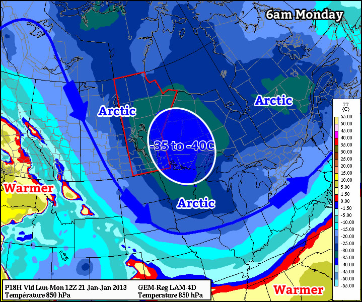
Next week is looking like we’ll see a return to colder weather. There’s some uncertainty with regards to the strength of Monday’s system; it may be a fairly organized feature that brings close to 10cm over SW portions of the province and 5–10cm over the Red River Valley and areas eastwards, or it may end up being a rather disorganized system that brings just some scattered light flurry activity with only a couple cm for most places. With either scenario, it still looks like Monday will be the warmest day yet in our little break from the cold. Unfortunately, it looks that once this system passes, Arctic air will once again push back over the Eastern Prairies and establish itself; locking us back into a sunny, but very cold, weather pattern with daytime highs back near –20°C.
- A zonal flow, with respect to meteorology, is one that travels more west-east than it does north-south. By contrast, a meridional flow is one that has a larger north-south component than west-east. ↩