Windy Start To A Cold Weekend Ahead for Southern Manitoba

An Arctic high’s strong northwest winds will bring unseasonably cold temperatures to Southern Manitoba this weekend.

RDPS 10m Wind Forecast valid 15Z Friday March 25, 2022
Strong northwest winds will be in place over southern Manitoba today.

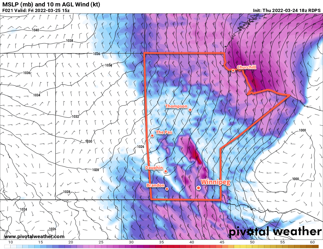
Strong winds blasting through the Red River Valley today will usher in much colder temperatures. Light snow will taper off this morning, leaving behind cloudy conditions as northwest winds of 50 gusting 70 km/h persist through the day. Temperatures will recover only slightly to a high near -6 °C this afternoon.

As the high pushes into the region this evening, skies will clear and the winds will ease. Temperatures will head down close to the -20 °C mark tonight.

RDPS 2m Temperature Forecast valid 09Z Sunday March 27, 2022
Very cold March temperatures will develop on Saturday night underneath the Arctic high over Manitoba.

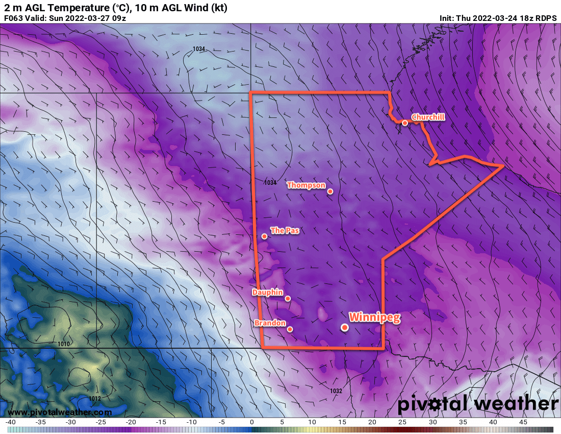
The Arctic high will sit over Manitoba on Saturday, bringing temperatures some 10–20 °C below seasonal values to the region. Skies will be mainly sunny through the weekend with highs near -10 °C on Saturday warming to near -5 °C on Sunday. Overnight lows could dip below -20 °C on Saturday night. Warmer air will begin working into the region by Sunday evening and the low will be much warmer in the -10 to -15 °C range.

Long Range Outlook

Near-seasonal temperatures will return next week with highs back near freezing. Plenty of cloud cover will accompany it with what looks to be a good chance of some snow on Tuesday. The weather pattern looks pretty stable through the rest of the week with highs above freezing, lows below, and variable cloudiness.

Today’s seasonal daytime high in Winnipeg is 2 °C while the seasonal overnight low is -8 °C.

Bitter Cold Continues Across Southern Manitoba

Winnipeg will stay locked in the grip of a deep freeze as a slow-moving Arctic air mass sits entrenched over the region.

RDPS 2m Temperature Forecast valid 12Z Wednesday February 23, 2022
Very cold temperatures will stay entrenched over Manitoba this week.

Temperatures in Winnipeg will sink over 15 °C below seasonal values this week with highs struggling to reach -20 °C. A bitterly cold Arctic air mass has settled over the region behind the train of storms that brought several waves of snow to the region last week. Unfortunately, this air mass is in no hurry and this week will bring little relief will from the cold.

Skies will continue to be mixed today as the region is grazed by a system moving through the United States. Skies will clear tonight, leaving sunny skies for the rest of the week. Daytime highs will sit below -20 °C through much of the week, only breaking into the mid-minus teens on Friday. Overnight lows will be, editorially speaking, terrible; lows will dip below -30 the next couple nights and climb into the low -20s on Thursday night.

Wind chill will be a notable danger today. Northerly winds of 20–30 km/h continue through the day and produce morning wind chills of -45 to -50 easing to the mid-minus 30s in the afternoon. Wind chills will dip back into the -40 to -50 range tonight.

Long Range Outlook

The Arctic grip will begin to break at the end of the week with highs near the -15 to -10 °C range returning to the region. A system moving through will bring a chance for some snow on Saturday, followed by cooler temperatures on Sunday. All indications are that near-seasonal temperatures will return through the first half of next week.

Today’s seasonal daytime high in Winnipeg is -6 °C while the seasonal overnight low is -17 °C.

Warmer Weekend Ahead for Winnipeg, Then Cold Air Returns

Above seasonal temperatures will return to Winnipeg this weekend, but then the Polar Vortex will bring another blast of Arctic air to the Prairies.

Winnipeg will see a seasonably cool conditions today as an Arctic ridge slumps southwards through the day. Temperatures will climb into the mid-teens with mixed morning skies giving way to more consistent sunshine in the afternoon. There’s a small chance of a few flurries with the morning cloud, but any amounts would be very limited.

The next “big” weather system will begin moving into the area on Saturday. Southerly winds will strengthen tonight as a swell of warmer air begins pushing across the Prairies from the northwest. This will bring cloudier conditions back to the region this weekend, but much warmer weather. Temperatures will climb into the -10 to -5 °C range Saturday afternoon, then further to near freezing by Sunday morning. The region will see moderate southerlies up to 40 gusting 60 km/h on Saturday that will ease on Saturday night. The winds will shift northwesterly on Sunday morning.

RPDS 2m Temperature Forecast valid 12Z Sunday January 16, 2022
Temperatures will climb close to the freezing mark by Sunday morning across much of southern Manitoba.

A bit of light snow is possible as the warm front pushes through on Saturday night, then again as a cold front slumps southwards later Sunday morning. Accumulations will be quite low with only a couple centimetres possible.

Cooler weather will then begin to slump back southwards into the region beginning Sunday night.

Long Range Outlook

The main feature driving the weather next week will be the return of cold air associated with the polar vortex. Currently, it sits over much of Baffin Island and into the northern portion of Québec. Next week, though, it will shift westwards and then drop south, re-establishing itself over Hudson Bay again. This will set up a pipeline of cold Arctic air over Manitoba and send daytime highs back down into the minus 20s.

GDPS 2m Temperature Anomaly Forecast valid 12Z Thursday January 20, 2022
The polar vortex will bring temperatures well below seasonal values to the Prairies next week.

There’s a little uncertainty on when exactly it will set back up over the region. Some forecasts show it establishing its influence here by Monday, some others have it’s arrival delayed until mid-week with a bit of cloud and snow moving through in advance. Either way, temperatures will be heading back into the -20s next week for at least 4–6 days.

There is good agreement though that it will not remain locked over the region for a prolonged period. Forecasts show the Polar Vortex once again shifting back towards Baffin Island then northwards again sometime near the end of next week. This will allow warmer temperatures (and cloud, and the renewed chance for snow) back into the region.

Today’s seasonal daytime high in Winnipeg is -13 °C while the seasonal overnight low is -24 °C.

More Snow, Then The Bitter Cold Creeps Back In

An upper low moving into the province will bring more snow to Winnipeg today. Beginning early this morning in Winnipeg, it will continue right through the day and then taper off overnight. This system will drop around 10 cm of new snow across the region. With the low moisture levels seen through the area heading into winter, these recent snowfalls should prove helpful come spring.

Along with the snow, Winnipeg will also see some of the mildest temperatures the city has seen in quite some time. Highs will reach around -14 °C today despite a stiff northerly wind near 30 km/h. As this system pushes off to the east tonight, temperatures will fall back into the mid-minus 20s.

RDPS 24hr. Accumulated Snowfall Forecast (at 10:1 SLR) valid 12Z Wednesday January 5, 2022
Much of southern Manitoba will see snow on Tuesday with 5–10 cm accumulation. The amounts depicted here are a bit underdone; higher SLRs than 10:1 will add about 50% more to the accumulated snowfall in Winnipeg.

Behind this system, colder air will build back into the region as a potent 1045+ mb high slides down the foothills and across the southern Prairies. Temperatures in Winnipeg will drop back into the -20s for highs and likely see lows dipping back below -30 for at least one or two nights later in the week. Extreme cold warnings will make a return for much of the southern Prairies by mid-week; they could reappear here in the Red River Valley for the latter couple days of the work week.

Long Range Outlook

Heading into the end of the week, there are actually some signs of a more substantial pattern change. Several models have the polar vortex over Hudson Bay weakening by the end of the week, shifting off to the northeast, followed by a new centre to the vortex over the High Arctic. This patter change would help break down the persistent northwest flow and/or cold trough over the Prairies and allow milder Pacific air to begin mixing into the region.

GDPS 500mb Height Anomaly Forecast valid 12Z Wednesday January 12, 2022
This forecast of upper level heights (and their anomaly from normal) for the middle of next week shows clearly the collapse of the Polar Vortex back to the High Arctic and the development of upper ridging over the Prairies.

But before any substantial change occurs, there would likely be a period of highly variable temperatures as disturbances move through the region. The first one looks like it might move through on Friday night into Saturday, bringing another chance of snow to the region with highs climbing back towards seasonal values on Saturday. Temperatures would likely cool down behind this system for a few cold days, then warm again mid-week.

Some forecast models suggest that a milder trend may establish itself next week, moving the region into a multi-day pattern of perhaps even seasonably mild temperatures. At this point, one certainly can hope! In the meantime, maybe the cold temperatures can kill off a few pest insects while we wait.

Today’s seasonal daytime high in Winnipeg is -13 °C while the seasonal overnight low is -23 °C.