A slow-moving system to the southwest will keep skies cloudy in Winnipeg the next couple days. The sun returns on Sunday with temperatures warming up to start the week.
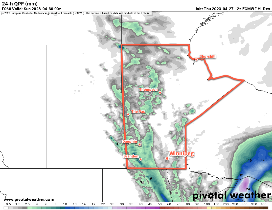
A slow moving disturbance will bring cloud to the Red River Valley, but will dump copious amounts of rain to the west.
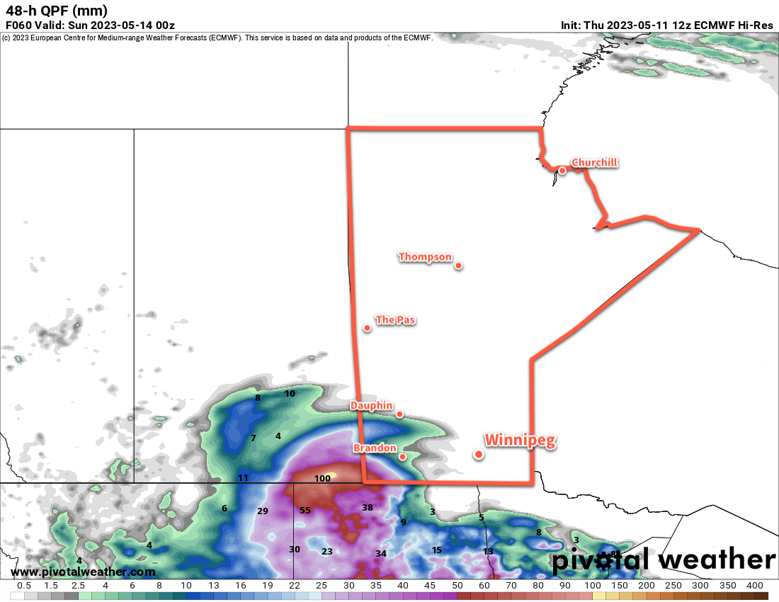
The main weather-maker over the next couple days will be a slow-moving complex of upper lows that extends from northeastern Montana to the central American Plains. This system will keep skies cloudy over the Red River Valley, but is bringing more inclement weather further west. Rain will persist across portions of SE Saskatchewan and SW Manitoba over the next few days, which has triggered an overland flood warning for parts of the impacted region.
For Winnipeg, though, dry northeasterly winds coming out of an area of high pressure to the north will help keep the rain west and south of the city. Winds will reach around 30 gusting 50 km/h both today and Saturday, then ease into the 10 to 20 km/h range at night.
Temperatures will continue mild, though, with highs in the 20 to 25 °C range over the next couple days and overnight lows in the low teens tonight and high single digits on Saturday night.
Everything begins to change on Sunday, though. The slow-moving system will be punted eastwards as a strong upper ridge builds across the Prairies. This will bring sunny skies back to the region and start sending highs up. Sunday will bring high temperatures back into the mid-20s and overnight lows into the low teens.
Long Range Outlook
The upper ridge over the Prairies will dominate the weather across southern Manitoba through the first half of next week. Daytime highs will climb into the upper 20s with plenty of sunshine.
This system will also likely result in the intensification of forest fires in the western Prairies and British Columbia. It’s too early to tell at this point, but there’s a chance that parts of southern Manitoba may end up seeing some hazy skies later in the week if smoke begins to drift into the region.
An upper low will begin digging into the ridge mid-week, and could bring some unsettled conditions to southern Manitoba in the second half of next week.
Today’s seasonal daytime high in Winnipeg is 19 °C while the seasonal overnight low is 5 °C.
Seasonably cool temperatures will stick around for Winnipeg this weekend — along with some unsettled weather — but a big warm up is on the way for next week.
Showers will drop through Manitoba on Friday night into Saturday.
To wrap up the work week in Winnipeg, any morning fog will burn off as temperatures head to a high in the low teens for the afternoon. The region will see mixed skies today with light north-northwest winds.
The next disturbance to impact the region will begin moving in tonight. Skies will cloud up tonight with showers pushing into the Red River Valley from the northwest by morning. Temperatures will head to a low near 2 or 3 °C tonight.
Saturday will bring mostly cloudy conditions to the region with the chance for some sunny breaks in the afternoon. The most organized shower activity will move through the region in the morning, but much of the activity may end keeping west of Winnipeg. Temperatures will climb to a high near 10 °C as northerly winds pick up to around 20 km/h. A few pop-up showers will be possible in the afternoon in the unstable northerly flow that develops.
Skies will clear out on Saturday night with a northerly breeze. Temperatures will dip to a low again in the low single digits.
Sunday will bring partly cloudy skies to the region with a high in the low teens. It will be a breezier day with north winds picking up as high as 30 gusting 50 km/h. It’ll be a cool night on Sunday night with a low near the freezing mark.
Long Range Outlook
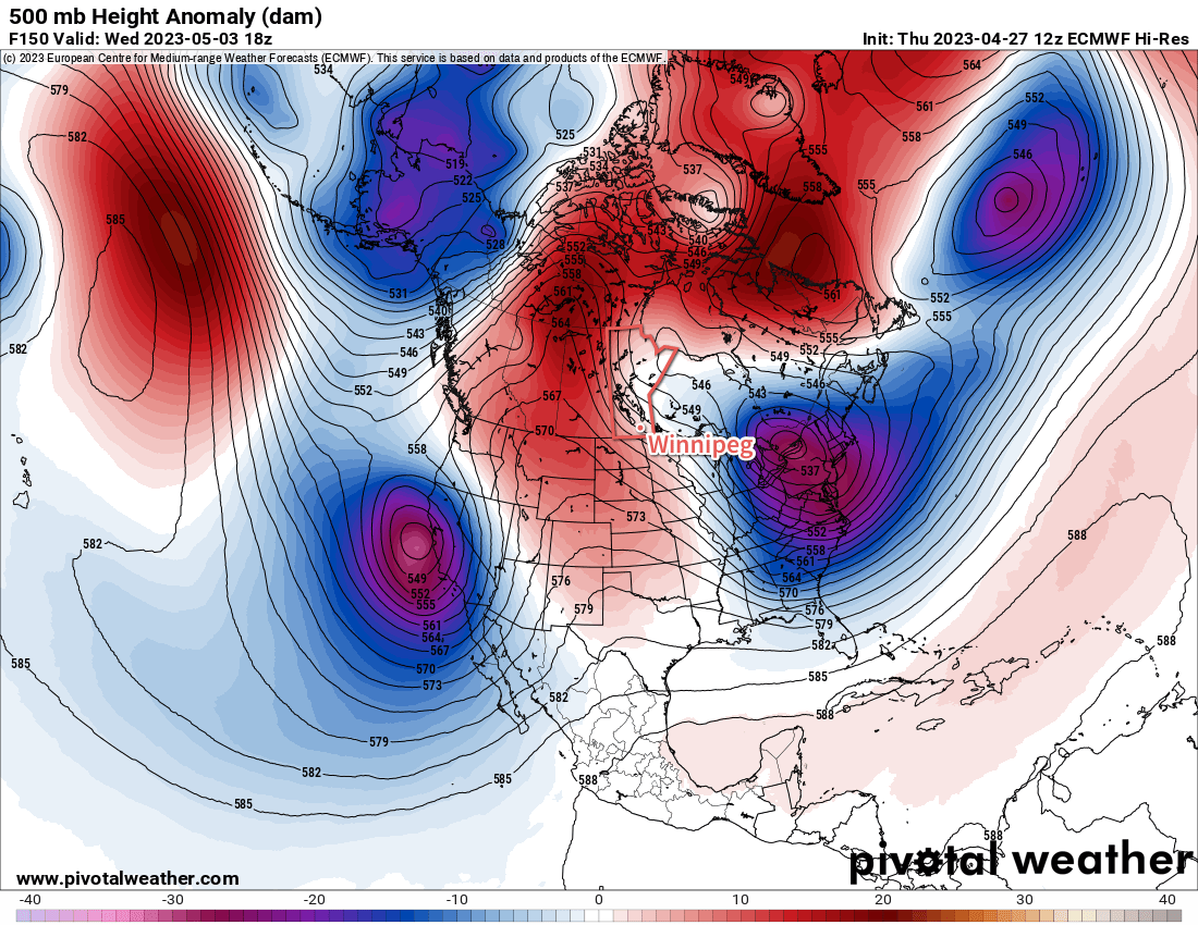
Heading into next week, a major pattern change will bring a substantial change to the weather across Manitoba. The cool temperatures of the last while have largely been due to a persistent upper-level vortex over Hudson Bay. Heading into next week, there’s high confidence that feature will finally collapse southwards into Ontario, then shunt eastwards and out of the region.
The upper-level pattern will then begin to reorganize itself over a few days, with the most prominent trend being a building upper ridge over western North America. As a result, by the end of the week, a well-formed upper ridge is forecast over much of the western United States, the Canadian Prairies, and central Arctic.
A strengthening upper ridge (red shading) will build into western Canada and the Arctic by the middle of next week.
The end result of that will be that next week will see relatively little by way of precipitation and substantially warming temperatures. Daytime highs in southern Manitoba will likely climb into the 20s by Tuesday or Wednesday, followed by highs in the 15 to 25 °C range through the rest of the week.
So after one more weekend on the cool side of seasonal, some spring/early-summer warmth will arrive next week!
Today’s seasonal daytime high in Winnipeg is 15 °C while the seasonal overnight low is +2 °C.
A strong upper ridge will spread a much warmer air mass into the eastern Prairies this weekend, marking the start of a widespread spring melt.
True-colour satellite imagery from Thursday evening reveals a widespread snowpack (white) across much of southern Saskatchewan, southern Manitoba, and North Dakota.
As we mentioned on Tuesday, southern Manitoba will see a much warmer air mass move into the region this weekend as upper ridging persists over western Canada. While this feature will produce plenty of warm air that will head east, the biggest wrinkle in the whole thing is the extensive snow pack across southern Manitoba and North Dakota.
This deep layer of snow will keep the surface cooler and help support an inversion across the region. An inversion is when temperature warms as you go up instead of cooling. This can effectively limit the ability for the warmer air over top of the surface to reach down to the ground.
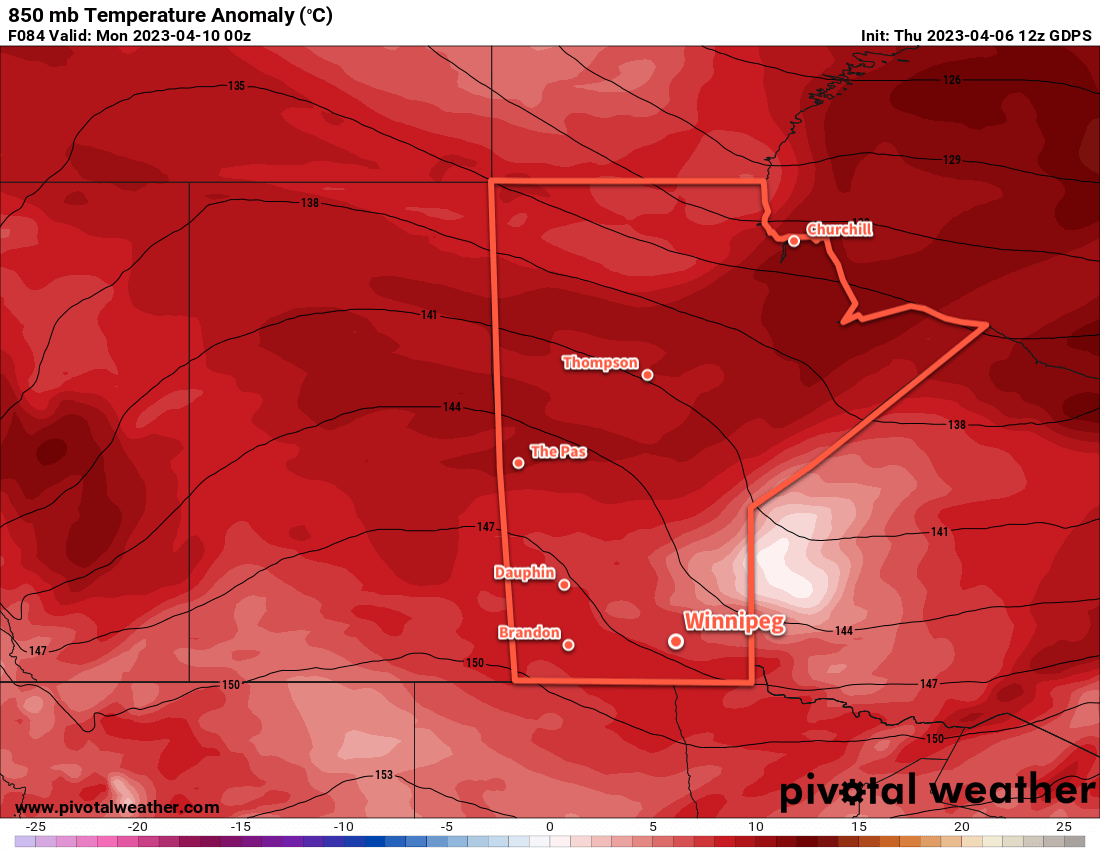
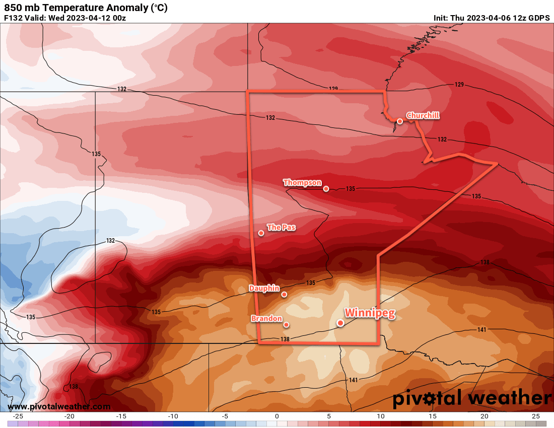
Mild air will certainly stream into the province this weekend. Temperatures at 850 mb — about 1.5 km above the ground — will climb from around 0 °C on Saturday to warmer than 15 °C on Tuesday into Wednesday. Now, if we had full sunshine and dry, bare ground, that could result in daytime highs climbing from the low teens into the upper 20s. But the snow will absolutely keep temperatures much cooler than that.
850mb temperature anomalies — how much warmer or colder than the seasonal average values — show the entire Prairies seeing a seasonably mild air mass by the end of the weekend (left image). Heading into next week, though, the air mass becomes unseasonably warm over the southeastern Prairies (right image). How this abnormal warmth will interact with the existing snowpack is unclear at this time.
The other factor to pay attention to that will dramatically impact how quickly the snow melts will be the dew point temperature. When the dew point is below freezing, it is easy for water that is draining through the snowpack to re-freeze within it. But when the dew point climbs above freezing, that process becomes much harder and the rate the snow pack will melt at increases. The dew point will likely climb to the positive side of freezing this weekend, then increase several degrees above freezing next week as the warmer air pushes into the region.
The last factor to take into account is what all this water that’s melting out of the snow will do. With warming temperatures aloft and a strong inversion, that moisture will be trapped near the surface. This could result in the development of fog and low clouds as the melt picks up, which would also work to reduce potential high temperatures and produce cloudier conditions that really lock temperatures fairly close to freezing. It’s simply impossible to tell at this time if that will happen this weekend, but it’s a possibility to keep in mind.
So all that said, what can we expect?
After a cold start to the morning, temperatures will climb to a high near freezing this afternoon with a light southerly wind. Temperatures will dip back down into the minus teens tonight, the the warmer air mass begins building in this weekend.
Temperatures will climb to a high a few degrees above freezing on Saturday and Sunday with light southerly winds continuing. Overnight lows will be much warmer, just dipping below freezing overnight on both nights. Conditions will likely be sunny, but particularly beginning Saturday night there may be a chance of seeing widespread fog or low cloud develop. If it does, it could persist through Sunday and into the start of next week.
The snowpack will likely begin to melt at a faster rate as dew point values climb above freezing on the weekend.
Long Range Outlook
Next week will start off with a very warm air mass moving over the region, with the large question mark of how the near-surface layer will interact with the snowpack. Continued southerly winds will likely serve to reinforce the low-level inversion, but the sheer magnitude of the warm air will likely result in either (a) temperatures climbing towards 10 °C or even warmer in any areas with an eroded snow pack, or (b) widespread development of low cloud that results in near-surface temperatures again only a few degrees above freezing.
It’s simply too early to know exactly how that will go at this point, but we’ll be keeping an eye on things through the weekend.
One thing for sure is that substantial amounts of snow will melt next week, both in southern Manitoba as well as North Dakota. The water may appear relatively quickly, so we encourage anybody in areas that may need to be concerned about flooding to keep a close eye on updated flood conditions and forecasts. Moderate to major flooding is possible along parts of the Red River in North Dakota and Manitoba. Depending on the rate of snowpack melt in Manitoba, overland flooding may also be an issue beginning next week.
Fortunately, there is little risk for any notable precipitation across southern Manitoba over the coming week.
Today’s seasonal daytime high in Winnipeg is 7 °C while the seasonal overnight low is -4 °C.
Below-seasonal temperatures will continue in Winnipeg this week as temperatures gradually ease back towards the 0 °C mark. The cool conditions and strengthening sun will help flood conditions a bit by gradually evaporating water from the snow pack over the region.
Temperatures will begin a push back towards seasonal values later this week.
The coldest night of the week is now behind us, and the Arctic high responsible for it is gradually shifting off to the southeast. Temperatures will remain cool today with highs once again near -10 °C and lows dipping back to around the -20 °C mark tonight. At least we’ll see plenty of sunshine!
After that, a gradual warm-up will begin as the Polar Vortex begins to weaken over Hudson Bay. This won’t mean a huge warmup for us though, because rather than shifting back into the High Arctic, the Polar Vortex will still stay relatively far south and keep a northwesterly flow over the region. Daytime highs will jump back into the -5 to 0 °C range mid-week with overnight lows in the -10 to -15 °C range.
The region will see some cloud on Thursday as a low pressure system drops out of the Northwest Territories into central Manitoba. Any snow will likely remain well to the north of Winnipeg, perhaps not even moving out of central Manitoba. More sun should return to the region on Friday, but some cloud might work its way into the region as a low passes by to the south of the province.
Long Range Outlook
Heading into the weekend, temperatures will finally reach freezing, with highs of above zero even possible. A system passing through the region on Sunday will bring some more cloud to the region along with a chance of snow.
Today’s seasonal daytime high in Winnipeg is 4 °C while the seasonal overnight low is -7 °C.