This week will be significantly cooler than last week as we see cooler air filter down from the north. However, temperatures will remain at, or slightly above, seasonal values.
Monday
Today will see temperatures in the low to mid twenties under a mixture of sun and cloud. There may be a few showers throughout the day as we remain behind a departing low pressure system. Winds will be breezy from the south-west.
Tuesday
Tuesday will be a mainly cloudy day with a strong likelihood of showers. Despite the departure of Monday’s low pressure system, a large upper disturbance will remain to our north, helping to generate additional precipitation. Accumulations from these showers isn’t expected to be large, but the chance for more rain is definitely not welcome in most of southern Manitoba.
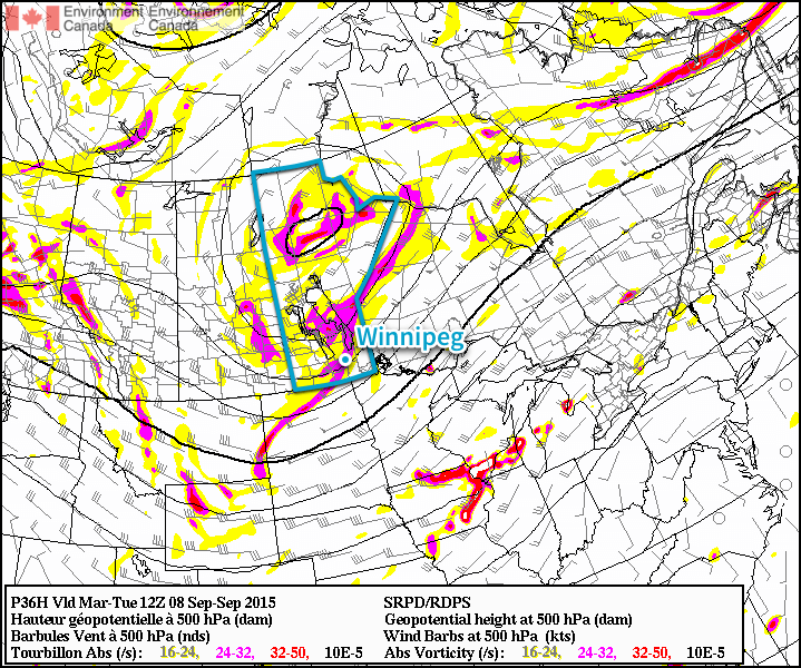
Shown here by the RDPS 500mb forecast, a large upper-level low will impact much of Manitoba on Tuesday.
Wednesday
Wednesday will see very similar conditions to Tuesday. There will once again be a strong chance of rain, with accumulations perhaps a bit higher than Tuesday. This round of rainfall will be the result of a new system moving up from the northern United States.
Long Range
The long range forecast suggests we’ll generally see near seasonal conditions over the next week, which means high temperatures near 20C. At this point long range models suggest we may turn toward cooler conditions by mid-month, but it’s too early to tell if that will come to fruition.
Conditions were ripe overnight Friday into Saturday morning in Central Italy for severe thunderstorms – these brought very large, damaging hail to the region.
A large upper level trough to the west of Italy, slowly digging eastward provided sufficient lift, as well as strong upper level winds contributing to sufficient shear being in place for severe storms. Ahead of this trough, a large area of very warm, moist air originating from the Mediterranean was present. In this warm and unstable environment, MLCAPEs of 3,000J/kg were in place which was more than enough to sustain strong updrafts. Finally, slicing into this airmass was the cold front which acted as a mechanism to trigger the storms. With all of this combined ESTOFEX (European Forecasting Storm Experiment) had issued a maximum level three watch area – meaning that there was a 15% chance of “extremely severe weather” being reported within the area of concern.
One of the numerous pictures posted on Twitter from the hail storm near Naples. (Source: UKWeatherLive)
Impressive visible satellite image of the supercell while it was over Pozzuoli. (Source: EUmetsat)
This forecast definitely checked out. On Saturday morning, local time, a supercell fired over the Tyrrhenian Sea (which later evolved into a well-organized MCS) and brought with it 10-12cm diameter hail to the city of Pozzuoli Italy, located near Naples. To put this into perspective, you would need an updraft velocity speed of roughly 170km/h to suspend a hailstone of that size. Widespread damage occurred to an estimated 70,000 buildings, vehicles could be seen with major dents and blown out windshields and crops/livestock sustained major damage in the area, thankfully there were no injuries to residents reported.
Friday will bring a severe thunderstorm threat to Winnipeg & the Red River Valley as the first of several bouts of unsettled weather moves through, gradually flushing out the unseasonal heat and humidity and transitioning us towards almost fall-like weather.
Friday
29°C / 18°C
Mainly cloudy; showers and thunderstorms this afternoon
Saturday
24°C / 17°C
Mainly cloudy; slight chance of showers. Evening showers or thunderstorms possible
Sunday
24°C / 11°C
Mainly cloudy; slight chance of drizzle or light rain
Mainly cloudy skies will be over Winnipeg & the Red River Valley today while a low pressure system gather steam and begins to move into the region from North Dakota. Little in the way of weather is expected until the low approaches this afternoon and triggers a substantial amount of convective activity. Showers and thunderstorms are expected to fire up mid-afternoon and track to the northeast. There’s a decent chance that the stormy weather will persist well into the evening before it clears out and moves off to the northeast.
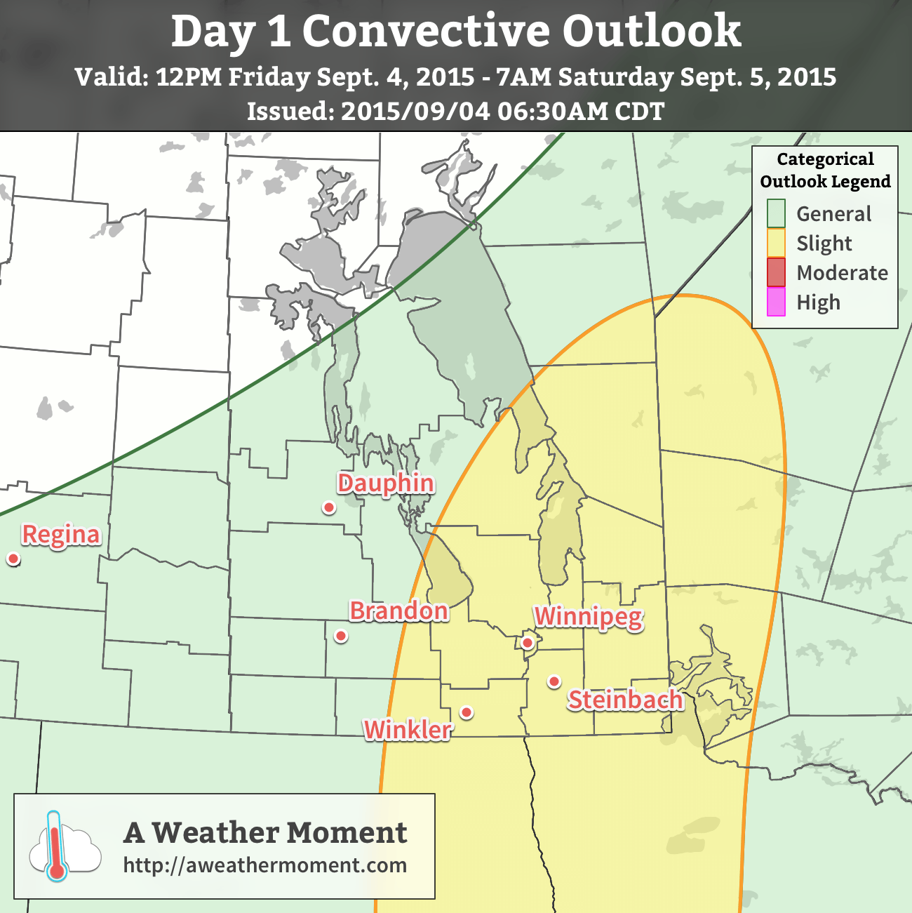
A slight risk of severe thunderstorms exists over south-central and southeastern Manitoba today.
A slight risk for severe thunderstorms will be in place over much of south-central and southeastern Manitoba today. Looking at the MIST basics for thunderstorms:
Moisture will be ample with deep boundary layer moisture evident through surface dewpoint values near 22°C thanks to a multi-day build-up of humidity in a southeasterly flow. Strong evidence of the substantial moisture in place is shown by the precipitable water values which are forecast to climb over 50mm through the afternoon.
Instability will moderate with MLCAPE values around 2000–2500 J/kg. Much of the instability will be brought through the substantial moisture present since mid-level lapse rates are only expected to be moderate and not excessively steep.
Shear will be ample with approximately 25–35kt of 0–6km bulk shear and broadly looping hodographs. This should support the development of organized thunderstorms.
Trigger: there will be several triggers converging on the Red River Valley this afternoon including a frontal boundary, approaching low, as well as shortwave aloft. There should be no troubles finding something to trigger thunderstorms.
The primary threats from today’s storms will be heavy rain and large hail. PWAT[1] values are expected to climb over 50mm, which means torrential downpours and flash flooding will be a notable threat with this afternoon’s thunderstorms. Additionally, with such high MLCAPEs and adequate storm structure through the shear profiles, large hail may be an issues, however that would likely be a more isolated threat than the rainfall.
The thunderstorms will gradually push off to the northeast. Total storm rainfalls may exceed 2–4” (50–100mm) in some places, while other areas may end up seeing very little. Be sure to stay alert for any watches or warnings issued by Environment Canada.
Less excitingly, daytime highs will sit around 29°C today (which will feel more like the upper 30’s thanks to the humidity) with winds out of the southeast at 20–30km/h. Expect a low near 18°C.
Cooler, Unsettled Weekend
Both Saturday and Sunday will be cooler days with highs in the mid–20’s. Some uncertainty exists on precisely how things will play out, but in general, a very powerful low pressure system is expected to develop and lift northwards through Saskatchewan through the weekend.
The biggest change, compared to Friday, will be that it seems like the timing for any precipitation will shift from daytime hours towards the evening and overnight hours. Saturday will be mainly cloudy with just a very slight chance of some showers through the daytime hours. As the evening approaches, though, it looks likely that thunderstorms will develop along the western escarpment of the Red River Valley and then progress eastwards across the valley overnight. At this point it looks like the storms will be non-severe, but we’ll keep an eye on them in case the threat increases as we get closer to the event.
The overnight low on Saturday night will be around 17 or 18°C.
Sunday will be another fairly cloudy day with a slight chance of some very light rain or drizzle as easterly winds keep the boundary layer socked in moisture while drier mid-level lift approaches. As the evening approaches, once again some showers or thunderstorms are possible. Expect a low in the low teens on Sunday night.
Next Week’s Weather?
At this point, next week looks much cooler and drier with more fall-like weather in place. Daytime highs through the first half of the week look to be in the 15–20°C range while overnight lows will drop towards the mid-single digits. Little precipitation is expected, and we’ll see more and more sun as the week progresses.
PWAT stands for precipitable water, a measure of how much water is contained in a column of air. ↩
The coming days will be marked by a rare late-summer heat wave that will see hot and humid conditions moving into the Red River Valley, sending humidex values soaring towards the low 40’s. The hot weather will be relatively short-lived, though, as a cold front moving into the region on Friday will send temperatures back towards seasonal values alongside a returning chance for showers or thunderstorms.
Today and tomorrow will both be swelteringly hot days with daytime high temperatures in the low 30’s throughout Winnipeg & the Red River Valley. Humidity will increase dramatically this morning as temperatures begin to warm and the boundary layer deepens and taps into a significantly more humid air mass that’s moved in aloft overnight. By mid-to-late morning, dewpoint values will have climbed into the high teens or low 20’s across the Red River Valley. Combining the high dewpoints with the hot daytime high temperatures, humidex values in the upper 30’s to low 40’s are expected. Environment Canada has issued a heat warning for Winnipeg as well as many other areas across Southern Manitoba including the southwestern corner, Red River Valley, and southeastern Manitoba. Thursday will be slightly warmer and more humid than today is as both the temperature and dewpoint are expected to climb another degree or two higher.
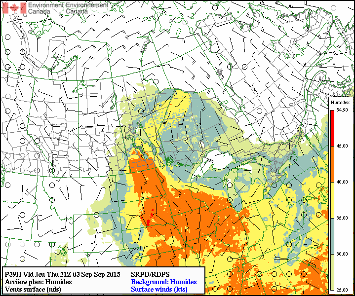
The RDPS is forecasting a large swath of humidex values over 40°C (orange) in Manitoba on Thursday afternoon.
With such substantial humidity in place, overnight lows both tonight and tomorrow night will be quite warm, bottoming out near the 20°C mark. Additionally, expect just slightly breezy winds out of the south.
Friday will bring increasing cloud through the day as a cold front approaches from the west. Temperatures should manage to climb into the upper 20’s before the cloud cover cuts off our daytime heating. At this point, it looks quite likely that a large are of showers and thunderstorms will work their way across the Red River Valley through the afternoon. Severe thunderstorm potential looks minimal at this time, but we’ll keep an eye out and issue and outlook if it seems like it might pose more of a threat. Temperatures will cool down into the mid-teens on Friday night with clearing skies.