The warmer-than-seasonal warmth in place over Southern Manitoba will last just one more day before a cooler air mass works its way into the region behind a cold front that will push through on Thursday.
Today will bring seasonal weather to Winnipeg & the Red River Valley, albeit with a bit of a breezy wind. Under mainly sunny skies, the temperature will climb to around 15°C, which is nearly 5°C above the seasonal average high of 11°C for this time of year. Winds will pick up through the day and be fairly windy out of the northwest with sustained winds climbing to 30–40km/h with gusts to around 50km/h.
Temperatures will dip to around 4–5°C tonight with skies becoming partly cloudy before morning.
Thursday will be quite an unpleasant day that will see a cold frontal passage that will bring in blustery winds and falling temperatures. The day will start off with partly cloudy skies and temperatures climbing to around 10–11°C by midday. Winds will be windy out of the northwest at around 30km/h with some gustiness on top of that. As the cold front passes through in the afternoon, we’ll see mixed-to-cloudy skies develop with a very slight chance of some showers along the front as it passes through. No significant accumulations are expected. Winds will remain blustery with winds remaining at 30–40km/h with gusts as high as 60km/h.
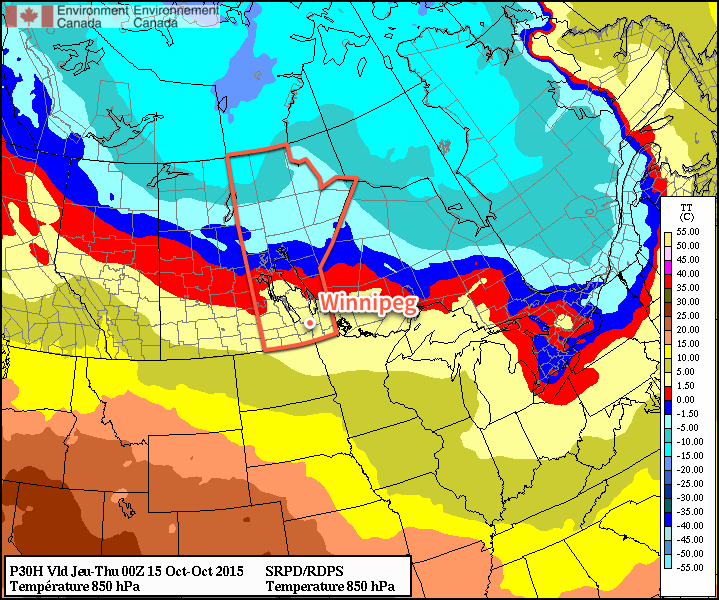
Looking at the forecast 850mb temperatures, the passage of the cold front on Thursday is quite obvious.
As the front passes through, temperatures will drop to around 6°C in the Red River Valley. They’ll continue to drop as winds taper off and skies clear, heading towards an overnight low near –2°C.
Friday will be a pleasant, but cool, day. Winds won’t be much of an issue and temperatures will climb to around 7°C under mainly sunny skies. The low on Friday night will once again be around –2°C under clear skies.
Unremarkable Weekend Ahead
Looking ahead to the weekend, there doesn’t appear to be much to say about it. Through the weekend temperatures will climb back towards seasonal values with a bit of wind on Sunday. No significant precipitation is in store for the region.
Next week looks to have a bit of variability to daytime highs and a couple chances for rain as a slightly more unsettled pattern develops.
It will be a very windy Thanksgiving as a strong low pressure system ushers in potentially damaging winds. By the time you’re reading this your loose objects will probably already be in your neighbour’s yard!
Monday
Today will not be the most pleasant Thanksgiving, as rain and strong winds wreck havoc outdoors. A strong low pressure system and corresponding pressure gradient will generate high to extremely high winds over southern Manitoba on Monday. The highest winds are expected Monday morning, when sustained speeds of 60-80km/h, and gusts to 100km/h or more, are expected. The period of extreme gusts likely won’t last more than a few hours, but during that time it will certainly do some damage, not to mention the fact that you’ll have a lot more leaves to rake!
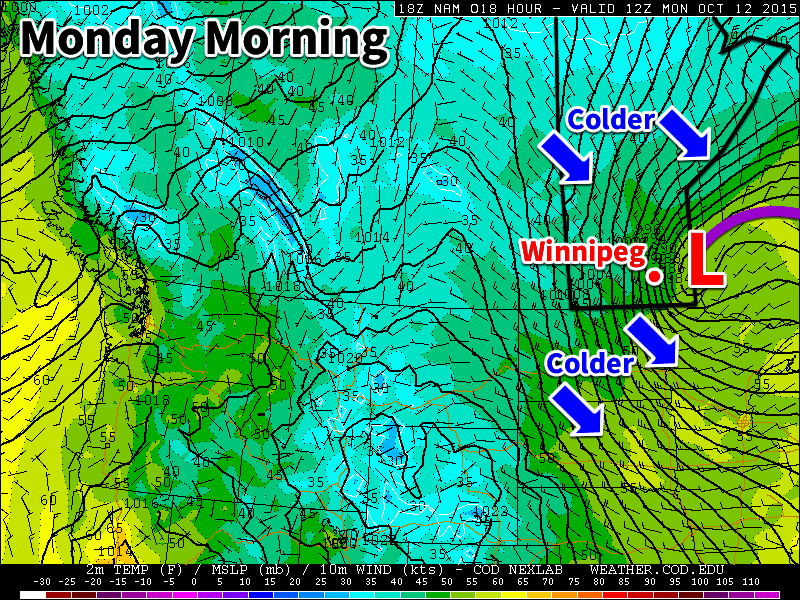
A strong pressure gradient (shown above as tightly packed black lines called isobars) will bring very windy conditions to southern Manitoba on Monday
Today will also be rather soggy, as moderate rainfall occurs in association with this low pressure system. Today’s rainfall amounts will likely be around 5-15mm in the Red River Valley. You’ll have to wait until at least Tuesday for all those wet leaves to dry out!
Tuesday
Tuesday will be much calmer than Monday. Temperatures will climb into the mid teens under mainly sunny skies. Winds will remain breezy from the west, but they will feel light compared to Monday!
Wednesday
Wednesday will feature much the same weather as Tuesday. Temperatures will be in the low to mid teens under mainly sunny skies. Winds will be breezy from the north-west, but once again it will feel like nothing compared to Monday.
Long Range
Long range models continue to show a strong signal for warmer than normal weather through the end of October. Hopefully this will continue to be the trend as we move into winter due to the effects of El Nino.
Over last weekend and the beginning of this week a dangerous flooding situation set up over most of South Carolina.
[map type=”satellite” autofit=”1″ disable_scrollwheel=”1″]
[pin]Gills Creek, South Carolina[/pin]
[pin]Millwood, South Carolina[/pin]
[pin]Kingstree, South Carolina[/pin]
[pin]Sumter, South Carolina[/pin]
[pin]Columbia, South Carolina[/pin]
[/map]
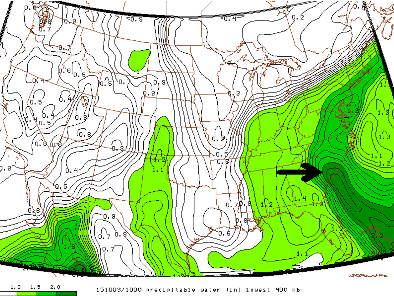
An upper level low which was in place across the southeast CONUS of the United States slowly drifted eastward, but at the same time drew in a tongue tropical moisture into South Carolina where PWATs exceeded 50mm. With much dynamic lift in place provided by the slow moving upper level low, rainfall, which at times very heavy, persisted between October 2nd and the 5th. By the 6th most of the rainfall had finally dissipated and the disturbance had moved out to sea.
A tongue of precipitable water over South Carolina exceeding 50mm Saturday last weekend.
The hardest hit areas comprised of an area along the South Carolina coast extending inland around Charleston and northwest from there. Here, it was common to see storm amounts exceed 500mm. This event broke numerous all time (one, two and three day) rainfall total records including in South Carolina’s capital Columbia which recorded 291mm from the event and a one day, all time, record of 175mm. With all things considered this was a historical event for South Carolina. Unfortunately widespread flash flooding occurred with this heavy rainfall and 17 people perished, it is also expected that this natural disaster will top $1 billion dollars in damages.
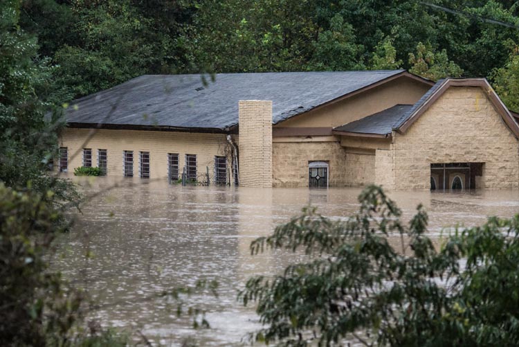
Church underwater in South Carolina. (Souce: Sean Rayford via Jeff Master’s blog)
Here are a few more notable amounts from the event (data from NWS):
Gills Creek, SC storm total of 546mm
Seven stations with over 50 years of data had their wettest October on record, only one week into the month (via weather.com)
Millwood, SC storm total 527mm
Kingstree, SC 24-hour total of 399mm, possibly beating the all-time South Carolina 24 hour precipitation record of 376mm from 1999 during Hurricane Floyd (via weather.com).
Sumter, SC storm total of 528mm
This weekend more soggy weather is in place for South Carolina and flood warnings/flash flood watches have already been issued by the NWS. Not as much rain is expected from this system as it is faster moving and PWATs are not quite as high as seen last week. The one bit of good news that has come out of this flooding is that all moderate drought that was in place has been wiped away from the state.
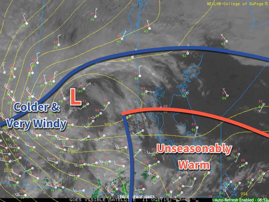
An incredibly abrupt change is in store for Southern Manitoba as a powerful low pressure system is set to blast the near-record warmth out of the region and replace it with unquestionably fall-like weather. As it often is in the shoulder seasons, though, it’s going to be quite the spectacle.
Temperatures have soared into the mid–20’s quickly this morning, rapidly approaching the record high for Winnipeg of 26.1°C set in 1941. A powerful low pressure system to our northwest is approaching, though, and it is going to pack a mean cold front.
Surface analysis valid 12:45PM October 11, 2015
The midday surface analysis shows us three primary features. The first is the frontal wave with warm front across the northern Interlake and cold front draped southwards along the Manitoba/Saskatchewan border. To the southeast of these fronts is the unseasonably warm air mass that is bringing very warm temperatures to the region. The second feature is a low pressure center over central Saskatchewan. The last is a broad cold front that stretches from Central Alberta into Northern Manitoba.
Important to note is that the low pressure centre has occluded[1] and that there is a trowal developing (visible on the satellite image). This lonely low will trundle along for a little bit, until it can re-attach to the cold front slumping down behind it. The temperature gradient along the northern front is actually quite significant, and as the low re-attaches to that frontal wave, it will rapidly intensify. This low will move east-southeast as the steering flow amplifies and digs the upper-level trough.
While we may warm another degree or two, it’s more or less all downhill from here. Wind will continue to pick up out of the west-northwest late this afternoon to around 30km/h as an area of showers blossoms over Southern Manitoba. Widespread shower activity is likely much of the night as strong cooling aloft results in persistent destabilization of the atmosphere. Winds will remain around 30km/h with gustiness on top of that.
The real story will be when the cold front slams through early tomorrow. More rain is likely with the passage of the front, but winds will be the primary issue. As the cold front passes, winds will shift to be out of the northwest and pick up in speed significantly. Sustained winds will likely reach around 55–65km/h, but very strong gusts are possible; it’s highly likely that Winnipeg & the Red River Valley will see wind gusts to 90km/h, however with very strong winds within the conditionally unstable layer and precipitation very likely, it’s possible that wind gusts exceed 100–110km/h. Winds at these speeds can be hazardous when driving and cause damage to buildings (especially roofs) and trees.
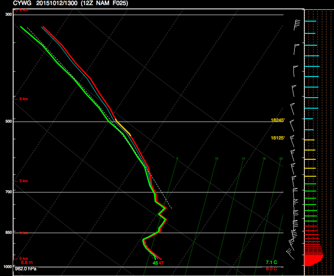
NAM forecast sounding for Winnipeg, valid 12Z October 12, 2015
This forecast sounding for Winnipeg from the NAM shows very strong winds near the surface, with up to 60kt present at the top of the low-level instability.
The strongest winds will begin to subside mid-to-late morning, but strong northwesterly winds of 50km/h gusting to 70km/h will likely be in place for the remainder of Monday. The day will start of with a temperature around 9 or 10°C and see it drop to around 4°C by the end of the day. The bulk of the precipitation should taper off with the winds mid-morning, and when all is said and done, this system will likely produce around 5–10mm of rain over the Red River Valley, although for the northern half, there’s a slight chance of seeing more along the lines of 10–15mm.
Environment Canada has issued a wind warning for the Red River Valley regarding this system with the following discussion:
An intense low pressure system will track across central Manitoba tonight and Monday morning. A strong cold front extending southward from this low will sweep across southern Manitoba tonight. Very strong northwest winds will develop in the wake of this cold front with the strongest winds in the Red River Valley as winds will funnel down the valley. Sustained winds of 60 to 70 km/h with gusts over 90 km/h are likely beginning late tonight and lasting until early afternoon on Monday. Winds will gradually subside Monday afternoon from west to east as this system heads off into Ontario.
Damage to buildings, such as to roof shingles and windows, may occur. Loose objects may be tossed by the wind and cause injury or damage. Be prepared to adjust your driving with changing road conditions due to high winds. Avoid wooded areas to prevent injury from falling trees or branches. Campers should move to sturdy shelters.
Be sure to tie up any loose objects and remove fabric canopies from gazeboes. Bring in any objects that could catch the wind, and maybe flip your trampolines over so the wind doesn’t do it for you. It’s going to be a bit of a busy night and a wild Monday morning, so batten down the hatches!
Occlusion is a part of the natural life-cycle of low pressure systems. In simple terms, it means the low has “detached” from the fronts. ↩