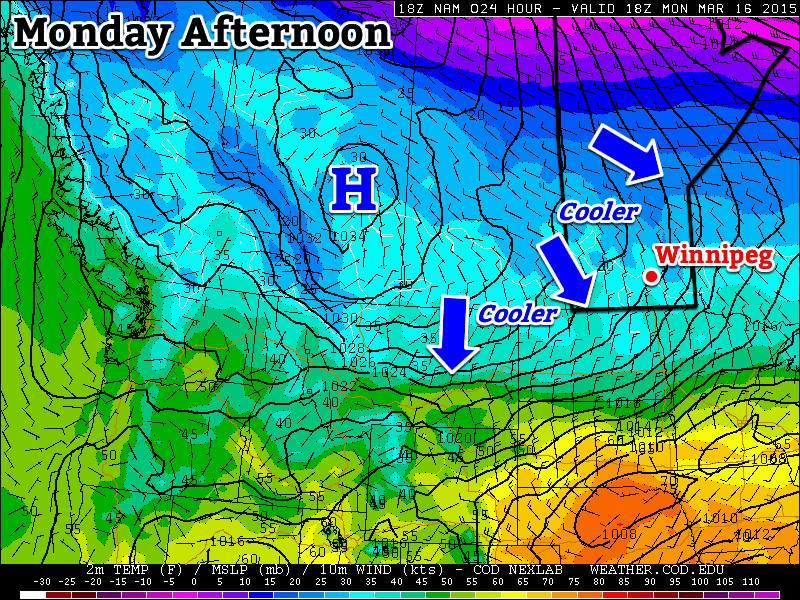
Mild Weather Moderating; Rain Returns Sunday

Temperatures will remain well above normal for two more days before seasonal air begins pushing back into the province through the weekend as a cold front gradually progresses southeastwards. A chance for showers returns to southern Manitoba on Sunday as a disturbance developing in North Dakota causes the cold front to stall out over our area.

Friday
28°C / 16°C
Fog patches in the morning, then hot and humid

Saturday
26°C / 12°C
Chance of morning fog, then mainly sunny and warm

Sunday
⇘ 10°C / 6°C
Cloudy with rain likely

First the good news: after we burn off a little fog that developed overnight, today will be another beautiful, summer-like day with highs in the upper 20’s and surprisingly humid conditions for late September. Strong southerly winds at 40–50km/h with gusts as high as 70km/h will be tapping into a pool of moisture in the Northern Plains and drawing it northwards. Dewpoint values will sit near 17–19°C through much of the southern portions of the province.

Today will bring abnormally high late-September humidity to Southern Mantioba.

Yesterday I erroneously tweeted that our dewpoint of 17.6°C broke the previous record of 16.8°C set in 2008 and that it had been the latest on record[1] such high humidity had been seen in Winnipeg. Rob’s Obs did a little digging and found that the actual record is still held by October 8, 1997 when the dewpoint climbed to 18.6°C. Whoops. I apologize for missing that.

That being said, today will give that record a run for its money; multiple models forecast our dewpoint to climb to 19°C, which if it happens would be the latest 19°C dewpoint on record.

Saturday will be a beautiful day in Winnipeg with a high in the mid–20’s and more comfortable humidity as a cold front gradually approaching begins flushing out some of the moisture in the region. There’s a chance of fog again in the morning and we may see a few clouds around, but the bulk of the day should be mainly sunny. Winds don’t look to be an issue.

This simulated RADAR image from the NAM shows a band of rain stretching across Southern Mantioba on Sunday afternoon.

Things change on Sunday as the cold front that was approaching on Saturday stalls out as a disturbance in North Dakota develops. A band of rain is expected to develop along the stalled out front, spreading from SW Manitoba eastwards through the afternoon until a band of rain stretches across the whole province. Temperatures will start off cool and only drop from there as the rain cools things off a little further and northerly winds at 20–30km/h continue to tap cooler air and bring it into the region. The rain should taper off late in the evening here in Winnipeg with anywhere from 5–15mm falling depending on the exact timing and speed of the system. Temperatures will dip down to around 6°C.

Unsettled Week Ahead Leading to A Cold Snap

Long-range forecasts don’t look particularly great. The first couple days of the week look seasonal temperature-wise. A series of Colorado Lows look to develop mid-to-late week which will bring a chance for showers, but more significantly, begin drawing down much cooler air from the Arctic. The end of the week looks like it will end with an Arctic outbreak bringing another shot of below-normal temperatures and brisk northwesterly winds.


  1. Records for seasonal dewpoint values go start in 1953.  ↩

Fall Starts By Putting Summer to Shame

The first week of fall[1] will start off with weather that will seemingly put this summer to shame. Very warm weather is on the way with potentially record-breaking highs across Southern Manitoba on Thursday!

Wednesday
25°C / 14°C
Cloudy; clearing for a sunny afternoon

Thursday
31°C / 16°C
Mainly sunny; increasing humidity

Friday
30°C / 16°C
Mainly sunny & hot

A prominent upper-level ridge in place over the Prairies has pushed the polar jet stream far northwards and allowed warm air to spread into the Southern Prairies from the United States. As a result, significantly warmer than normal temperatures will continue through the remainder of the week in Winnipeg.

Today will start off fairly cloudy thanks to some stratus cloud that spread northwards ahead of a dissipating trough of low pressure. The cloud should clear out for the afternoon and we’ll see temperatures climb to around 24 or 25°C. The temperature will dip to around 14°C tonight under mainly clear skies.

Thursday and Friday will both bring highs just at or over the 30°C mark under mainly sunny skies. South to southeasterly winds will begin tapping into some moisture from the Central Plains of the US and we’ll see the humidity gradually rise for the latter half of the week. Dewpoint values will climb into the mid-to-upper teens, which when combined with highs near 30°C, it will feel more like the mid-to-upper 30’s. The overnight lows both nights will be in the mid-teens.

Record-Breaking Potential

We have a slight chance of breaking daily record high temperatures on both Thursday and Friday. For Thursday, September 25th the daily record high temperature is 31.1°C set in 1950. For Friday, September 26th the daily record high temperature is 31.7°C set in 1957. Both days will see temperatures climbing to or just above the 30°C mark, and if maximum heating is realized, we may get the bump we need to break one of these records!

Date High Temperature (2014) Record High
September 25 27.7°C 31.1°C (1950)
September 26 30°C (Forecast) 31.7°C (1952)

Cooler Weekend

The weekend is looking great, despite a cool-down that’s in store. Daytime highs will dip around 5°C or so for the weekend with both days seeing highs in the mid–20’s. Fortunately this still puts us around 8°C above normal for the time of year, so there will be little to complain about. We’ll likely see a bit more cloud that we do through the second half of the week, but all in all it will be a gorgeous weekend!


  1. …sort of. Meteorological fall started at the beginning of September, but fall as most people consider it began on September 22nd after the autumnal equinox.  ↩

Above-Normal Weather! Yes!

Above-normal weather is in store for us this week, it’s about time!

Warm weather is in store this week

Monday

Monday
24°C / 11°C
Mainly sunny

Today will be one of the warmest days we’ve seen in some time, with temperatures climbing into the low to mid twenties. Skies will be mainly sunny and winds will be breezy and from the south-west. It will be a very pleasant fall day, perfect for catching up on those outdoor chores that you may have been ignoring lately.

Tuesday

Tuesday
24°C / 13°C
Mainly sunny

Tuesday will not be much different from Monday. Temperatures will once again be in the low to mid twenties with mainly sunny skies. The wind will be gusty from the south, but it will still be a nice day. Unfortunately, that gusty wind will mean there will be a few leaves to start raking up, but that’s hardly reason to start complaining.

Wednesday

Wednesday
23°C / 14°C
Mix of sun and cloud

Another good day is in store for Wednesday. Temperatures will again be in the low to mid twenties. Skies will likely range from mainly sunny to a mix of sun and cloud. There will also be a gusty south wind, just like Tuesday.

Long Range

Long range models continue to show above-normal weather for the foreseeable future. In fact, we may see temperatures climb even higher by late this week into the weekend. This may be our last taste of summer weather, so enjoy it!

Elsewhere in Weather News: September 20th, 2014

Odile Makes Landfall

The active Eastern Pacific hurricane season that was discussed in the EIWN post a few weeks ago continues to produce – another major hurricane was spun up this week. This time it was hurricane Odile, a category four at its maximum strength, which bottomed out at a pressure of 922mb. This hurricane, however, headed towards the Baja Peninsula and made landfall there as a category three hurricane on Sunday night.

Odile just as it was making landfall on the tip of the Baja Peninsula. (Source: NOAA)

Cabo San Lucas was one of the resorts hardest hit as Odile brought winds of 205km/h upon landfall. As expected with a hurricane of this magnitude, significant damage was done to infrastructure as well as three deaths were reported. About 240,000 residents lost power during the event prompting school closures and flight cancellations; causing major headaches to travellers in the popular tourist destination. Odile eventually weakened into a tropical storm as it made its way further north, interacting with terrain and beginning to get torn apart by shear. Even though Odile had weakened substantially, the storm was not done causing trouble to people in the US Southwest, bringing with it its plume of tropical moisture. Reports of flooded houses and washed out roads were coming out of southern New Mexico and Arizona on Thursday and Friday where as much as 100mm fell in some towns (Sept. average rainfall is around 30-50mm in the region). Streams quickly became rivers and one resident perished as he got swept away by the floodwaters. It’s not all bad news to the US Southwest though, as drought continues to improve in the region.

Damage at the Los Cabos Airport. (Source: Reuters via Dailymail)

There’s already another storm; Polo, churning in the East Pacific but it is not expected to take the same path as Odile did. No other tropical storms are expected to impact the Baja Peninsula in the near future.