Summer Weather Continues

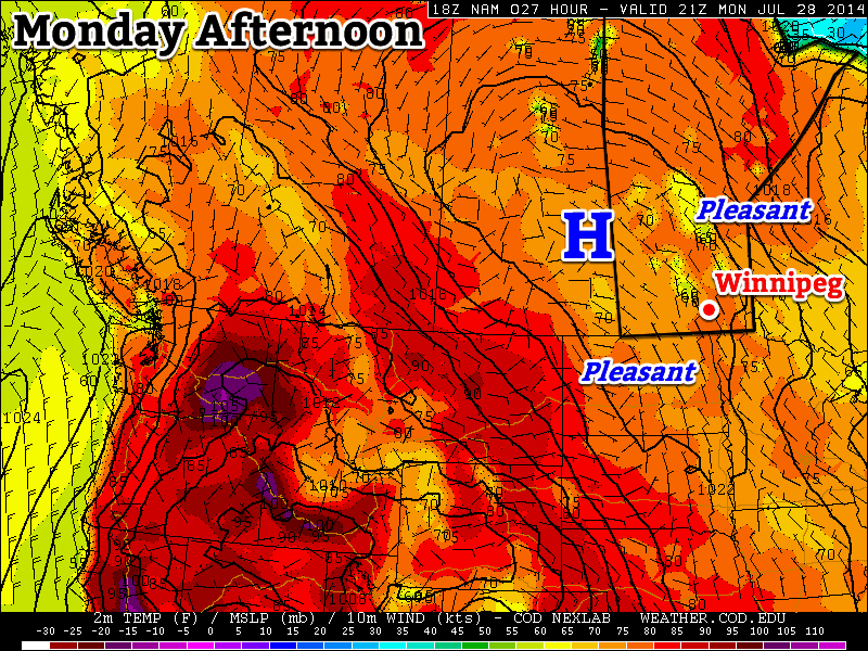
The warm summer weather will continue through the remainder of the week as a strong upper-level ridge over the Western Prairies continues to produce warm, dry weather over Southern Manitoba.

Wednesday
27°C / 13°C
Mainly sunny

Thursday
28°C / 13°C
Mainly sunny; low chance of isolated showers

Friday
28°C / 16°C
Mainly sunny

Today will be another beautiful day with fairly light winds and a high near 28°C. Humidity will stay comfortable and there will be a slight chance of showers through southwest Manitoba north/northeastwards into the Interlake. The lack of any real boundaries should keep things sunny and dry in the Red River Valley. There will likely be a some afternoon clouds, but it will remain mainly sunny.

A clear night under the ridge will mean that things do cool off a bit; expect an overnight low near 13°C through the Red River Valley.

The RDPS is forecasting temperatures in the upper 20s on Thursday afternoon.
The RDPS is forecasting temperatures in the upper 20’s on Thursday afternoon.

Thursday will be another sunny, warm day with a high in the upper 20’s and light winds. The primary difference will be a weak cold front that edges westwards towards the Interlake and Red River Valley. Little activity is expected with it, although by late in the afternoon there will be a slight chance for some isolated showers through the valley. There will be no threat of severe weather. Like Wednesday, it should be a mainly sunny day with just some scattered afternoon cloud.

Temperatures will drop down to the low-to-mid teens on Thursday night.

On Friday, a low pressure system tracking through Northern Manitoba pulls warmer air eastwards across the Prairies. Temperatures aloft will rise through the day and although our daytime high will be in line with the prior days, the warmer air will show itself on Friday night when overnight lows are some 3–5°C warmer than the past few nights. It looks like another pleasant day with highs in the upper 20’s, light winds and ample sunshine.

The Weekend

Overall the weekend looks beautiful. Temperatures will stay in the upper 20’s through the weekend with just a slight chance of showers or thunderstorms on Saturday. Winds will remain light. Summer continues!

Nice Week Ahead!

This week will be quite nice, as a fairly consistent summer-like pattern takes hold.

Monday will be a pleasant day in southern Manitoba

Monday

Monday
24°C / 12°C
Mainly Sunny

Today will be coolest day of the week, but that isn’t actually a bad thing in this case. We should see temperatures climb into the low to mid twenties with light northerly wind. Some smoke from forest fires in northern Canada may trickle into southern Manitoba, but otherwise skies should be mainly clear.

Tuesday

Tuesday
26°C / 14°C
Mainly Sunny

Tuesday look very similar to Monday, except it’ll be slightly warmer. Temperatures in the mid twenties are expected once again, with a light northerly wind. Again, there may be a bit of smoke around, but otherwise it’ll be another great day.

Wednesday

Wednesday
28°C / 16°C
Mainly Sunny. Slight chance of a shower or thunderstorm.

Wednesday should see pleasant continue continue. Temperatures will likely reach the upper twenties in most areas, once again under a light northerly flow. Wednesday’s airmass looks to be a bit more humid than what we saw earlier in the week, so a few pop-up showers and/or thunderstorms are possible in the afternoon and evening. However, these will be very hit and miss, so most people will not be affected.

Long Range

The long range forecast is looking good. Models depict a large upper ridge building over the Prairies this week. That should mean generally hot and dry weather for us. Long range models suggest this ridge may stick around for most of the next 10 days.

Elsewhere in Weather News: July 26th, 2014

Saskatchewan Chase July 24th

An unusually strong upper level low for this time of the year nosed into the southern Prairies and was the focus for severe storms last Thursday. All the ingredients were present for severe storms that day, as Brad alluded to in his discussion of the event posted on the day of. Keeping in mind that this might be one of the last chases this season, due to the jet stream slacking up, a few of us made our way into Saskatchewan to chase the storms.

The day was off to somewhat of a surprising start as we woke up early to find a large squall line was sweeping across southeast Saskatchewan, southwest Manitoba and North Dakota. Thankfully, as the squall line moved away from the main instability axis in the morning it started weakening and its leftover cloud wouldn’t hamper our chances in Saskatchewan for the surface based storm development in the afternoon. After determining that skies would clear in the south-central part of Saskatchewan by late morning, the chase was on. From Winnipeg we drove straight to Brandon, grabbed a quick bite to eat and from there made our way to Weyburn, SK. After arriving in the mid-afternoon, we took a quick look at the satellite only to see some bubbling cumulus and even towering cumulus well to our southwest. By then it was obvious that nothing would fire in the Weyburn area with a stout cap present and no trigger around.

We then had to make a decision to either call it a day or head to south-central SK – where there was plenty of upper forcing and a cold front in the region (further west than what the models were showing). Since we were already that far into SK, we went all in and drove a good 100km west to the Assiniboia region. By the time we got there a couple supercells had already fired; we picked the one that looked best (just south of Assiniboia) and stuck to it.

Picture of the storm as it matured, looking towards a section that was bowing out, with a good shelf cloud. (Source: Matt)
Picture of the storm as it matured, looking towards a section that was bowing out, with a well-defined shelf cloud. (Source: Matt)

Following it for over two hours, we were able to spot two funnel clouds. One may have touched the ground, but we were too far away to tell (hence lack of pictures) while the other a brief funnel that spun up later in the evening on the leading edge of a bow echo. We followed the storm which evolved into a line with multiple bow echos embedded along it. Later in the evening the line became elevated, eliminating the wind threat but still able to produce a lot of cloud to ground lightning. The complex eventually died off in southwest Manitoba and left a large area of stratiform rain in the area.

Overall it turned out to be a fun chase day, with a storm that teased us with a few funnel clouds, combined with good structure and a nice light show. What we didn’t see from that day were the large hailstones that were later reported as well as strong wind gusts of 119km/h reported in Assiniboia.

Uneven Start and a Clean Finish to the Weekend

Unsettled weather will mark the start of the last weekend of July, but conditions will improve for a rather pleasant end and persist into a fairly dry and seasonal start to next week.

Friday: Thunderstorms Possible

Friday
25°C / 15°C
Chance of showers or thunderstorms

Today is off to a cloudy start with a few showers likely through the Red River Valley[1] as the remnants of the overnight activity push off to our east. Skies will remain mostly cloudy until the cold front that brought copious amounts of severe weather to Saskatchewan yesterday pushes through the Red River Valley early this afternoon.

As that cold front moves eastwards, it’s likely that more thunderstorms will fire up along it. Dewpoints in the upper teens will combine with daytime highs in the mid–20’s to produce MUCAPE values as high as 2000J/kg ahead of the front. Shear will be marginal with only around 25–30kt of surface-to–500mb bulk shear and the vertical wind profile isn’t particularly favourable for severe weather. The cold front will be enough of a trigger, although it will be weaker than yesterday and not offer nearly as much forcing as it did then.

As a result, thunderstorms will likely fire up somewhere in the central or eastern Red River Valley and push into the Whiteshell and far SE Manitoba this afternoon. At this point it doesn’t look like there will be an organized severe weather threat, but we’ll be taking a look a little later this morning to assess whether or not the severe threat needs upgrading.

The HRRR forecast shows a line of showers and thunderstorms pushing eastwards along the cold front this morning.

Other than the storms, the day will be pleasant. Before the cold front passes the Red River Valley will be under a relatively light southerly or southeasterly wind. It will be fairly humid and temperatures in the low 20’s until the passage of the front, after which westerly winds at 30–40km/h bring in much drier air. The afternoon sunshine should help our daytime high climb to around 25°C.

Temperatures will drop to around 14°C under clear skies and light winds tonight.

Showery Saturday

Saturday
24°C / 13°C
Mainly cloudy with widespread showers

Tomorrow will be the least pleasant day of the next few. A strong upper-level low will slide across Southern Manitoba through the day, producing widespread showers underneath it. There may be a few isolated thunderstorms, but for the most part most areas in Southern Manitoba will be seeing a fairly wet day. Winds will generally be 20–30km/h through much of the day, shifting from southwesterly or westerly to northerly through the day and overnight.

Skies will begin to clear overnight as the temperature drops to around 13°C.

Sunny Sunday

Sunday
24°C / 13°C
Mainly sunny

Sunday will likely start off with some low cloud trapped in the boundary layer making for mixed to mostly cloudy skies. As the temperature rises through the morning, the clouds will gradually break up leading to a mainly sunny afternoon with some scattered clouds. Highs will be around the 24–25°C mark and temperatures will drop to around 13°C once again on Sunday night.

This pleasant weather will continue through the first half of next week. Another strong ridge is forecast to build into BC/Alberta, which will keep temperatures seasonal[2] and the weather dry.


  1. Full discretion: I’m writing this on Thursday evening, and still unsure on how much of Thursday night’s convective activity will survive to the Red River Valley.  ↩
  2. Seasonal highs in Winnipeg right now are around 26°C. Seasonal lows are around 13°C.  ↩