Cooler Weather Rounds Out Weekend

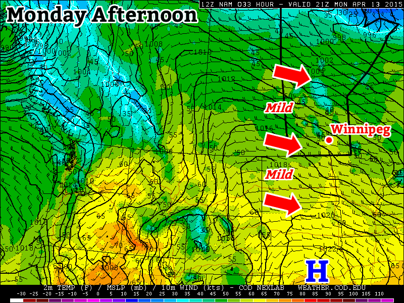
The unseasonably warm weather that’s been in place over Southern Manitoba will remain for a couple more days before a big shift in the weather pattern behind a low pressure system passing through on Sunday that will bring cooler air back to the region for next week. The shift in conditions will be quite a shock to the system after a pleasant stretch of above-normal temperatures looks to be replaced with the potential of a return to…snowier conditions.

Today will be a fairly pleasant day in the Winnipeg area. On Wednesday we had mentioned the possibility that today might be another very windy day but, thankfully, it looks like the system that guidance suggested would be a bit of a trouble-maker has ended up weaker and further north than it appeared earlier in the week. As such, we’ll see slightly warmer temperatures with a high near 18°C with somewhat breezy northwesterlies developing to around 30 gusting 50km/h. Tonight will bring mainly clear skies and a low near 3°C with light winds.

Saturday is looking like another beautiful day as warm air surges northwards ahead of Sunday’s low pressure system. Winds will be a bit breezy out of the south to southeast at around 20–30km/h in the morning but will likely taper off a bit into the afternoon, making for an exceptionally pleasant sunny afternoon with a high near 20°C and fairly calm winds. Unfortunately, it’s all downhill from there. Cloud will move in on Saturday evening and through the overnight period as a low pressure system pushes northwards out of the Central Plains of the United States. Expect a low near 6°C.

Sunday Brings Showers & Transition to Cooler Weather

Forecast 1000–500mb Thickness Sunday into Monday

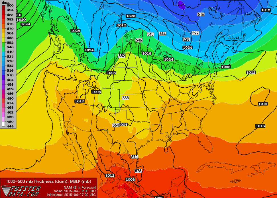
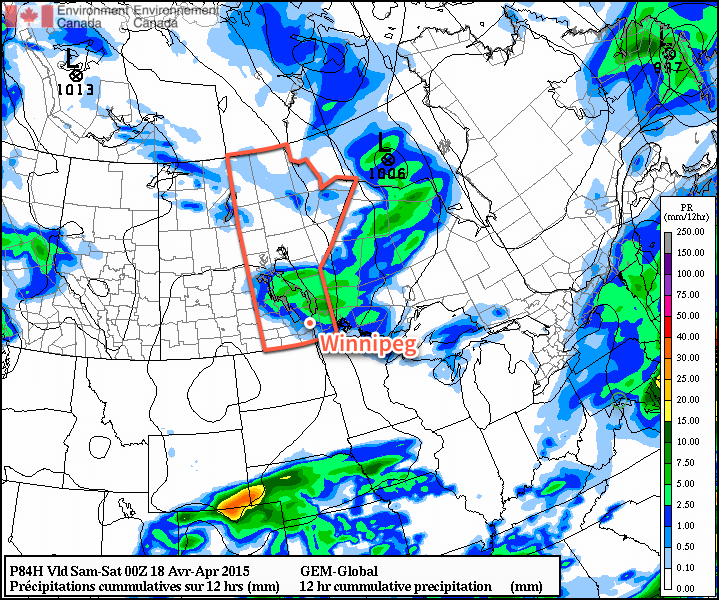
Sunday will mark the transition into a cooler air mass as a fairly complex pattern change gets underway. The weather will be dominated by two primary features: a low pressure system lifting north-northeast out of the Northern Plains of the US and a shortwave moving into Manitoba from Saskatchewan. The two systems will undergo a complex merging and look to stall out a bit over Northern Ontario. This stalling out will resulting in an amplification of the long-wave trough developing over the region resulting in a plunge of colder air southwards over the Eastern Prairies. This is reflected very nicely in the above graphic which shows the forecast 1000–500mb thicknesses[1] plunging behind the low pressure system.

So what does that mean for Sunday? Well, there’s a bit of ambiguity as to what will happen here in Winnipeg as a lot will depend on the exact timing of and how the two systems merge. We’ll definitely see cloudy skies, likely see a very good chance of showers through the day. Precipitation will fall as rain for most of the day, but likely switch over to snow sometime in the early evening. Snowfall amounts won’t be big, however a couple cm are certainly possible.

The high on Sunday will be near 10°C with a slight northwesterly breeze. Temperatures will drop just below freezing on Sunday night. Rainfall totals of 5–10mm are possible with 2–3cm of snow possible on Sunday night.

Long Range

Heading into Monday, it looks like the Red River Vally will see flurries, highs near the freezing mark and blustery northwest winds. After that, the rest of the week looks fairly quiet with little in the way of precipitation expected. Daytime highs through much of the week will be more than 5°C below the seasonal values of 11–12°C.


  1. The 1000–500mb thickness is the distance, or thickness, between the 1000mb level (near-surface) and 500mb level (averages around 18,000ft and is often considered the steering flow for weather systems). Higher thickness values correlate to warmer temperatures and lower thicknesses correlate to colder temperatures.  ↩
Fire crews were kept busy with a grass fire near the west perimeter Monday evening.

Dry & Mild Weather Continues

Dry weather is increasingly becoming the predominant weather story for our region as an extended period of little-to-no precipitation develops. Through March, the Winnipeg airport reported only 13.8mm of precipitation, barely over half of the normal of 24.5mm[1]. So far, half-way through April, we’ve seen just 2.0mm of precipitation, well off the pace of the normal of 30.0mm. This is all in addition to coming off the 9th driest meteorological winter on record. The dry weather has led to a fatality due to a brush fire in the RM of Rhineland, a fire that temporarily closed rail lines in Winnipeg near the Perimeter Highway and Wilkes Ave.[2] and the cancellation of Manitoba burning permits.

The problems are even worse south of the border, though, with some areas in North Dakota seeing record dryness. On Monday, the NWS Grand Forks office tweeted a new record for Grand Forks:

They followed it up by also mentioning that Fargo has seen it’s 3rd driest October-April stretch. The dry weather has created an excessive fire hazard in the region and has resulted in numerous “Red Flag” warnings.[3]

Unfortunately, little relief is in sight. The warm, windy weather will continue over the coming days with no significant precipitation.

Today will be another very warm day; our forecast high of 22°C is over 10°C above normal for this time of year. The warmth will come along side very strong southerly winds, though, with sustained winds strengthening to 50–60km/h and gusts possibly as high as 90km/h. Environment Canada issued a wind warning at 11:51PM last night anticipating the strong winds. Winds will remain strong into the evening before diminishing overnight. There will be some cloud moving in overnight associated with a cold front moving through as the temperature drops to around 6°C. There’s a very slight chance of a few sprinkles overnight into early Thursday morning, but at this point it looks like any amounts, if they were to occur, would be insignificant.

Thursday will be a relatively quiet day. Temperatures will remain mild with highs near 16°C, but the more notable aspect of the day will be the calm winds thanks to a ridge of high pressure over the region. Expect cloud to move in on Thursday evening as we drop to a low near 6°C again.

GPDS 12hr. QPF valid 00Z April 18th, 2015
The GDPS shows Winnipeg on the edge of an area of accumulating showers on Friday.

Friday’s main weather story will be a low pressure system slumping through Southern Manitoba. It will bring an area of showers with it, however at this point general model consensus is that Winnipeg will likely see a few sprinkles, but the accumulating rainfall of a few mm will remain further north in the Interlake. As the system passes, a cold front will sweep through the Red River Valley and usher in strong northwest winds to around 40 gusting 60km/h. The temperature will climb to near 14°C under more cloud than sun. Skies will clear and winds diminish heading into the evening as the temperature heads to a low of about 3 or 4°C.

Long Range

In general, the weather continues to look warm and fairly dry. No significant precipitation is expected in the next 10 days across the Southern Prairies and Northern Plains. Any chances for rain in the 4–10 day period look pretty uncertain at best as different models are tracking fairly divergent solutions. The warm weather looks to stick around until next week before some cooler weather may begin moving in.


  1. Based on the 1981 – 2010 climate normals.  ↩
  2. Pictured above; credit to Christopher Stanton / Global News.  ↩
  3. Red flag warnings are issued when weather conditions combine with dry hydrological conditions to present an extreme fire hazard.  ↩

Warm Weather Continues

Warm weather will continue this week as temperatures remain well above seasonal values.

Mild weather will continue in southern Manitoba on Monday

The Week Ahead

Monday

Today will be mild, but breezy. High temperatures will sit in the low teens with a gusty west wind. Skies should remain mainly sunny, making for a generally nice day.

Tuesday

A developing low pressure system to our west will give us south-easterly winds for Tuesday. This southerly flow will also draw up some warmer air, pushing high temperatures into the upper teens. Skies are expected to be a mix of sun and cloud as an upper disturbance passes through the region.

Wedensday

Wednesday looks to be the warmest day of the week as high temperatures climb into the 20s once again. These warm temperatures will be the result of a stiff southerly flow ahead of an approaching low pressure system. Skies are expected to be mainly sunny, but with a gusty south wind.

Long Range

The long range forecast continues to look warm. However, a cold front will pass through southern Manitoba late on Wednesday, ushering in slightly cooler conditions for Thursday. Medium-range models suggest that above-normal weather will stick around until at least the beginning of the weekend, which will mean high temperatures remaining well into the teens. Further out in the long range it appears another cold front may pass through later on the weekend, which may cool us down temporarily, but it’s too soon to say for sure.

Wednesday? Beautiful, No Foolin’! Thursday? Not So Much…

Some of the warmest weather so far this year will move into the region today, drawn eastwards by a fairly strong spring storm moving through the Central Prairies. The warmth is not meant to last, though, as a strong cold front pushes through and brings below-normal temperatures for the remainder of the week.

Wednesday
16°C / 2°C
Windy with sunny breaks this afternoon

Thursday
⇓ -2°C / -12°C
Cloudy & windy; chance of showers or flurries

Friday
0°C / -8°C
Mainly sunny & cool

Today will be quite a warm day thanks to very mild air over our region; 925mb temperatures are expected to climb to around 9°C, which should translate to daytime highs near 15 or 16°C once we sunshine this afternoon. Speaking of sunshine, while today is starting off cloudy, we should the cloud cover break up this afternoon as the dry slot associated with the Central Prairie low moves across Southern Manitoba. Alongside the sunshine and clearing will be fairly gusty westerly winds to 30–40km/h with gusts as high as 60km/h. The winds will taper off in the evening as we head to an overnight low of around +2°C.

RPDS 3hr. QPF & MSLP valid Thursday, April 2, 2015
The RPDS shows an area of light precipitation moving through the Red River Valley on Thursday with a relatively tight pressure gradient that will produce gusty northerly winds.

Thursday will be a significantly less pleasant day as a cold front pushes through Southern Manitoba, bringing with it cooler temperatures, gusty northerly winds and a fairly good chance for some shower or flurry activity. Temperatures in Winnipeg will slide through the morning, settling near –1 or –2°C for much of the afternoon as gusty northerly winds to around 40km/h tap cooler air from the north. The best chance for any shower or flurry activity would be through the morning & early afternoon. Skies will clear out Thursday evening as we head to a low near –12°C.

Friday will be a benign weather day for Winnipeg & the Red River Valley, but temperatures will be well below normal. Daytime highs will only be around +1 or +2°C through the Red River Valley, which is a few degrees below normal for this time of year. Fortunately, winds will be light and with that increasingly strong April sun shining, it won’t feel so bad. Expect temperatures to drop to around –8°C on Friday night with partly cloudy skies.

Quiet Weekend Ahead

The weekend is looking fairly quiet for Winnipeg with seasonal to slightly below-seasonal temperatures and a few clouds. A ridge of high pressure building in from the Arctic looks to keep most disturbances to the south of Winnipeg, however with the main frontal zone setting up near the U.S. border and a few shortwaves rippling along, areas along the U.S. border in Southern Manitoba may see a few showers or flurries through the weekend. Nothing significant is expected.

NAEFS 8-14 Day Temperature Anomaly Outlook (issued 12Z March 31, 2015)
The NAEFS 8-14 day temperature anomaly forecast show above-seasonal warmth returning to Manitoba.

In the longer range, it looks fairly likely that we’ll see a return to above normal temperatures through the second week of April as the storm track shifts back further north; while above normal temperatures will return, it looks like much of the warm weather will be associated with weather disturbances, making it likely that we’ll see more of a “roller coaster” temperature pattern than a prolonged period of warm, dry weather. Only time will tell, though! For now, expect a few cool days and then a stretch of near-seasonal temperatures.