Japan Faced with Severe Flooding

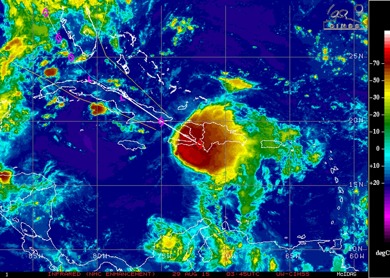
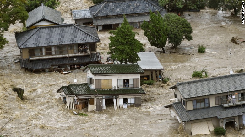
The worst flooding that some parts of Japan have seen in decades occurred this past week as a tropical storm brought tropical, moisture-laden air to the country.

[map autofit=”1″ disable_scrollwheel=”1″] [pin]Sendai[/pin] [pin tooltip=”Ikari”]Ikari Nikko, Tochigi Prefecture 321-2806[/pin] [pin]Nikko[/pin] [pin]Kanuma[/pin] [pin]Tokyo[/pin] [pin tooltip=”Joso”]Joso, Japan[/pin] [/map]

Tropical storm Etau had the worst impact on Japan’s biggest island, Honshu. Here heavy rain bands were set up for over 24 hours in the area and rainfall totals were further enhanced by local topography. Unstable terrain leading to mudslides also grew to be a concern as heavy rain fell and the ground became saturated. By the end of this past week, when the rain was all said and done, some villages in central and southern Honshu had rainfall totals near 700mm, with some 24 hour totals topping 500mm. It’s to note that the average monthly rainfall for September in Tokyo is less than a third of that (181mm). Here are a few of the notable rainfall amounts (provided by weather.com) :

  • Ikari 551*mm* in 24 hours.
  • Nikko 668*mm* rainfall total.
  • Kanuma 444*mm* in 24 hours, which is more than double the previous 24 hour record for the city (record 212*mm* in 2002).
  • Sendai central business district 269*mm* 24 hour total
Levees of the Kinugawa River breached in Joso from the heavy rains. (Source: AFP/via TWC)

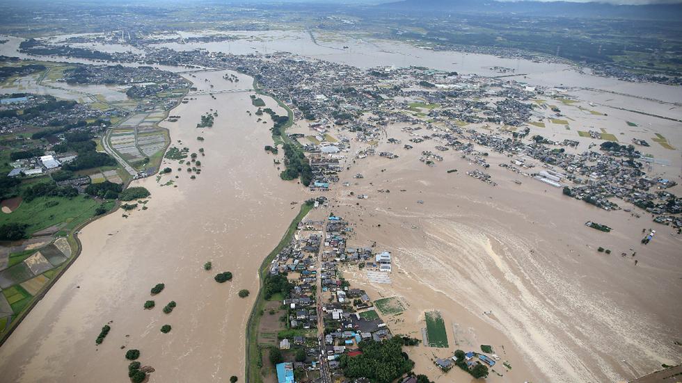
What resulted from these very high rainfall amounts was historic flooding, mainly north and northeast of Tokyo. Over 13,500 buildings were reported to be completely flooded out by officials in result of the heavy rain falling as well as some levees being breached north of Tokyo. In total 3 people have been confirmed to have died from this rainfall event and 23 are still missing; mostly from landslides. It was reported that 185,000 were forced to leave their homes, while over two million more were advised that they should leave by authorities. It’s not possible to assign a dollar amount to the damages yet but authorities speculate it will at least be in the hundreds of millions.

Flooding in the city of Joso, where floodwaters nearly reached the second story of homes. (Source: CNN)

A few showers are expected this weekend in the Tokyo area but nothing close to the magnitude of what seen this past week.

Erika: Yet Another Tropical Disturbance in the Atlantic

Yet another tropical disturbance has developed over the Atlantic this week thanks to another mid-level wave traversing off the coast of Africa westwards over the Atlantic. It’s currently impacting the Dominican Republic and is forecast to head west-northwest towards the southeastern United States.

[map type=”terrain” autofit=”1″ disable_scrollwheel=”1″] [pin]Dominica[/pin] [pin]Dominican Republic[/pin] [/map]

Erika, which formed near the Cape Verde Islands, was centered near the southwest corner of the Dominican Republic as of Friday night bearing sustained winds of 75km/h and a rather unimpressive pressure of 1000mb. The tropical disturbance has struggled mightily at getting even somewhat organized over ocean waters; dry air and strong shear were both contributing factors to this. Erika is expected to continue experiencing problems organizing in the near future due to the strong wind shear in place, as well as a new concern – the rugged islands of Hispaniola.

IR satellite image of Erika on Friday night. Erika looks rather disorganized due to relatively strong shear present, but could still bring heavy rainfall to some Caribbean Islands. (Source: NHC)

The heavy rains that accompany this tropical disturbance are not to be underestimated, however. Heavy rainfall in the order of 100mm to 150mm, as high as 250mm locally, is expected to fall across both the Dominican Republic and its neighbouring country, Haiti. There have already been 20 confirmed deaths associated with Erika from the island of Dominica (located in the Lesser Antilles), and three dozen more residents are still missing. In consequence, this tropical storm has been the deadliest natural disaster for the country since 1979.

The future of Erika remains uncertain at this point. Most models show Erika as weakening over the Caribbean islands (due to the shear/terrain problems discussed), then emerging over waters off of the western coast of Florida as a weak tropical storm. Overall, it’s unlikely that Erika will become anything more than a tropical storm that is just a rain-maker for southeast US.

In other news, it had been the year of the hurricane in the Eastern Pacific near the Hawaiian Islands. Several hurricanes have brushed by Hawaii already this year – an unusual occurrence. Yet another is on its way in the coming week. Hurricane Ignacio (category one) is expected to pass close to Hawaii. What remains to be seen is how close – Hawaii can at least expect high surf and heavy rainfall from the outer bands of Ignacio on Monday, but there is still some uncertainty on strength of the winds which depends on how close Ignacio comes. Another hurricane in the Eastern Pacific is churning; Jimena, is a high-end category four but is not expected to have any impact to land in the near future.

Typhoon Soudelor Takes Aim at Taiwan and China

A tropical disturbance that was once a powerful super typhoon over the open waters of the Western Pacific earlier this week has now slightly weakened and is taking aim at southeastern Asia.

As of Friday night Soudelor was a typhoon of strength equivalent to a category two hurricane and had just made landfall on Taiwan’s northeast shores. The typhoon packed sustained winds of about 170km/h gusting to over 200km/h Friday night as it made a direct landfall on the island of Taiwan. The biggest threat with the typhoon, however, was rainfall. Taiwan’s rugged terrain meant that orographic lift (lifting of air pushed up the mountains) would greatly enhance precipitation amounts, especially on the north side of the island. Models showed that as much as a metre of rainfall (or more) could fall before it is all said and done.

Visible satellite image of Soudelor at sunrise late Friday evening (our time). (Source: Himawari Sat.)

The effects of typhoon Soudelor are still uncertain as of Friday evening but the Taiwanese authorities reported that there were over 2.6 million residents without power, wreaking havoc on day to day activities as well as travel in the region. In addition to that, as of Friday night there were four confirmed deaths associated with the typhoon, two of which were associated with the storm surge which had the biggest impact on the northeast shoreline. The station that clocked the highest rainfall amounts as of Friday evening was the town of Taipingshan, which was already well over a metre of rainfall (1,241mm). Taipei, which is less than 50km from this town, had already recorded an astonishing 500mm in some parts of the city.

Conditions are expected to continue to be poor until later today, as the heavy rains are expected to continue to fall in the northern half of the country. Soils will become saturated, if not already, and overwhelmed by the rainfall, resulting in mudslides in the mountainous regions – a region of Taiwan which is known to be very prone to these types of disasters. Soudelor’s effect on China isn’t expected to be as severe, but heavy rain/flooding will once again be the main threat as the tropical system moves over China’s mainland and begins to weaken.

Typhoon Nangka Wreaks Havoc on One of Japan’s Main Islands

This past week a typhoon made landfall on one of Japan’s islands, the island of Shikoku and with it brought winds the equivalent of a category one hurricane gusting up to 185km/h.

[map type=”terrain” autofit=”1″ disable_scrollwheel=”1″]
[pin]Island of Shikoku[/pin]
[pin]Kamikitayama, Japan[/pin]
[/map]


Nangka initially formed in the middle of the Western Pacific Ocean about over a week ago and slowly strengthened as it approached Japan; it traveled over 5000km to make landfall. Over open waters it peaked at the equivalent of a category four hurricane, with sustained winds of over 200km/h and gained super typhoon status. Slightly cooler ocean waters (of 26°C to 27°C) towards Japan weakened the typhoon somewhat before it made landfall, but with that said, the typhoon’s impacts were still fairly significant. In expectation of the typhoon 550,000 residents were either issued a mandatory evacuation notice or voluntary evacuation notice, in the most prone-to, low-lying areas near the coast.

Beautiful satellite image of Nangka earlier this week while it was still over open waters. (Source: NWS OPC)

In total, two people perished from the typhoon and about three dozen people sustained injuries – thankfully it wasn’t worse due to good planning by authorities to get the people most at risk out. Numerous rail runs and flights were cancelled, affecting about 200,000 people’s daily activities. Some flooding did occur as the typhoon brought a plume of tropical moisture to the region with it, which led to rainfalls in excess of 700mm in the hardest hit areas in 48 hours (740mm reported in Kamikitayama). Just over 100 houses were reported to have been completely flooded out

Since Nangka has made landfall it has progressed to its dissipating stage, and possibly extratropical transition by the end of the weekend. However, it will still bring with it the threat of heavy rainfall in the northern Japanese islands and mountainous areas even though it continues to weaken. On average there are 16 typhoons in the Western Pacific in a year, and this year’s count is currently at seven. Most storms form in the Western Pacific between May and November (because shear is weaker) but there are occasional storms that form in the other months of the year.